Title: National Presidential Primary County and State Maps (1912-2020)
Post by: RI on June 11, 2009, 08:26:46 PM
Here are maps of what I have been able to find so far for past presidential primaries. I was wondering if anyone could help find more data or if they knew where more data could be found. I've scoured the internet in all the usual places, State SOS and Election board websites, ourcampaigns.com, and online blue books, not to mention sending out probably hundreds of emails, and this is what I've come up with.
I have every primary state back to 1968 filled in (with a couple of exceptions) along with as much caucus data as I can find (most blank states, at least back until 1968, are caucus states and therefore have limited data available). Before 1968, I have much more limited data, but this is very much a work in progress, and I am adding new data as often as I can.
Occasionally you will see a state without variations in shade, which means that I do not know anything more than who won the county. Three states on the 2008 Democratic primary map have results displayed by legislative district rather than by county as this is the only data available (Alaska, Kansas, and North Dakota). North Dakota is also displayed as such on the 2008 Republican primary and 2004 Democratic primary maps. All Alaska maps are in House Districts.
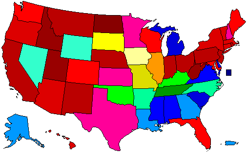
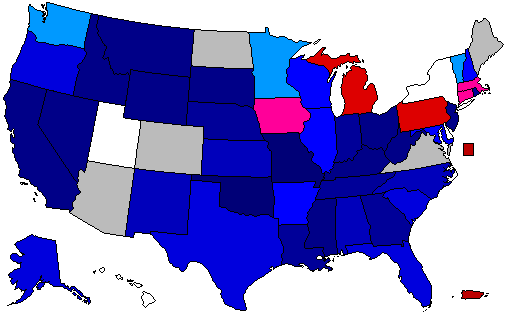
2016 Democratic:
() (https://uselectionatlas.org/FORUM/GALLERY/2947_08_06_16_2_37_53.png)
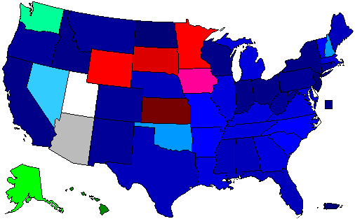
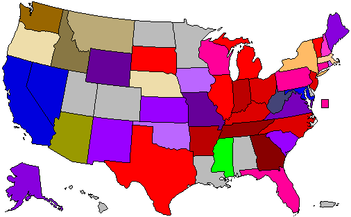
2016 Republican:
() (https://uselectionatlas.org/FORUM/GALLERY/2947_08_06_16_2_38_27.png)
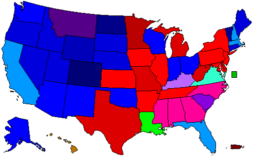
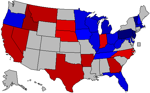
2012 Democratic:
( ) (https://rynerohla.com/wp-content/uploads/2017/11/2012-Democratic-Presidential-Primaries-by-County.png)
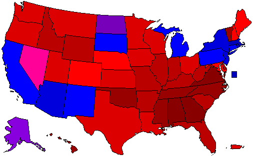
2012 Republican:
() (https://uselectionatlas.org/FORUM/GALLERY/2947_06_01_16_5_22_52.png)
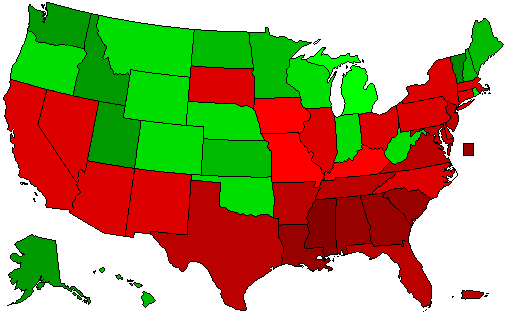
2008 Democratic:
(Image Link) (http://maps.rynerohla.com/wp-content/uploads/2022/02/2008-Democratic-Party-Presidential-Primaries-by-County-with-All-Contests.png)
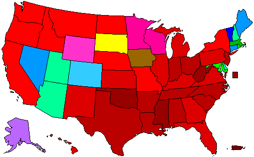
2008 Republican:
(Image Link) (http://maps.rynerohla.com/wp-content/uploads/2022/02/2008-Republican-Party-Presidential-Primaries-by-County-with-All-Contests.png)
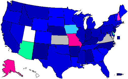
2004 Democratic:
() (https://uselectionatlas.org/FORUM/GALLERY/2947_11_12_15_2_29_55.png)
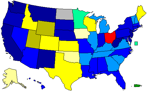
2000 Democratic:
(Image Link) (http://maps.rynerohla.com/wp-content/uploads/2022/02/2000-Democratic-Presidential-Primaries-Map-with-All-Contests.png)
2000 Republican:
(Image Link) (http://maps.rynerohla.com/wp-content/uploads/2022/02/2000-Republican-Party-Presidential-Primaries-with-All-Contests.png)
1996 Democratic:
( ) (https://rynerohla.com/wp-content/uploads/2017/11/1996-Democratic-Presidential-Primaries.png)
1996 Republican:
(Image Link) (http://maps.rynerohla.com/wp-content/uploads/2022/02/1996-Republican-Primary-County-Map-with-All-Contests.png)
1992 Democratic:
(Image Link) (http://maps.rynerohla.com/wp-content/uploads/2022/02/1992-Democratic-Primary-County-Map-with-All-Contests.png)
1992 Republican:
( ) (https://rynerohla.com/wp-content/uploads/2017/11/1992-Republican-Presidential-Primaries.png)
1988 Democratic:
() (https://uselectionatlas.org/FORUM/GALLERY/2947_18_12_15_4_18_17.png)
1988 Republican:
() (https://uselectionatlas.org/FORUM/GALLERY/2947_18_12_15_4_22_29.png)
1984 Democratic:
() (https://uselectionatlas.org/FORUM/GALLERY/2947_18_12_15_4_19_12.png)
1980 Democratic:
(Image Link) (http://maps.rynerohla.com/wp-content/uploads/2022/02/1980-Democratic-Party-Presidential-Primaries-by-County-with-MI-Caucus-by-CD.png)
1980 Republican:
(Image Link) (http://maps.rynerohla.com/wp-content/uploads/2022/02/1980-Republican-Presidential-Primaries-by-County.png)
1976 Democratic:
() (https://uselectionatlas.org/FORUM/GALLERY/2947_26_01_16_11_40_29.png)
1976 Republican:
(Image Link) (http://maps.rynerohla.com/wp-content/uploads/2022/02/1976-Republican-Primary-County-Map.png)
1972 Democratic:
(Image Link) (http://maps.rynerohla.com/wp-content/uploads/2022/02/1972-Democratic-Presidential-Primaries-with-Iowa-County-Convention-Results.png)
1968 Democratic:
(Image Link) (http://maps.rynerohla.com/wp-content/uploads/2022/02/1968-Democratic-Presidential-Primaries.png)
1968 Republican:
() (https://uselectionatlas.org/FORUM/GALLERY/2947_11_12_15_2_28_15.png)
1964 Democratic:
( ) (https://rynerohla.com/wp-content/uploads/2017/11/1964-Democratic-Presidential-Primaries-by-County.png)
1964 Republican:
() (https://uselectionatlas.org/FORUM/GALLERY/2947_20_11_15_2_54_14.png)
Some older maps:
1952 Democratic:
() (https://uselectionatlas.org/FORUM/GALLERY/2947_11_12_15_1_01_33.png)
1952 Republican:
(Image Link) (http://maps.rynerohla.com/wp-content/uploads/2022/02/1952-Republican-Presidential-Primaries-by-County.png)
1948 Republican:
( ) (https://rynerohla.com/wp-content/uploads/2017/11/1948-Republican-Presidential-Primaries.png)
1924 Republican:
() (https://uselectionatlas.org/FORUM/GALLERY/2947_09_03_16_11_02_35.png)
1920 Republican:
() (https://uselectionatlas.org/FORUM/GALLERY/2947_09_03_16_10_24_54.png)
1916 Republican:
() (https://uselectionatlas.org/FORUM/GALLERY/2947_09_03_16_9_46_44.png)
1912 Democratic:
() (https://uselectionatlas.org/FORUM/GALLERY/2947_05_01_16_2_25_32.png)
1912 Republican:
() (https://uselectionatlas.org/FORUM/GALLERY/2947_05_01_16_2_24_44.png)
I have every primary state back to 1968 filled in (with a couple of exceptions) along with as much caucus data as I can find (most blank states, at least back until 1968, are caucus states and therefore have limited data available). Before 1968, I have much more limited data, but this is very much a work in progress, and I am adding new data as often as I can.
Occasionally you will see a state without variations in shade, which means that I do not know anything more than who won the county. Three states on the 2008 Democratic primary map have results displayed by legislative district rather than by county as this is the only data available (Alaska, Kansas, and North Dakota). North Dakota is also displayed as such on the 2008 Republican primary and 2004 Democratic primary maps. All Alaska maps are in House Districts.
2016 Democratic:
() (https://uselectionatlas.org/FORUM/GALLERY/2947_08_06_16_2_37_53.png)
2016 Republican:
() (https://uselectionatlas.org/FORUM/GALLERY/2947_08_06_16_2_38_27.png)
2012 Democratic:
(
) (https://rynerohla.com/wp-content/uploads/2017/11/2012-Democratic-Presidential-Primaries-by-County.png)2012 Republican:
() (https://uselectionatlas.org/FORUM/GALLERY/2947_06_01_16_5_22_52.png)
2008 Democratic:
(Image Link) (http://maps.rynerohla.com/wp-content/uploads/2022/02/2008-Democratic-Party-Presidential-Primaries-by-County-with-All-Contests.png)
2008 Republican:
(Image Link) (http://maps.rynerohla.com/wp-content/uploads/2022/02/2008-Republican-Party-Presidential-Primaries-by-County-with-All-Contests.png)
2004 Democratic:
() (https://uselectionatlas.org/FORUM/GALLERY/2947_11_12_15_2_29_55.png)
2000 Democratic:
(Image Link) (http://maps.rynerohla.com/wp-content/uploads/2022/02/2000-Democratic-Presidential-Primaries-Map-with-All-Contests.png)
2000 Republican:
(Image Link) (http://maps.rynerohla.com/wp-content/uploads/2022/02/2000-Republican-Party-Presidential-Primaries-with-All-Contests.png)
1996 Democratic:
(
) (https://rynerohla.com/wp-content/uploads/2017/11/1996-Democratic-Presidential-Primaries.png)1996 Republican:
(Image Link) (http://maps.rynerohla.com/wp-content/uploads/2022/02/1996-Republican-Primary-County-Map-with-All-Contests.png)
1992 Democratic:
(Image Link) (http://maps.rynerohla.com/wp-content/uploads/2022/02/1992-Democratic-Primary-County-Map-with-All-Contests.png)
1992 Republican:
(
) (https://rynerohla.com/wp-content/uploads/2017/11/1992-Republican-Presidential-Primaries.png)1988 Democratic:
() (https://uselectionatlas.org/FORUM/GALLERY/2947_18_12_15_4_18_17.png)
1988 Republican:
() (https://uselectionatlas.org/FORUM/GALLERY/2947_18_12_15_4_22_29.png)
1984 Democratic:
() (https://uselectionatlas.org/FORUM/GALLERY/2947_18_12_15_4_19_12.png)
1980 Democratic:
(Image Link) (http://maps.rynerohla.com/wp-content/uploads/2022/02/1980-Democratic-Party-Presidential-Primaries-by-County-with-MI-Caucus-by-CD.png)
1980 Republican:
(Image Link) (http://maps.rynerohla.com/wp-content/uploads/2022/02/1980-Republican-Presidential-Primaries-by-County.png)
1976 Democratic:
() (https://uselectionatlas.org/FORUM/GALLERY/2947_26_01_16_11_40_29.png)
1976 Republican:
(Image Link) (http://maps.rynerohla.com/wp-content/uploads/2022/02/1976-Republican-Primary-County-Map.png)
1972 Democratic:
(Image Link) (http://maps.rynerohla.com/wp-content/uploads/2022/02/1972-Democratic-Presidential-Primaries-with-Iowa-County-Convention-Results.png)
1968 Democratic:
(Image Link) (http://maps.rynerohla.com/wp-content/uploads/2022/02/1968-Democratic-Presidential-Primaries.png)
1968 Republican:
() (https://uselectionatlas.org/FORUM/GALLERY/2947_11_12_15_2_28_15.png)
1964 Democratic:
(
) (https://rynerohla.com/wp-content/uploads/2017/11/1964-Democratic-Presidential-Primaries-by-County.png)1964 Republican:
() (https://uselectionatlas.org/FORUM/GALLERY/2947_20_11_15_2_54_14.png)
Some older maps:
1952 Democratic:
() (https://uselectionatlas.org/FORUM/GALLERY/2947_11_12_15_1_01_33.png)
1952 Republican:
(Image Link) (http://maps.rynerohla.com/wp-content/uploads/2022/02/1952-Republican-Presidential-Primaries-by-County.png)
1948 Republican:
(
) (https://rynerohla.com/wp-content/uploads/2017/11/1948-Republican-Presidential-Primaries.png)1924 Republican:
() (https://uselectionatlas.org/FORUM/GALLERY/2947_09_03_16_11_02_35.png)
1920 Republican:
() (https://uselectionatlas.org/FORUM/GALLERY/2947_09_03_16_10_24_54.png)
1916 Republican:
() (https://uselectionatlas.org/FORUM/GALLERY/2947_09_03_16_9_46_44.png)
1912 Democratic:
() (https://uselectionatlas.org/FORUM/GALLERY/2947_05_01_16_2_25_32.png)
1912 Republican:
() (https://uselectionatlas.org/FORUM/GALLERY/2947_05_01_16_2_24_44.png)
Title: Re: National Presidential Primary Maps
Post by: RI on June 13, 2009, 04:46:55 PM
Here are the state-by-state maps to go with the county ones (note that several states had both primaries and caucuses in various years):
2016 Democratic:
( )
)
2016 Republican:
( )
)
2012 Republican:
()
2008 Democratic:
()
2008 Republican:
()
2004 Democratic:
()
2000 Democratic:
()
2000 Republican:
()
1996 Republican:
( )
)
1992 Democratic:
( )
)
1988 Democratic:
( )
)
1988 Republican:
( )
)
1984 Democratic:
( )
)
1980 Democratic:
( )
)
1980 Republican:
( )
)
1976 Democratic:
( )
)
1976 Republican:
( )
)
1972 Democratic:
( )
)
1968 Democratic:
( )
)
2016 Democratic:
(
2016 Republican:
(
2012 Republican:
()
2008 Democratic:
()
2008 Republican:
()
2004 Democratic:
()
2000 Democratic:
()
2000 Republican:
()
1996 Republican:
(
1992 Democratic:
(
1988 Democratic:
(
1988 Republican:
(
1984 Democratic:
(
1980 Democratic:
(
1980 Republican:
(
1976 Democratic:
(
1976 Republican:
(
1972 Democratic:
(
1968 Democratic:
(
Title: Re: National Presidential Primary Maps
Post by: RI on June 15, 2009, 05:51:25 PM
Make sure to check back on this thread from time to time as I am adding states whenever I can. :)
Title: Re: National Presidential Primary County and State Maps (1980-1996)
Post by: Devilman88 on June 18, 2009, 08:24:36 AM
Very good work, my friend.
Title: Re: National Presidential Primary County and State Maps (1980-1996)
Post by: RBH on June 18, 2009, 10:18:14 PM
where were all the 1980 primary results posted at? (and the Ohio results)
Title: Re: National Presidential Primary County and State Maps (1980-1996)
Post by: RI on June 19, 2009, 03:05:05 PM
where were all the 1980 primary results posted at? (and the Ohio results)
I got all of the 1980 results except those for FL, GA, SD, KY, and MD from Rob who got them from a book whose title is escaping me. The FL, SD, and KY results were from SoS or Election Boards for those states while GA and MD were from state manuals/blue books/registers for 1981-82.
As for Ohio, 1996 came from the their SoS website, 1980 came from Rob, and 1984 came from the website Beyond Red and Blue.
Title: Re: National Presidential Primary County and State Maps (1980-1996)
Post by: RBH on June 21, 2009, 04:58:36 PM
Nebraska primary results can be found here: http://www.nlc.state.ne.us/epubs/S1200/S001.html
Title: Re: National Presidential Primary County and State Maps (1980-1996)
Post by: RI on June 21, 2009, 07:39:23 PM
Nebraska primary results can be found here: http://www.nlc.state.ne.us/epubs/S1200/S001.html
Thank you! :) I've now updated 1980 with these results and will continue to work on others. Is there any way that you can get information on Missouri?
Title: Re: National Presidential Primary County and State Maps (1980-1996)
Post by: RBH on June 22, 2009, 01:04:15 AM
The only Missouri primary before 2000 was 1988 and that's on the map right now.
Title: Re: National Presidential Primary County and State Maps (1980-1996)
Post by: Kaine for Senate '18 on June 22, 2009, 01:06:17 AM
How were you able to get statewide for Virginia but no county data?
Title: Re: National Presidential Primary County and State Maps (1980-1996)
Post by: RI on June 22, 2009, 01:22:53 AM
The only Missouri primary before 2000 was 1988 and that's on the map right now.
I only know the county winners, not the percentages, however. ;)
Title: Re: National Presidential Primary County and State Maps (1980-1996)
Post by: RBH on June 22, 2009, 03:18:36 AM
here's the county map
()
And a map of who finished second where
()
And the Republican primary map
()
()
And a map of who finished second where
()
And the Republican primary map
()
Title: Re: National Presidential Primary County and State Maps (1980-1996)
Post by: RI on June 22, 2009, 12:57:13 PM
Thanks. :)
On the Republican map, which color is Bush and which is Dole?
On the Republican map, which color is Bush and which is Dole?
Title: Re: National Presidential Primary County and State Maps (1980-1996)
Post by: RBH on June 22, 2009, 01:03:21 PM
Bush is blue, Dole is red
Title: Re: National Presidential Primary County and State Maps (1980-1996)
Post by: RI on June 22, 2009, 01:38:47 PM
Bush is blue, Dole is red
Good. :)
Title: Re: National Presidential Primary County and State Maps (1980-1996)
Post by: RBH on June 24, 2009, 10:53:43 PM
Here's the 1988 New Jersey primary results: http://www.nj.gov/state/elections/1988results/1988-primary-election-results-president.pdf
New Jersey had results through 1991 through last night, and through 1987 tonight
If you want to make the percentage thing easier, go here: http://www.ourcampaigns.com/RaceDetail.html?RaceID=264125
New Jersey had results through 1991 through last night, and through 1987 tonight
If you want to make the percentage thing easier, go here: http://www.ourcampaigns.com/RaceDetail.html?RaceID=264125
Title: Re: National Presidential Primary County and State Maps (1980-1996)
Post by: RBH on June 25, 2009, 03:36:09 AM
NV: the 1980-D and 1996-R results: http://web.archive.org/web/20061004001840/dmla.clan.lib.nv.us/docs/nsla/archives/political/primary.pdf
MT: 1980-D http://www.archive.org/details/primaryofficial1980montrich
MT: 1980-D http://www.archive.org/details/primaryofficial1980montrich
Title: Re: National Presidential Primary County and State Maps (1980-1996)
Post by: RI on June 26, 2009, 09:09:17 PM
Major update coming tomorrow! :)
Title: Re: National Presidential Primary County and State Maps (1980-1996)
Post by: RBH on June 27, 2009, 04:35:56 PM
ooh, where did the new 1988 results come from?
as for 1984
http://www400.sos.louisiana.gov:8090/cgibin/?rqstyp=elcms2&rqsdta=050584
as for 1984
http://www400.sos.louisiana.gov:8090/cgibin/?rqstyp=elcms2&rqsdta=050584
Title: Re: National Presidential Primary County and State Maps (1980-1996)
Post by: RI on June 27, 2009, 05:17:43 PM
ooh, where did the new 1988 results come from?
I went down to the UW library and found a book with a bunch of old returns in it (The same book Rob has). It was a reference book, so I copied a bunch of them that I thought were interesting.
Title: Re: National Presidential Primary County and State Maps (1980-1996)
Post by: RBH on June 27, 2009, 07:28:59 PM
what is the book called?
Title: Re: National Presidential Primary County and State Maps (1980-1996)
Post by: RI on June 27, 2009, 08:00:22 PM
what is the book called?
United States Presidential Primary Elections 1968-1996: A Handbook of Election Statistics (http://www.amazon.com/United-Presidential-Primary-Elections-1968-1996/dp/1568024517)
Title: Re: National Presidential Primary County and State Maps (1980-1996)
Post by: RBH on June 27, 2009, 08:30:55 PM
The 3/8/1988 Democratic map is pretty interesting (MO, KY, OK, TX, AR, LA, MS, AL, GA, FL, NC, TN, MD, and VA held their primaries on the same day for the only time ever)
Title: Re: National Presidential Primary County and State Maps (1980-1996)
Post by: RBH on June 27, 2009, 11:47:36 PM
Wisconsin results
http://digicoll.library.wisc.edu/cgi-bin/WI/WI-idx?type=turn&entity=WI.WIBlueBk1989.p0910&id=WI.WIBlueBk1989&isize=M
http://digicoll.library.wisc.edu/cgi-bin/WI/WI-idx?type=turn&entity=WI.WIBlueBk1989.p0911&id=WI.WIBlueBk1989&isize=M
probably not high priority since Bush won 80%+
http://digicoll.library.wisc.edu/cgi-bin/WI/WI-idx?type=turn&entity=WI.WIBlueBk1989.p0910&id=WI.WIBlueBk1989&isize=M
http://digicoll.library.wisc.edu/cgi-bin/WI/WI-idx?type=turn&entity=WI.WIBlueBk1989.p0911&id=WI.WIBlueBk1989&isize=M
probably not high priority since Bush won 80%+
Title: Re: National Presidential Primary County and State Maps (1980-1996)
Post by: RI on June 28, 2009, 04:13:32 PM
I updated it to show the current status of each map, and how many states I have yet to enter for each one.
Also, does anyone know anything about finding information for caucuses? I would imagine that such data would be scarce or non-existent and certainly not online.
Also, does anyone know anything about finding information for caucuses? I would imagine that such data would be scarce or non-existent and certainly not online.
Title: Re: National Presidential Primary County and State Maps (1980-1996)
Post by: RBH on June 30, 2009, 10:48:49 PM
should be interesting to see what other counties in KS are close. 4 of 5 Kansas counties won by Kennedy in 1980 were heavy swings in favor of John F. Kennedy in 1960 (he won Ellis but lost the other 3)
Title: Re: National Presidential Primary County and State Maps (1980-1996)
Post by: RI on June 30, 2009, 10:58:50 PM
should be interesting to see what other counties in KS are close. 4 of 5 Kansas counties won by Kennedy in 1980 were heavy swings in favor of John F. Kennedy in 1960 (he won Ellis but lost the other 3)
Hey, I was just working on that one. :)
There is quite a correlation there. I think it holds up pretty well, though with a couple exceptions.
Title: Re: National Presidential Primary County and State Maps (1980-1996)
Post by: RBH on July 01, 2009, 02:00:44 AM
and while David Duke only won around 12% in Mississippi in 1992, it'd be interesting to see if there were some areas with abnormally high percentages for him
Title: Re: National Presidential Primary County and State Maps (1980-1996)
Post by: Mr. Morden on July 01, 2009, 07:58:10 AM
Alaska has to take the cake for "most contrarian voting history in presidential primaries".
Title: Re: National Presidential Primary County and State Maps (1980-1996)
Post by: Nym90 on July 01, 2009, 08:56:57 AM
Would be awesome if we could get national primary county maps for 2000, 2004, and 2008 also.
Title: Re: National Presidential Primary County and State Maps (1980-1996)
Post by: RI on July 01, 2009, 10:14:25 AM
Would be awesome if we could get national primary county maps for 2000, 2004, and 2008 also.
Sure thing. :)
Title: Re: National Presidential Primary County and State Maps (1976-2008)
Post by: RI on July 01, 2009, 02:24:22 PM
I have added 2008 D, 2008 R, 2004 D, 2000 D, 2000 R, and an early version of 1976 D.
If anyone knows where the 2008 results for ND by legislative district are, I would love to know. (They certainly exist)
If anyone knows where the 2008 results for ND by legislative district are, I would love to know. (They certainly exist)
Title: Re: National Presidential Primary County and State Maps (1976-2008)
Post by: RBH on July 01, 2009, 04:29:16 PM
I've posted quite a few 1976 R maps on OurCampaigns
And I just put up the 1976-D SD Map: http://www.ourcampaigns.com/RaceDetail.html?RaceID=36147
You should check the Scotts Bluff County totals on OC before posting them
And I just put up the 1976-D SD Map: http://www.ourcampaigns.com/RaceDetail.html?RaceID=36147
You should check the Scotts Bluff County totals on OC before posting them
Title: Re: National Presidential Primary County and State Maps (1976-2008)
Post by: tmthforu94 on July 01, 2009, 05:24:07 PM
Here is a map of just counties Mitt Romney won. In states he won, it was all shaded in.
()
()
Title: Re: National Presidential Primary County and State Maps (1976-2008)
Post by: Nym90 on July 02, 2009, 02:25:07 AM
1980 Republican map would be interesting, also.
Were there any counties that Buchanan won in 1992? Even if not, a map of his percentage in each county would be intriguing.
Excellent work!
Were there any counties that Buchanan won in 1992? Even if not, a map of his percentage in each county would be intriguing.
Excellent work!
Title: Re: National Presidential Primary County and State Maps (1976-2008)
Post by: Antonio the Sixth on July 02, 2009, 04:00:55 AM
Here is a map of just counties Mitt Romney won. In states he won, it was all shaded in.
()
()
Awful map...
Title: Re: National Presidential Primary County and State Maps (1976-2008)
Post by: RI on July 10, 2009, 06:04:05 PM
1976 Republican (Early) is up, and 2008 Democratic is now complete as I found ND results.
For historical preservation:
2008 D
Alaska Caucus: Was at alaskademevents.org (http://web.archive.org/web/20080312002746/http://www.alaskademevents.org/), Atlas has them here (http://www.uselectionatlas.org/RESULTS/data.php?fips=2&year=2008&datatype=county&def=1&f=0&off=0&elect=1&evt=C)
Kansas Caucus: here (http://www2.ljworld.com/elections/2008/feb/05/races/democratic_presidential_nomination/)
North Dakota Caucus: here (http://www.demnpl.com/vertical/Sites/%7B69334758-1697-4DC0-A998-EAD4B0C11D10%7D/uploads/%7BD94E6AFA-A2AE-43E9-A316-E6DD0A6190B9%7D.PDF)
2008 R
Kansas Caucus: here (http://www.ksgop.org/Caucuses.asp)
North Dakota Caucus: here (http://web.archive.org/web/20080216040554/www.ndgop.org/flexpage.aspx?area=caucus_results)
Republican results for AK would be nice.
Title: Re: National Presidential Primary County and State Maps (1976-2008)
Post by: Hash on July 16, 2009, 06:12:27 PM
Somebody gave me the results of the 2008 ND D Caucus by county once, probably on here.
Great maps, btw.
Great maps, btw.
Title: Re: National Presidential Primary County and State Maps (1976-2008)
Post by: RI on July 17, 2009, 02:03:10 PM
Somebody gave me the results of the 2008 ND D Caucus by county once, probably on here.
Yeah, I've seen a map like that, too. It's just that not every county had a caucus, so the map is kinda ugly. Every LD had a caucus, though sometimes they were combined.
Title: Re: National Presidential Primary County and State Maps (1976-2008)
Post by: Nym90 on July 17, 2009, 02:20:11 PM
In the 1980 Democratic map, is green uncommitted? (in other words, who won Michigan?)
Title: Re: National Presidential Primary County and State Maps (1976-2008)
Post by: RI on July 17, 2009, 02:39:50 PM
In the 1980 Democratic map, is green uncommitted? (in other words, who won Michigan?)
Yes, uncommitted won Michigan, though Jerry Brown finished second as Carter and Kennedy were not on the ballot, I believe.
Title: Re: National Presidential Primary County and State Maps (1976-2008)
Post by: Filuwaúrdjan on July 19, 2009, 05:40:35 PM
The Mondale-Hart map is fascinating
Title: Re: National Presidential Primary County and State Maps (1976-2008)
Post by: Landslide Lyndon on July 19, 2009, 05:48:58 PM
Can someone explain what happened in North Dakota in 1992?
Why did the Democratic caucus-goers voted for Perrot?
Why did the Democratic caucus-goers voted for Perrot?
Title: Re: National Presidential Primary County and State Maps (1976-2008)
Post by: RI on July 19, 2009, 05:52:33 PM
Can someone explain what happened in North Dakota in 1992?
Why did the Democratic caucus-goers voted for Perrot?
Why did the Democratic caucus-goers voted for Perrot?
Clinton and Perot were both write-ins in that contest, actually, which muddies it more.
Title: Re: National Presidential Primary County and State Maps (1976-2008)
Post by: RIP Robert H Bork on July 19, 2009, 06:48:52 PM
Here is a map of just counties Mitt Romney won. In states he won, it was all shaded in.
()
()
Awful map...
Seconded.
Title: Re: National Presidential Primary County and State Maps (1976-2008)
Post by: RI on July 19, 2009, 07:27:52 PM
I added results for the counties that I could readily find from the 1980, 1984, 1988, and 1992 Iowa Caucuses. If anyone can find full results (anyone live in Iowa?), it would be much appreciated! :)
Title: Re: National Presidential Primary County and State Maps (1980-1996)
Post by: RI on August 16, 2009, 12:03:05 AM
and while David Duke only won around 12% in Mississippi in 1992, it'd be interesting to see if there were some areas with abnormally high percentages for him
Highest Duke %s:
Amite County: 22.5%
Carroll County: 21.6%
Issaquena County: 21.6%
Webster County: 19.7%
Walthall County: 19.4%
Prentiss County: 19.2%
Title: Re: National Presidential Primary County and State Maps (1976-2008)
Post by: Ebowed on August 16, 2009, 03:20:31 AM
All McCain counties, except Issaquena which is very rural - the smallest population for any county in the state - but there are more blacks than whites there.
To be honest I had expected a racist like Duke to rack up good margins in places where blacks outnumber whites in any GOP primary. I don't know how much Duke's candidacy can tell us about any of these areas though.
To be honest I had expected a racist like Duke to rack up good margins in places where blacks outnumber whites in any GOP primary. I don't know how much Duke's candidacy can tell us about any of these areas though.
Title: Re: National Presidential Primary County and State Maps (1976-2008)
Post by: RI on August 21, 2009, 05:54:53 PM
Pretty large update. Still more to come. :)
Title: Re: National Presidential Primary County and State Maps (1976-2008)
Post by: DariusNJ on August 30, 2009, 01:41:45 PM
What's that one county in Arkansas that supported Alan Keyes?
Title: Re: National Presidential Primary County and State Maps (1976-2008)
Post by: Hash on August 30, 2009, 02:00:38 PM
What's that one county in Arkansas that supported Alan Keyes?
Stone County, IIRC. Majority white I think.
Title: Re: National Presidential Primary County and State Maps (1976-2008)
Post by: RI on August 30, 2009, 05:20:11 PM
What's that one county in Arkansas that supported Alan Keyes?
Stone County, IIRC. Majority white I think.
Yes, it is Stone County.
Arkansas Republican primaries have always been very low turnout affairs, as the Democratic Party has always vastly outnumbered Republican registrants in Arkansas. The 2000 Rep primary had about 43,000 voters participating while the Democratic primary the same year had almost 250,000 votes despite both being meaningless races. This pattern of low Republican primary vote totals allowing strange counties to give secondary or tertiary candidates wins can also be seen in the 1996, 1992, 1988, and 1976 Republican results.
In 2000, only Alan Keyes and George W. Bush were on the ballot in Arkansas. Stone County had only 50 votes in the entire county (Keyes 39-11), which is nowhere near the lowest number of votes of an Arkansas county (Arkansas County had 0 votes, St. Francis had 6, Monroe had 10, etc.), but nevertheless is a tiny number. The Dem race the same year saw 2,978 votes cast in Stone County. With such low turnout, strange flukes like these are bound to happen.
Some other low-turnout fluke county winners:
Al Sharpton (2004 D) in Granville County, NC
All Kuchinich wins in 2004 - See HI, NC
Gary Bauer (2000 R) in Knott County, KY
Steve Forbes (1996) in Costilla County, CO
Phil Gramm (1996) in Starr County, TX
Bob Dornan (1996) in Washington County, MS
Maurice Taylor (1996) in Iberville Parish, LA
Don Beamgard (1992 D) in Rawlins County, KS
Tom Harkin (1992 D) in Las Animas County, CO
Ross Perot (1992 R and D) in San Juan County, WA
Douglas Applegate (1988 D) in Harrison County, OH
Jesse Jackson (1988 D) in Pocahontas County, WV
Many Buchanan wins in 1988 - See AL, AR, TX, FL, etc.
Ellen McCormack (1976) in McLean County, KY
George Wallace (1976) in Effingham County, GA
And others...
Title: Re: National Presidential Primary County and State Maps (1976-2008)
Post by: You kip if you want to... on September 06, 2009, 01:55:05 PM
DOes anyone know where to find county level info for pre-'76 primaries?
Title: Re: National Presidential Primary County and State Maps (1976-2008)
Post by: RI on September 06, 2009, 03:46:39 PM
DOes anyone know where to find county level info for pre-'76 primaries?
I have some, though not nearly as much.
1972 Democratic Primaries:
() (http://i405.photobucket.com/albums/pp131/rarohla/1972DemocraticPresidentialPrimaries.png)
1968 Democratic Primaries:
() (http://i405.photobucket.com/albums/pp131/rarohla/1968DemocraticPresidentialPrimaries.png)
Title: Re: National Presidential Primary County and State Maps (1976-2008)
Post by: You kip if you want to... on September 06, 2009, 04:57:16 PM
DOes anyone know where to find county level info for pre-'76 primaries?
I have some, though not nearly as much.
1972 Democratic Primaries:
() (http://i405.photobucket.com/albums/pp131/rarohla/1972DemocraticPresidentialPrimaries.png)
1968 Democratic Primaries:
() (http://i405.photobucket.com/albums/pp131/rarohla/1968DemocraticPresidentialPrimaries.png)
Thanks for these. Where does all the data come from for all the older elections?
Title: Re: National Presidential Primary County and State Maps (1976-2008)
Post by: RI on September 06, 2009, 05:04:00 PM
Where does all the data come from for all the older elections?
Either the book I used for the more recent ones, ourcampaigns.com, or state websites that have the data. The link to the Nebraska cache is on the first page, Wisconsin stuff can be found by searching for the blue book of the year you are looking for, NC stuff is on Archive.org, etc.
Title: Re: National Presidential Primary County and State Maps (1968-2008)
Post by: Хahar 🤔 on September 06, 2009, 07:42:30 PM
Do you have any 1932 results?
Title: Re: National Presidential Primary County and State Maps (1968-2008)
Post by: Kaine for Senate '18 on September 07, 2009, 11:52:01 AM
1976 Republican:
() (http://i405.photobucket.com/albums/pp131/rarohla/1976RepublicanPrimaryCountyMap.png)
() (http://i405.photobucket.com/albums/pp131/rarohla/1976RepublicanPrimaryCountyMap.png)
Why did Ford do so well in VT, PA, and NJ?
Title: Re: National Presidential Primary County and State Maps (1968-2008)
Post by: Bleeding heart conservative, HTMLdon on September 07, 2009, 12:21:01 PM
The '76 GOP map makes me proud -- my family is from that little shoot of Ford country in West Tennessee that always votes with East Tennessee.
Title: Re: National Presidential Primary County and State Maps (1968-2008)
Post by: RI on September 07, 2009, 03:00:41 PM
Why did Ford do so well in VT, PA, and NJ?
Ford was the only one of the ballot in those states. Reagan was a write-in in Pennsylvania and Vermont. Ford received 100% of the vote in New Jersey.
Title: Re: National Presidential Primary County and State Maps (1968-2008)
Post by: RI on September 07, 2009, 03:04:09 PM
Also, Massachusetts and Connecticut, prior to 1992, were terrible at reporting primary results; they only released results by congressional district and township, but didn't bother with tabulating county results.
I just made up a town map for Massachusetts from the 1984 Democratic primary. It wasn't as interesting as I would have liked, but George McGovern (orange) makes his only appearances in a primary on this map.
()
I just made up a town map for Massachusetts from the 1984 Democratic primary. It wasn't as interesting as I would have liked, but George McGovern (orange) makes his only appearances in a primary on this map.
()
Title: Re: National Presidential Primary County and State Maps (1968-2008)
Post by: RIP Robert H Bork on September 08, 2009, 10:05:21 PM
Cambridge voted for McGovern? No surprise.
Title: Re: National Presidential Primary County and State Maps (1968-2008)
Post by: RBH on September 11, 2009, 07:36:28 PM
and Amherst split between Jackson and McGovern, allowing Hart to win
Title: Re: National Presidential Primary County and State Maps (1968-2008)
Post by: RBH on September 11, 2009, 09:59:41 PM
Here's the 1988 primary town map for Vermont
()
The largest towns won by Jackson are Middlesex and Calais
()
The largest towns won by Jackson are Middlesex and Calais
Title: Re: National Presidential Primary County and State Maps (1968-2008)
Post by: RI on September 11, 2009, 10:57:55 PM
Awesome. Where did you get a hold of the VT results?
Title: Re: National Presidential Primary County and State Maps (1968-2008)
Post by: RBH on September 11, 2009, 10:59:01 PM
http://vermont-elections.org/elections1/1988_election_info.html
Title: Re: National Presidential Primary County and State Maps (1968-2008)
Post by: RIP Robert H Bork on September 11, 2009, 11:35:19 PM
and Amherst split between Jackson and McGovern, allowing Hart to win
Indeed, and it surprised me (I would have expected a McGovern victory there as well). I think that you are talking about Mondale and McGovern, though.
Title: Re: National Presidential Primary County and State Maps (1968-2008)
Post by: RBH on September 11, 2009, 11:46:39 PM
no, Jackson won 19.7% in Amherst, finishing 3rd. McGovern had 26% for 2nd. Mondale had 17.9% for 4th. Hart won with 33.4%
Title: Re: National Presidential Primary County and State Maps (1968-2008)
Post by: RIP Robert H Bork on September 11, 2009, 11:58:11 PM
no, Jackson won 19.7% in Amherst, finishing 3rd. McGovern had 26% for 2nd. Mondale had 17.9% for 4th. Hart won with 33.4%
:o
Jackson finished ahead of Mondale? That is even more surprising.
Title: Re: National Presidential Primary County and State Maps (1968-2008)
Post by: RBH on September 22, 2009, 03:54:52 AM
Expanded Maryland county results
1984: http://www.msa.md.gov/megafile/msa/speccol/sc2900/sc2908/000001/000182/pdf/am182--599.pdf
1976 (D): http://aomol.net/megafile/msa/speccol/sc2900/sc2908/000001/000179/pdf/am179--615.pdf
1976 (R): http://aomol.net/megafile/msa/speccol/sc2900/sc2908/000001/000179/pdf/am179--616.pdf
1972: http://aomol.net/megafile/msa/speccol/sc2900/sc2908/000001/000176/pdf/am176--592.pdf
Title: Re: National Presidential Primary County and State Maps (1968-2008)
Post by: RI on September 22, 2009, 11:02:28 AM
Expanded Maryland county results
1984: http://www.msa.md.gov/megafile/msa/speccol/sc2900/sc2908/000001/000182/pdf/am182--599.pdf
1976 (D): http://aomol.net/megafile/msa/speccol/sc2900/sc2908/000001/000179/pdf/am179--615.pdf
1976 (R): http://aomol.net/megafile/msa/speccol/sc2900/sc2908/000001/000179/pdf/am179--616.pdf
1972: http://aomol.net/megafile/msa/speccol/sc2900/sc2908/000001/000176/pdf/am176--592.pdf
1984: http://www.msa.md.gov/megafile/msa/speccol/sc2900/sc2908/000001/000182/pdf/am182--599.pdf
1976 (D): http://aomol.net/megafile/msa/speccol/sc2900/sc2908/000001/000179/pdf/am179--615.pdf
1976 (R): http://aomol.net/megafile/msa/speccol/sc2900/sc2908/000001/000179/pdf/am179--616.pdf
1972: http://aomol.net/megafile/msa/speccol/sc2900/sc2908/000001/000176/pdf/am176--592.pdf
Great. I've uploaded them to the Wiki. :)
Title: Re: National Presidential Primary County and State Maps (1968-2008)
Post by: Rob on September 22, 2009, 06:43:43 PM
The '76 GOP map makes me proud -- my family is from that little shoot of Ford country in West Tennessee that always votes with East Tennessee.
How do these areas maintain the same partisan preferences over so long a time? Is it lack of contact with the outside world, or just inbreeding?
Title: Re: National Presidential Primary County and State Maps (1968-2008)
Post by: RI on September 24, 2009, 01:26:56 PM
OK, I have a little rant.
So, over the last few days, I've been in contact with Jeff Smith, the former WA Democratic Party Executive Director (1981-1993) in an effort to get caucus data for 1984, 1988, and 1992. However, he has decided not to retrieve the results for various reasons. I wouldn't mind this, but he decided to go and dismiss my efforts to gather data as pointless and meaningless, criticize me, and, on top of it all, insult my intelligence by saying that I wouldn't even understand why he wasn't giving me anything. What a jerk. >:(
So, over the last few days, I've been in contact with Jeff Smith, the former WA Democratic Party Executive Director (1981-1993) in an effort to get caucus data for 1984, 1988, and 1992. However, he has decided not to retrieve the results for various reasons. I wouldn't mind this, but he decided to go and dismiss my efforts to gather data as pointless and meaningless, criticize me, and, on top of it all, insult my intelligence by saying that I wouldn't even understand why he wasn't giving me anything. What a jerk. >:(
Title: Re: National Presidential Primary County and State Maps (1968-2008)
Post by: RBH on September 26, 2009, 03:45:45 AM
here's a challenge
http://www.archive.org/details/statementofvote1984cali
the totals that RI has up are from the delegate with the highest vote total.. but for the split counties, you add the votes from the delegate with the most votes in each CD, not the one with the most votes in the county. Which means that for Gary Hart, his Shasta county total is the total of the delegate with the most votes in the CD (Jane Dolan who had 7922 votes in Shasta) and not the delegate with the most votes in the county (Barbara Gard, who had 7951 votes in Shasta)
Hart, Mondale, and Jackson are finished, but Glenn, LaRouche and McGovern are still up..
so I could work on that tomorrow if time permits.
Title: Re: National Presidential Primary County and State Maps (1968-2008)
Post by: RI on September 26, 2009, 12:41:28 PM
here's a challenge
http://www.archive.org/details/statementofvote1984cali
the totals that RI has up are from the delegate with the highest vote total.. but for the split counties, you add the votes from the delegate with the most votes in each CD, not the one with the most votes in the county. Which means that for Gary Hart, his Shasta county total is the total of the delegate with the most votes in the CD (Jane Dolan who had 7922 votes in Shasta) and not the delegate with the most votes in the county (Barbara Gard, who had 7951 votes in Shasta)
Hart, Mondale, and Jackson are finished, but Glenn, LaRouche and McGovern are still up..
so I could work on that tomorrow if time permits.
http://www.archive.org/details/statementofvote1984cali
the totals that RI has up are from the delegate with the highest vote total.. but for the split counties, you add the votes from the delegate with the most votes in each CD, not the one with the most votes in the county. Which means that for Gary Hart, his Shasta county total is the total of the delegate with the most votes in the CD (Jane Dolan who had 7922 votes in Shasta) and not the delegate with the most votes in the county (Barbara Gard, who had 7951 votes in Shasta)
Hart, Mondale, and Jackson are finished, but Glenn, LaRouche and McGovern are still up..
so I could work on that tomorrow if time permits.
According to my book, they just took the total from the highest delegate in the congressional district for all the counties.
Title: Re: National Presidential Primary County and State Maps (1968-2008)
Post by: RBH on September 26, 2009, 02:34:50 PM
I posted county totals for the other three candidates on OurCampaigns (and the totals add up too): http://www.ourcampaigns.com/RaceDetail.html?RaceID=36271
Title: Re: National Presidential Primary County and State Maps (1968-2008)
Post by: RI on September 30, 2009, 04:13:05 PM
I added the 1980 Republican primary, though it is still very much a work in progress.
Title: Re: National Presidential Primary County and State Maps (1968-2008)
Post by: Alexander Hamilton on September 30, 2009, 04:55:51 PM
Sounds like a lot of work.
Title: Re: National Presidential Primary County and State Maps (1968-2008)
Post by: RBH on October 02, 2009, 02:02:21 PM
Vermont 1984: http://vermont-elections.org/elections1/1984_election_info.html
Title: Re: National Presidential Primary County and State Maps (1968-2008)
Post by: RBH on October 08, 2009, 09:35:45 PM
Regarding the Ohio 1988 results, here's a map reminder of the areas where Jackson wasn't on the ballot
()
Dukakis won 81.94% and 130783 votes in the 3 districts that Jackson didn't contest.
And 16142 of 28414 votes for Gary Hart were cast in the 3 districts that Jackson didn't contest, including 10741 votes in the 13th district
()
Dukakis won 81.94% and 130783 votes in the 3 districts that Jackson didn't contest.
And 16142 of 28414 votes for Gary Hart were cast in the 3 districts that Jackson didn't contest, including 10741 votes in the 13th district
Title: Re: National Presidential Primary County and State Maps (1968-2008)
Post by: RBH on October 20, 2009, 05:17:40 PM
either the DeSoto county results were flipped, or Ashbrook beat Nixon in one count by nearly 3-1 while losing 9-1 in the counties bordering DeSoto county
Title: Re: National Presidential Primary County and State Maps (1968-2008)
Post by: RI on October 20, 2009, 09:55:15 PM
An interesting map--here are the percentages in the 1972 Florida primary for the second place candidate, as Wallace won every county. Purple is Henry Jackson, while orange, in this map, is Chisholm.
()
()
Title: Re: National Presidential Primary County and State Maps (1968-2008)
Post by: RBH on October 26, 2009, 01:25:12 PM
Vermont's 1980 results are up
http://vermont-elections.org/elections1/1980_election_info.html
relevant primary - the Republican primary
http://vermont-elections.org/elections1/1980_election_info.html
relevant primary - the Republican primary
Title: Re: National Presidential Primary County and State Maps (1968-2008)
Post by: Kaine for Senate '18 on October 26, 2009, 03:38:10 PM
An interesting map--here are the percentages in the 1972 Florida primary for the second place candidate, as Wallace won every county. Purple is Henry Jackson, while orange, in this map, is Chisholm.
()
()
It's interesting, though, to see that Jackson did well in the Panhandle.
Title: Re: National Presidential Primary County and State Maps (1968-2008)
Post by: RBH on October 26, 2009, 05:24:24 PM
here's the town map for the 1980 Vermont Republican primary
()
()
Title: Re: National Presidential Primary County and State Maps (1968-2008)
Post by: RI on October 26, 2009, 07:28:51 PM
A far less interesting map--the 1980 Vermont Democratic primary:
()
()
Title: Re: National Presidential Primary County and State Maps (1968-2008)
Post by: RBH on November 04, 2009, 03:46:06 PM
The Beamgard map isn't a stunner
()
if only Beamgard had run in Nebraska, then he would have had 2 or 3 counties north of Rawlins where he topped 10%
Hauptil got 24% in Mitchell County and 11% in his home county.
Kerrey's best showings were in two counties bordering Nebraska.
Leave it to Kansas to have primaries for two uncompetitive years, and not for 1988 or any other year.
Title: Re: National Presidential Primary County and State Maps (1968-2008)
Post by: RI on November 11, 2009, 07:59:52 PM
1996 Vermont Republican Primary. Purple is Richard Lugar:
()
()
Title: Re: National Presidential Primary County and State Maps (1968-2008)
Post by: Badger on November 12, 2009, 08:11:30 PM
1996 Vermont Republican Primary. Purple is Richard Lugar:
()
()
Lugar?? Really?!?
I seem to recall his campaign going less than nowhere. Did he focus on Vermont to try making it a "breakthough" state the way Duncan Hunter did in Wyoming last year?
Title: Re: National Presidential Primary County and State Maps (1968-2008)
Post by: RI on November 13, 2009, 02:01:10 PM
1996 Vermont Republican Primary. Purple is Richard Lugar:
()
()
Lugar?? Really?!?
I seem to recall his campaign going less than nowhere. Did he focus on Vermont to try making it a "breakthough" state the way Duncan Hunter did in Wyoming last year?
Vermont was far and away Lugar's best performance of the campaign. The only other state in which he broke 5% was New Hampshire; he received 13.56% in Vermont, and won three townships. As to why he appealed to New Englanders, I do not know.
Title: Re: National Presidential Primary County and State Maps (1968-2008)
Post by: Kaine for Senate '18 on November 13, 2009, 08:59:46 PM
Lugar doesn't strike me as the candidate who would have appealed to New England Republicans.
Title: Re: National Presidential Primary County and State Maps (1968-2008)
Post by: RI on December 08, 2009, 08:57:40 PM
1976 Democratic and Republican Rhode Island:
()
(D: Uncommitted is Light Pink, Carter is Red, Church is Purple--Uncommitted won Rhode Island)
()
(D: Uncommitted is Light Pink, Carter is Red, Church is Purple--Uncommitted won Rhode Island)
Title: Re: National Presidential Primary County and State Maps (1968-2008)
Post by: RI on December 08, 2009, 10:56:02 PM
1980 Rhode Island Democratic Primary (Purple is Uncommitted):
()
Kennedy apparently recieved no votes in several towns, leading to the strangely dark Carter townships.
()
Kennedy apparently recieved no votes in several towns, leading to the strangely dark Carter townships.
Title: Re: National Presidential Primary County and State Maps (1964-2008)
Post by: RI on December 12, 2009, 12:18:35 AM
Early 1964 Republican added.
Title: Re: National Presidential Primary County and State Maps (1964-2008)
Post by: RI on January 07, 2010, 10:49:22 AM
I'd just like to report that Dave is beginning to upload primaries to the main site (not available yet though). :)
Title: Re: National Presidential Primary County and State Maps (1964-2008)
Post by: Kaine for Senate '18 on January 09, 2010, 12:03:08 PM
I'd just like to report that Dave is beginning to upload primaries to the main site (not available yet though). :)
Looking forward to that :)
Title: Re: National Presidential Primary County and State Maps (1964-2008)
Post by: RBH on January 09, 2010, 06:33:18 PM
any problem areas where the people in that state haven't helped out much at all? or areas where state sources are needed? just curious, since there might be some areas where some member of the site has access to numbers
Title: Re: National Presidential Primary County and State Maps (1964-2008)
Post by: RI on January 09, 2010, 07:48:09 PM
any problem areas where the people in that state haven't helped out much at all? or areas where state sources are needed? just curious, since there might be some areas where some member of the site has access to numbers
Yes, there are a few:
1. Geogia has been a particular pain. I have incomplete results from my secondary source for 1996 and 1992, and full results for 1976-1988. However, getting full results for 1996 and 1992 has been next to impossible. The state archives directed me to the SOS, who directed me to the counties...all 159 of them. Any help there would be amazing.
2. Anything complete for the 1980 Iowa Republican caucuses would be fantastic.
3. South Carolina's 1988 and 1980 Republican primaries were party run, so I need those results too.
4. A few random elections here and there are needed. 1980 Alabama Dem, 1976 Arkansas Dem, 1980 Pennsylvania. Anything detailed about caucuses, but that likely isn't happening.
I am currently waiting on data from 1976 Texas and Connecticut(?) to arrive.
Title: Re: National Presidential Primary County and State Maps (1964-2008)
Post by: RBH on January 10, 2010, 01:05:10 AM
Did you try through this for NM? http://www.nmstatelibrary.org/index.php?option=com_content&view=article&id=135&Itemid=306
Title: Re: National Presidential Primary County and State Maps (1964-2008)
Post by: RI on January 10, 2010, 01:56:40 AM
Did you try through this for NM? http://www.nmstatelibrary.org/index.php?option=com_content&view=article&id=135&Itemid=306
No, I just went straight to the State Archives. They have the information there, I even know the correct boxes the files are in, but the guy there apparently doesn't know what election data looks like...
Title: Re: National Presidential Primary County and State Maps (1964-2008)
Post by: RBH on January 10, 2010, 02:47:57 AM
uh....
when just photocopying everything in the box and sending it is more tolerable and timely...
yeah.
when just photocopying everything in the box and sending it is more tolerable and timely...
yeah.
Title: Re: National Presidential Primary County and State Maps (1968-2008)
Post by: ElectionAtlas on January 11, 2010, 12:25:22 PM
Lugar?? Really?!?
I seem to recall his campaign going less than nowhere. Did he focus on Vermont to try making it a "breakthough" state the way Duncan Hunter did in Wyoming last year?
I seem to recall his campaign going less than nowhere. Did he focus on Vermont to try making it a "breakthough" state the way Duncan Hunter did in Wyoming last year?
Vermont was far and away Lugar's best performance of the campaign. The only other state in which he broke 5% was New Hampshire; he received 13.56% in Vermont, and won three townships. As to why he appealed to New Englanders, I do not know.
I recall from the campaign that Lugar did focus on Vermont. His appeal was agrarian - although I don't recall the details, he had promoted beneficial legislation for dairy farmers. Note, I actually colored a VT township map by hand in early 1996 (from the Boston Globe newspaper results) :)
Dave
Title: Re: National Presidential Primary County and State Maps (1964-2008)
Post by: ElectionAtlas on January 11, 2010, 12:27:40 PM
BTW, I recommend uploading the maps you make to the forum gallery - more permanent as often third-party website images can "disappear".
Great work! I'm starting to add these data to the site database.
Dave
Great work! I'm starting to add these data to the site database.
Dave
Title: Re: National Presidential Primary County and State Maps (1964-2008)
Post by: ElectionAtlas on January 11, 2010, 12:53:02 PM
any problem areas where the people in that state haven't helped out much at all? or areas where state sources are needed? just curious, since there might be some areas where some member of the site has access to numbers
Yes, there are a few:
5. I have contacted Pennsylvania (1968, 1976, 1980, 1996) and Tennessee (1976, 1980, 1984, 1996) to get the last few remaining primaries, but they haven't contacted me back yet. If someone could get those faster that would be nice.
I have a number of Pennsylvania Manuals at home (I have a large collection of Paper). The 1996 Primary data are in the 1997 manual (although there are two discrepancies between the county data and state-wide sum). The 1992 data are in the 1993 manual and reconcile. Will have to look to see what other manuals I have (I probably also have 1981).
Dave
Title: Re: National Presidential Primary County and State Maps (1964-2008)
Post by: RI on January 13, 2010, 12:27:54 PM
Did you try through this for NM? http://www.nmstatelibrary.org/index.php?option=com_content&view=article&id=135&Itemid=306
Alright, I contacted them, and the 1972 and 1980-1992 results are being sent to me, though it will take quite a while. I am looking into 1996 still.
Title: Re: National Presidential Primary County and State Maps (1964-2008)
Post by: RI on February 10, 2010, 02:00:30 PM
With Dave soon to be posting new maps, here are some handy links to all the presidential primary pages:
2008 Democratic: here (https://uselectionatlas.org/RESULTS/national.php?year=2008&f=0&off=0&elect=1)
2008 Republican: here (https://uselectionatlas.org/RESULTS/national.php?year=2008&f=0&off=0&elect=2)
2004 Democratic: here (https://uselectionatlas.org/RESULTS/national.php?year=2004&f=0&off=0&elect=1)
2000 Democratic: here (https://uselectionatlas.org/RESULTS/national.php?year=2000&f=0&off=0&elect=1)
2000 Republican: here (https://uselectionatlas.org/RESULTS/national.php?year=2000&f=0&off=0&elect=2)
1996 Republican: here (https://uselectionatlas.org/RESULTS/national.php?year=1996&f=0&off=0&elect=2)
1992 Democratic: here (https://uselectionatlas.org/RESULTS/national.php?year=1992&f=0&off=0&elect=1)
As new primaries are uploaded, I will place them on this list.
Title: Re: National Presidential Primary County and State Maps (1964-2008)
Post by: Nym90 on February 10, 2010, 07:04:54 PM
With Dave soon to be posting new maps, here are some handy links to all the presidential primary pages:
2008 Democratic: here (https://uselectionatlas.org/RESULTS/national.php?year=2008&f=0&off=0&elect=1)
2008 Republican: here (https://uselectionatlas.org/RESULTS/national.php?year=2008&f=0&off=0&elect=2)
2004 Democratic: here (https://uselectionatlas.org/RESULTS/national.php?year=2004&f=0&off=0&elect=1)
2000 Democratic: here (https://uselectionatlas.org/RESULTS/national.php?year=2000&f=0&off=0&elect=1)
2000 Republican: here (https://uselectionatlas.org/RESULTS/national.php?year=2000&f=0&off=0&elect=2)
As new primaries are uploaded, I will place them on this list.
Awesome.
Dave, anyway we can get these links under the Presidential primaries drop down menu for the 2000 elections? When you go under election results right now and select 2000 Demoratic primary or 2000 Republican primary, you get the old format in which county results aren't sortable.
Title: Re: National Presidential Primary County and State Maps (1964-2008)
Post by: RI on February 22, 2010, 05:05:34 PM
Dave has put 1996 up! :D
There are a few kinks to work out, but it is up.
There are a few kinks to work out, but it is up.
Title: Re: National Presidential Primary County and State Maps (1964-2008)
Post by: Kaine for Senate '18 on February 22, 2010, 06:10:26 PM
Dave has put 1996 up! :D
There are a few kinks to work out, but it is up.
There are a few kinks to work out, but it is up.
Link? I can't find it.
Title: Re: National Presidential Primary County and State Maps (1964-2008)
Post by: RI on February 22, 2010, 06:26:44 PM
Dave has put 1996 up! :D
There are a few kinks to work out, but it is up.
There are a few kinks to work out, but it is up.
Link? I can't find it.
See my list a few posts up. ;)
Title: Re: National Presidential Primary County and State Maps (1964-2008)
Post by: RI on February 25, 2010, 02:33:40 PM
Can anyone at all help with Georgia?
Title: Re: National Presidential Primary County and State Maps (1964-2008)
Post by: RBH on February 25, 2010, 02:58:14 PM
with finding 1992 results or entering info?
Also nice of Oregon to send the entire results pdf for 1968. It also has the Morse/Duncan Senate primary.
Also nice of Oregon to send the entire results pdf for 1968. It also has the Morse/Duncan Senate primary.
Title: Re: National Presidential Primary County and State Maps (1964-2008)
Post by: RI on February 25, 2010, 05:08:14 PM
with finding 1992 results or entering info?
I have had trouble finding the official 1992 and 1996 county results.
Title: Re: National Presidential Primary County and State Maps (1964-2008)
Post by: RI on March 01, 2010, 06:07:01 PM
Dave has added a preliminary version 1992 D. He switched Brown and Tsongas's colors from mine though. :(
Title: Re: National Presidential Primary County and State Maps (1964-2008)
Post by: RI on April 08, 2010, 05:12:16 PM
A few more goodies I'm working on:
1952 Republican:
() (http://i405.photobucket.com/albums/pp131/rarohla/1952RepublicanPresidentialPrimariesbyCounty.png)
1948 Republican:
() (http://i405.photobucket.com/albums/pp131/rarohla/1948RepublicanPresidentialPrimaries.png)
1924 Republican:
() (http://i405.photobucket.com/albums/pp131/rarohla/1924RepublicanPresidentialPrimaries.png)
1920 Republican:
() (http://i405.photobucket.com/albums/pp131/rarohla/1920RepublicanPresidentialPrimariesbyCounty.png)
1916 Republican:
() (http://i405.photobucket.com/albums/pp131/rarohla/1916RepublicanPresidentialPrimaries.png)
1912 Democratic:
() (http://i405.photobucket.com/albums/pp131/rarohla/1912DemocraticPartyPrimariesbyCounty.png)
1912 Republican:
() (http://i405.photobucket.com/albums/pp131/rarohla/1912RepublicanPartyPrimariesbyCounty.png)
If there are any other primaries you'd like me to work on, let me know.
Title: Re: National Presidential Primary County and State Maps (1912-2008)
Post by: RI on April 16, 2010, 03:46:01 PM
Does anyone live near Austin, Texas, or even just in Texas? If so, I could use your help.
Title: Re: National Presidential Primary County and State Maps (1964-2008)
Post by: ElectionAtlas on May 12, 2010, 12:05:09 PM
With Dave soon to be posting new maps, here are some handy links to all the presidential primary pages:
2008 Democratic: here (https://uselectionatlas.org/RESULTS/national.php?year=2008&f=0&off=0&elect=1)
2008 Republican: here (https://uselectionatlas.org/RESULTS/national.php?year=2008&f=0&off=0&elect=2)
2004 Democratic: here (https://uselectionatlas.org/RESULTS/national.php?year=2004&f=0&off=0&elect=1)
2000 Democratic: here (https://uselectionatlas.org/RESULTS/national.php?year=2000&f=0&off=0&elect=1)
2000 Republican: here (https://uselectionatlas.org/RESULTS/national.php?year=2000&f=0&off=0&elect=2)
As new primaries are uploaded, I will place them on this list.
2008 Democratic: here (https://uselectionatlas.org/RESULTS/national.php?year=2008&f=0&off=0&elect=1)
2008 Republican: here (https://uselectionatlas.org/RESULTS/national.php?year=2008&f=0&off=0&elect=2)
2004 Democratic: here (https://uselectionatlas.org/RESULTS/national.php?year=2004&f=0&off=0&elect=1)
2000 Democratic: here (https://uselectionatlas.org/RESULTS/national.php?year=2000&f=0&off=0&elect=1)
2000 Republican: here (https://uselectionatlas.org/RESULTS/national.php?year=2000&f=0&off=0&elect=2)
As new primaries are uploaded, I will place them on this list.
Awesome.
Dave, anyway we can get these links under the Presidential primaries drop down menu for the 2000 elections? When you go under election results right now and select 2000 Demoratic primary or 2000 Republican primary, you get the old format in which county results aren't sortable.
I have now linked the new database-driven 2000R and 2000D primaries in the pull-down menu.
Dave
Title: Re: National Presidential Primary County and State Maps (1912-2008)
Post by: RI on July 14, 2010, 07:57:26 PM
Just because nothing has been posted here in a while, here is the town map of the 1996 New Hampshire Republican Primary. You can't really tell from the town map that Lamar Alexander won Merimack County. Also, Forbes managed to win exactly one town in NH, and it was by exactly one vote too.
()
Also, Dave has added a few New England state town maps for some primaries from 2000 to 2008. Hopefully we'll get 1992/1996 sooner or later. ;)
()
Also, Dave has added a few New England state town maps for some primaries from 2000 to 2008. Hopefully we'll get 1992/1996 sooner or later. ;)
Title: Re: National Presidential Primary County and State Maps (1912-2008)
Post by: RI on October 30, 2010, 06:25:11 PM
Here is something I found that I thought was worth uploading. It's the county results from early voting in Louisiana presidential primaries back to 1988 for both parties as relevant.
() (https://uselectionatlas.org/FORUM/GALLERY/2947_30_10_10_6_23_16.PNG)
White counties had no early votes. Gray ones were tied. Purple counties in 1988's Democratic Primary voted for Gary Hart. The green county in 1992's Republican Primary voted for David Duke in early votes.
() (https://uselectionatlas.org/FORUM/GALLERY/2947_30_10_10_6_23_16.PNG)
White counties had no early votes. Gray ones were tied. Purple counties in 1988's Democratic Primary voted for Gary Hart. The green county in 1992's Republican Primary voted for David Duke in early votes.
Title: Re: National Presidential Primary County and State Maps (1912-2008)
Post by: Fuzzybigfoot on October 30, 2010, 11:52:11 PM
Here is something I found that I thought was worth uploading. It's the county results from early voting in Louisiana presidential primaries back to 1988 for both parties as relevant.
() (https://uselectionatlas.org/FORUM/GALLERY/2947_30_10_10_6_23_16.PNG)
White counties had no early votes. Gray ones were tied. Purple counties in 1988's Democratic Primary voted for Gary Hart. The green county in 1992's Republican Primary voted for David Duke in early votes.
() (https://uselectionatlas.org/FORUM/GALLERY/2947_30_10_10_6_23_16.PNG)
White counties had no early votes. Gray ones were tied. Purple counties in 1988's Democratic Primary voted for Gary Hart. The green county in 1992's Republican Primary voted for David Duke in early votes.
OMG Nice :D
I can't believe David Duke won a county. And strangely enough, that same county gave Obama a 15% edge in the 2008 general.
Title: Re: National Presidential Primary County and State Maps (1912-2008)
Post by: Ebowed on November 01, 2010, 10:12:45 PM
St. Helena Parish is 52% black, so the Republican primary electorate there conceivably would be especially extreme as a response to their perceived minority status. Thurmond won majority black counties in areas of the Deep South which otherwise voted for Truman -- bearing in mind, of course, that blacks in these areas could not vote.
Title: Re: National Presidential Primary County and State Maps (1912-2008)
Post by: RI on December 24, 2010, 05:16:39 PM
For the last few days, I've been working on a statewide precinct map for the 2008 Washington Democratic Primary. Unfortunately, with the level of detail I wanted to portray, I wasn't able to get it all into one file unless that file be massively large and difficult to upload. So, I broke it into three sections. I'm putting links to the maps so that they don't overwhelm this page. The maps are quite large.
Eastern Washington: Map (http://i405.photobucket.com/albums/pp131/rarohla/2008WashingtonDemocraticPrimaryPrecinctMap.png)
Puget Sound/Central Washington: Map (http://img823.imageshack.us/img823/5552/2008washingtondemocrati.png) (Smaller version here (http://i405.photobucket.com/albums/pp131/rarohla/2008WashingtonDemocraticPrimaryPrecinctMapPart2Water.png))
Olympic Peninsula: Map (http://i405.photobucket.com/albums/pp131/rarohla/2008WashingtonDemocraticPrimaryPrecinctMapPart3a.png)
Light grey precincts are ones with either no voters or were withheld for privacy concerns or could be water. Dark grey are ties (all ties are between Clinton and Obama). Edwards won two precincts, one in Yakima County and one in Thurston County, both of which had only one voter.
Title: Re: National Presidential Primary County and State Maps (1912-2008)
Post by: RI on January 10, 2011, 11:32:49 PM
Town map of the 1992 Minnesota Democratic Presidential Primary:
() (http://i405.photobucket.com/albums/pp131/rarohla/1992MNDemPrimbyTown.png)
Once again, dark grey are tied towns. Lighter grey had no results. There are a number of light grey towns up in Lake of the Woods, Koochiching, and St. Louis counties where unorganized territory is coded differently in the precinct results than in the shapefile. These precincts may have had results, but until I find a source that lines up with the results, I can't do anything about them. Additionally, Lake of the Woods County reported by districts which I know not of. For the record, Clinton won four LotW districts and tied in the other.
Title: Re: National Presidential Primary County and State Maps (1912-2008)
Post by: Antonio the Sixth on January 11, 2011, 05:15:16 AM
Looks soooooooooo random... :D
Title: Looking for presidential primary pages 1980 Democrats
Post by: GeorgiaSenator on January 12, 2011, 06:04:22 PM
Is this posted somewhere. Also, if you need data on Georgia any years let me know,
Title: Re: Looking for presidential primary pages 1980 Democrats
Post by: RI on January 12, 2011, 06:22:07 PM
Is this posted somewhere. Also, if you need data on Georgia any years let me know,
What are you looking for exactly?
Also, if there is any way that you could get a copy of the official 1992 Dem primary and 1996 Rep primary results by county, that would be fantastic! :)
Title: Re: National Presidential Primary County and State Maps (1912-2008)
Post by: GeorgiaSenator on January 17, 2011, 07:33:22 PM
Pacific I think I have what I am looking for for now.
Also, if there is any way that you could get a copy of the official 1992 Dem primary and 1996 Rep primary results by county, that would be fantastic!
Try this if it is not there let me know. Would be great to see maps for both especially 96 GOP
http://sos.georgia.gov/elections/election_results/default.htm
Title: Re: National Presidential Primary County and State Maps (1912-2008)
Post by: RI on January 17, 2011, 07:56:27 PM
Pacific I think I have what I am looking for for now.
Also, if there is any way that you could get a copy of the official 1992 Dem primary and 1996 Rep primary results by county, that would be fantastic!
Try this if it is not there let me know. Would be great to see maps for both especially 96 GOP
http://sos.georgia.gov/elections/election_results/default.htm
Also, if there is any way that you could get a copy of the official 1992 Dem primary and 1996 Rep primary results by county, that would be fantastic!
Try this if it is not there let me know. Would be great to see maps for both especially 96 GOP
http://sos.georgia.gov/elections/election_results/default.htm
Unfortunately, the Georgia SoS doesn't have those two years online for some reason, and they didn't print Official and Statistical Registers for those years either. I think you'd have to go into the SoS's office to request them.
Pretty much all my primary data is on the Wiki, just select the years here (https://uselectionatlas.org/WIKI/index.php/Election_Results) under Primary Elections.
Title: Re: National Presidential Primary County and State Maps (1912-2008)
Post by: RI on January 18, 2011, 04:12:26 PM
Quick map of the 2000 Republican Primary in Snohomish County, Washington (for the open primary). Snohomish served as a great bellweather in this election.
() (http://i405.photobucket.com/albums/pp131/rarohla/2000SnohomishCountyRepublicanPresidentialPrimaryPrecinctMap.png)
I would like to do more from this race, but precinct data is rather sparse online for it. It just so happened my home county had their's up. :)
() (http://i405.photobucket.com/albums/pp131/rarohla/2000SnohomishCountyRepublicanPresidentialPrimaryPrecinctMap.png)
I would like to do more from this race, but precinct data is rather sparse online for it. It just so happened my home county had their's up. :)
Title: Re: National Presidential Primary County and State Maps (1912-2008)
Post by: RI on January 19, 2011, 12:40:02 PM
After over a year of searching, begging, and waiting, I have finally got my hands on the 1964 and 1976 Texas election registers, and thereby the results of those years' primaries. I will be uploading those results over the next few days. With the addition of these results, the 1976 maps will be complete for every primary.
Title: Re: National Presidential Primary County and State Maps (1912-2008)
Post by: Landslide Lyndon on January 19, 2011, 01:57:22 PM
After over a year of searching, begging, and waiting, I have finally got my hands on the 1964 and 1976 Texas election registers, and thereby the results of those years' primaries. I will be uploading those results over the next few days. With the addition of these results, the 1976 maps will be complete for every primary.
The 1976 Republican primary will be very interesting, when Reagan humiliated Ford.
Title: Re: National Presidential Primary County and State Maps (1912-2008)
Post by: RI on January 19, 2011, 07:00:50 PM
After over a year of searching, begging, and waiting, I have finally got my hands on the 1964 and 1976 Texas election registers, and thereby the results of those years' primaries. I will be uploading those results over the next few days. With the addition of these results, the 1976 maps will be complete for every primary.
The 1976 Republican primary will be very interesting, when Reagan humiliated Ford.
That map is now up.
Title: Re: National Presidential Primary County and State Maps (1912-2008)
Post by: RI on January 20, 2011, 07:00:26 PM
The 1976 Democratic primaries map has been updated with Texas and parts of other states I've found, including most of Wyoming. The teal in Texas belongs to Lloyd Bentsen. Uncommitted did, in fact, win Travis County.
EDIT: The 1964 Texas map is now up as well.
EDIT: The 1964 Texas map is now up as well.
Title: Re: National Presidential Primary County and State Maps (1912-2008)
Post by: RI on January 27, 2011, 12:38:23 AM
A couple more precinct maps from the 2008 Democratic primaries:
San Francisco County, CA
() (https://uselectionatlas.org/FORUM/GALLERY/2947_27_01_11_12_34_58.png)
Miami-Dade County, FL
() (https://uselectionatlas.org/FORUM/GALLERY/2947_27_01_11_12_33_20.png)
If anyone has any requests for precinct maps from either 2008 primary (potentially even 2004 or 2000 depending on the state and county/ies), I'm more than willing to do them, assuming the data is available.
Title: Re: National Presidential Primary County and State Maps (1912-2008)
Post by: Fuzzybigfoot on January 27, 2011, 01:01:38 AM
1976; did Wallace seriously win Boston?
Title: Re: National Presidential Primary County and State Maps (1912-2008)
Post by: RBH on January 27, 2011, 02:31:42 AM
1976; did Wallace seriously win Boston?
Yes (http://www.archive.org/stream/annualreportofbo1975bost#page/110/mode/2up)
Granted, it was a win with 28.7%
Title: Re: National Presidential Primary County and State Maps (1912-2008)
Post by: Хahar 🤔 on January 27, 2011, 03:30:49 AM
If precinct data is available, Santa Clara County would be awesome for purely selfish reasons.
Title: Re: National Presidential Primary County and State Maps (1912-2008)
Post by: Filuwaúrdjan on January 27, 2011, 07:49:21 AM
1976; did Wallace seriously win Boston?
Consider the context: You Know Where I Stand and all that.
Title: Re: National Presidential Primary County and State Maps (1912-2008)
Post by: RI on January 27, 2011, 06:32:32 PM
If precinct data is available, Santa Clara County would be awesome for purely selfish reasons.
I didn't see any precinct data on their website.
Title: Re: National Presidential Primary County and State Maps (1912-2008)
Post by: Fuzzybigfoot on January 27, 2011, 10:05:20 PM
1976; did Wallace seriously win Boston?
Yes (http://www.archive.org/stream/annualreportofbo1975bost#page/110/mode/2up)
Granted, it was a win with 28.7%
Oh, that make much more sense. ;D
Title: Re: National Presidential Primary County and State Maps (1912-2008)
Post by: Shilly on January 27, 2011, 10:34:58 PM
If precinct data is available, Santa Clara County would be awesome for purely selfish reasons.
I didn't see any precinct data on their website.
http://swdb.berkeley.edu/ (http://swdb.berkeley.edu/)
Title: Re: National Presidential Primary County and State Maps (1912-2008)
Post by: The Economist on January 27, 2011, 10:57:38 PM
I especially enjoyed the 1924 GOP primaries since Coolidge is one of my favourite presidents. :P
Nice work though!
Nice work though!
Title: Re: National Presidential Primary County and State Maps (1912-2008)
Post by: RI on February 02, 2011, 09:36:00 PM
The 1980 and 1992 Republican maps have been updated so that every primary is complete (except for the 1980 CT primary, to which finding data for has been difficult because Connecticut is just that way...).
Also, I've been working, sort of, on this mostly uninteresting map, that of the 1996 Democratic primaries. It is only missing NC, TN, NE, and Michigan, the former three because I'm feeling lazy at the moment. Clinton wasn't on the ballot in ND or MI, hence the use of colors other than red there. LaRouche's best area was the Oklahoma panhandle and a few counties in West Texas that had very low vote totals.
() (http://i405.photobucket.com/albums/pp131/rarohla/1996DemocraticPresidentialPrimaries.png)
Title: Re: National Presidential Primary County and State Maps (1912-2008)
Post by: homelycooking on February 13, 2011, 11:35:56 AM
realisticidealist, I have New England town maps from the 2008, 2004, and 2000 presidential primaries. However, most of them are not in Atlas colors and it would take me a very long time to change that. Would you like to see them anyway?
Title: Re: National Presidential Primary County and State Maps (1912-2008)
Post by: Niemeyerite on February 13, 2011, 02:00:53 PM
who roland riemers and vernon clemenson are?
Title: Re: National Presidential Primary County and State Maps (1912-2008)
Post by: RI on February 13, 2011, 06:52:16 PM
realisticidealist, I have New England town maps from the 2008, 2004, and 2000 presidential primaries. However, most of them are not in Atlas colors and it would take me a very long time to change that. Would you like to see them anyway?
You're welcome to post them. I believe I have a 2008 primaries map somewhere in Atlas colors, though. I should probably move it to this thread.
Title: Re: National Presidential Primary County and State Maps (1912-2008)
Post by: RI on February 14, 2011, 12:17:43 PM
Here is the 2008 New England town map for the Democratic primaries that I was referring to.
() (http://i405.photobucket.com/albums/pp131/rarohla/2008NewEnglandTownMap-2.png)
() (http://i405.photobucket.com/albums/pp131/rarohla/2008NewEnglandTownMap-2.png)
Title: Re: National Presidential Primary County and State Maps (1912-2008)
Post by: homelycooking on February 14, 2011, 12:34:33 PM
Why all the light-gray towns in Vermont? And where did you get data for Maine?
Title: Re: National Presidential Primary County and State Maps (1912-2008)
Post by: RI on February 14, 2011, 12:40:31 PM
Why all the light-gray towns in Vermont? And where did you get data for Maine?
I did the map a while back, and I probably used unofficial data for Vermont. I could try to fill the missing towns in.
Maine I found way back when on the ME Democrats website. I think I pulled a version of the file of to save. I'll upload it to the Wiki and send you a link as soon as I can.
EDIT: linky to the archived page (http://replay.waybackmachine.org/20080312184911/http://www.mainedems.org/documents/CountyBreakdown1.xls)
Title: Re: National Presidential Primary County and State Maps (1912-2008)
Post by: RI on February 14, 2011, 03:31:26 PM
Fixed Vermont.
Title: Re: National Presidential Primary County and State Maps (1912-2008)
Post by: homelycooking on February 14, 2011, 04:17:59 PM
Thanks very much, I appreciate it. I'll get started converting those maps of mine to Atlas format to post here.
Title: Re: National Presidential Primary County and State Maps (1912-2008)
Post by: RI on February 15, 2011, 12:37:54 PM
Does anyone attend any of the following universities? If so, please PM me:
Cal State University-Long Beach
Carleton College
Columbia University
Duke University
Emory University
George Washington University
Harvard University
Hofstra University
Indiana University-Bloomington
Johns Hopkins University
Kansas University
Marquette University
Michigan State University
North Carolina State University
Northwestern University
Old Dominion University
Rice University
University of California-Berkeley
University of California-San Diego
University of Cincinnati
University of Colorado at Boulder
University of Maryland
University of Michigan
University of Minnesota
University of North Carolina-Chapel Hill
University of North Carolina-Greensboro
University of North Texas
University of Tennessee
Western Michigan University
Title: Re: National Presidential Primary County and State Maps (1912-2008)
Post by: RI on February 22, 2011, 07:20:33 PM
Thanks to homelycooking, here is the town map of the 2008 Democratic primaries for New England and most of New York:
() (http://i405.photobucket.com/albums/pp131/rarohla/2008NewEnglandandNewYorkDemocraticPrimaryTownMap.png)
() (http://i405.photobucket.com/albums/pp131/rarohla/2008NewEnglandandNewYorkDemocraticPrimaryTownMap.png)
Title: Re: National Presidential Primary County and State Maps (1912-2008)
Post by: homelycooking on February 22, 2011, 07:39:56 PM
You're welcome. Do you have a map of the Republican primary from 2008 for NE? If not, I can probably make one for you.
Title: Re: National Presidential Primary County and State Maps (1912-2008)
Post by: RI on February 22, 2011, 07:46:09 PM
You're welcome. Do you have a map of the Republican primary from 2008 for NE? If not, I can probably make one for you.
I have most of one, but I don't have much for Maine, unfortunately. I think I have only one county worth of results and maybe not even that much.
EDIT: Nevermind. Just found Maine caucus results. :)
Title: Re: National Presidential Primary County and State Maps (1912-2008)
Post by: RI on February 24, 2011, 12:53:56 AM
Here is the town map for New England and most of New York in the 2008 Republican Primaries:
() (http://i405.photobucket.com/albums/pp131/rarohla/2008NewEnglandandNewYorkRepublicanPrimaryTownMap.png)
Also, on the main maps, I've just put a couple more caucus results I've scraped together up, including the 2000 Alaska Republican caucus, 2000 North Dakota Republican caucus, and 2004 Kansas Democratic caucus. The Alaska map is neat because it confirms my hypothesis on the split between the Matsu Valley/Anchorage suburbs vs. Bush/Panhandle/Downtown Anchorage as the main divide in Alaska Republican politics, and explains why Robertson and Buchanan were able to win previously.
Title: Re: National Presidential Primary County and State Maps (1912-2008)
Post by: Landslide Lyndon on February 24, 2011, 02:31:43 AM
Why so few of Maine's townships have results?
Title: Re: National Presidential Primary County and State Maps (1912-2008)
Post by: Hash on February 24, 2011, 09:39:50 AM
Why so few of Maine's townships have results?
Large swathes have no people but are apparently divided into blocks of land. Also, this is the GOP caucus so perhaps some isolated townships were merged with others because there are so few people up there.
Title: Re: National Presidential Primary County and State Maps (1912-2008)
Post by: historybuff on February 24, 2011, 01:11:16 PM
Where did you get the Maine data for the 2008 republican caucus?
Title: Re: National Presidential Primary County and State Maps (1912-2008)
Post by: RI on February 24, 2011, 02:53:12 PM
Why so few of Maine's townships have results?
Large swathes have no people but are apparently divided into blocks of land. Also, this is the GOP caucus so perhaps some isolated townships were merged with others because there are so few people up there.
Yeah, both the Democratic and Republican caucuses were held in many fewer towns than state-run primaries and general elections are held in just because it doesn't make much sense money-wise to hold them in some places. The Republicans hardly held any in the St. Johns Valley, for example, as the most of the area is pretty solidly Democratic.
Where did you get the Maine data for the 2008 republican caucus?
I pulled the data off an archived version of the Maine Republican Party website. Im going to upload the original pdf and the xls file I made out of it to the Wiki as soon as I can.
EDIT: Link to the achived page (http://replay.waybackmachine.org/20080319193202/http://www.mainegop.com/FlexPage.aspx?area=caucus2008results)
Title: Re: National Presidential Primary County and State Maps (1912-2008)
Post by: RI on February 24, 2011, 09:31:16 PM
An exciting little achievement here: the 2008 Republican primary map is now complete for every state that had a contest! :) I finally managed to get a copy of the results by district for Alaska, and I have uploaded a new version of the 2008 Rep map on the first page.
Also, here are links to a couple REALLY large maps of both 2008 Alaska caucuses by House District:
2008 Alaska Democratic Caucus (http://i405.photobucket.com/albums/pp131/rarohla/Alaska2008DemPrim.png)
2008 Alaska Republican Caucus (http://i405.photobucket.com/albums/pp131/rarohla/Alaska2008RepPrim.png)
Title: Re: National Presidential Primary County and State Maps (1912-2008)
Post by: Landslide Lyndon on February 25, 2011, 02:39:02 AM
An exciting little achievement here: the 2008 Republican primary map is now complete for every state that had a contest! :) I finally managed to get a copy of the results by district for Alaska, and I have uploaded a new version of the 2008 Rep map on the first page.
Also, here are links to a couple REALLY large maps of both 2008 Alaska caucuses by House District:
2008 Alaska Democratic Caucus (http://i405.photobucket.com/albums/pp131/rarohla/Alaska2008DemPrim.png)
2008 Alaska Republican Caucus (http://i405.photobucket.com/albums/pp131/rarohla/Alaska2008RepPrim.png)
Also, here are links to a couple REALLY large maps of both 2008 Alaska caucuses by House District:
2008 Alaska Democratic Caucus (http://i405.photobucket.com/albums/pp131/rarohla/Alaska2008DemPrim.png)
2008 Alaska Republican Caucus (http://i405.photobucket.com/albums/pp131/rarohla/Alaska2008RepPrim.png)
Excellent job!!!
I see that Obama besides Juneau and Anchorage was very strong in North Slope.
Title: Re: National Presidential Primary County and State Maps (1912-2008)
Post by: historybuff on February 25, 2011, 07:03:50 AM
Does anybody have town data from the 2004 caucus in Maine?
Title: Re: National Presidential Primary County and State Maps (1912-2008)
Post by: RI on February 25, 2011, 12:16:41 PM
Does anybody have town data from the 2004 caucus in Maine?
I've been trying to get it, but have so far been unsuccessful. We don't even have county data for it. :(
Title: Re: National Presidential Primary County and State Maps (1912-2008)
Post by: historybuff on February 25, 2011, 12:41:11 PM
Do you have a town map of Maine 1996 republican primary because if you don't I have the data to make a map if you want me to make it.
Title: Re: National Presidential Primary County and State Maps (1912-2008)
Post by: RI on February 25, 2011, 12:50:03 PM
Do you have a town map of Maine 1996 republican primary because if you don't I have the data to make a map if you want me to make it.
I don't believe that I do. You are welcome to make one. :)
Title: Re: National Presidential Primary County and State Maps (1912-2008)
Post by: historybuff on March 03, 2011, 06:11:34 AM
I am very sorry I have been takeing so long on the maine map. I hope to get it done soon.
Title: Re: National Presidential Primary County and State Maps (1912-2008)
Post by: RI on March 17, 2011, 08:12:47 PM
I've updated some of the maps to show the random caucus data I've found, most of which came from old editions of CQ. The data is only for some counties in some states, though I know they at least at one point had the full results. It's getting really irritatingly depressing searching for this data, but I really want to find it.
Title: Re: National Presidential Primary County and State Maps (1912-2008)
Post by: historybuff on March 18, 2011, 05:27:41 AM
Could you post the links for the 1980, 1984, 1988, and 1992 maine data? Thanks
Title: Re: National Presidential Primary County and State Maps (1912-2008)
Post by: RI on March 18, 2011, 01:25:38 PM
Could you post the links for the 1980, 1984, 1988, and 1992 maine data? Thanks
I unfortunately don't have complete results for any of those years for Maine. The closest I have is for 1992, which is on the wiki (https://uselectionatlas.org/WIKI/index.php/1992_Primaries#Maine), with unofficial town results.
Title: Re: National Presidential Primary County and State Maps (1912-2008)
Post by: RI on April 14, 2011, 09:44:54 PM
Random cool moment for me: I spoke with Sam Reed in person today (he was at my school giving a talk) about trying to get caucus data up on the WA SoS website. He confirmed what I already knew: the parties are retarded. But anyway, he said they are going to try to do so going forward, especially since their won't be a presidential primary next year, which he was very disappointed about. I'm thinking about emailing his staff person who is working on their election gathering project thing to see if I can point them in the direction of at least the past couple cycles' caucus data.
Title: Re: National Presidential Primary County and State Maps (1912-2008)
Post by: RI on April 20, 2011, 02:02:54 PM
I hadn't done any in a while, so here are two more Massachusetts presidential primary town maps, this time for the 1972 and 1988 Democratic primaries.
1972:
()
1988:
()
I'll be attempting, to the best of my ability, to make a 1988 Democratic New England map in the coming days. I can't let homelycooking and Dallasfan have all the fun. :P
1972:
()
1988:
()
I'll be attempting, to the best of my ability, to make a 1988 Democratic New England map in the coming days. I can't let homelycooking and Dallasfan have all the fun. :P
Title: Re: National Presidential Primary County and State Maps (1912-2008)
Post by: tpfkaw on April 20, 2011, 02:04:39 PM
Who's yellow and blue?
Title: Re: National Presidential Primary County and State Maps (1912-2008)
Post by: RI on April 20, 2011, 02:10:21 PM
In 1972, Yellow is Muskie, Green is Wallace, and Blue is Humphrey. In 1988, Blue is Jackson.
It's the same color scheme as the main maps on the first page :P
It's the same color scheme as the main maps on the first page :P
Title: Re: National Presidential Primary County and State Maps (1912-2008)
Post by: RI on August 22, 2011, 04:14:39 PM
Alright, here's a tasty morsel. Los Angeles County from the 2008 D Primary. I have every county in CA done except Merced County.
() (https://uselectionatlas.org/FORUM/GALLERY/2947_22_08_11_4_12_13.png)
() (https://uselectionatlas.org/FORUM/GALLERY/2947_22_08_11_4_12_13.png)
Title: Re: National Presidential Primary County and State Maps (1912-2008)
Post by: Fuzzybigfoot on August 22, 2011, 05:29:56 PM
Alright, here's a tasty morsel. Los Angeles County from the 2008 D Primary. I have every county in CA done except Merced County.
() (https://uselectionatlas.org/FORUM/GALLERY/2947_22_08_11_4_12_13.png)
() (https://uselectionatlas.org/FORUM/GALLERY/2947_22_08_11_4_12_13.png)
You are definitely one of the best posters on this board. :)
Title: Re: National Presidential Primary County and State Maps (1912-2008)
Post by: RI on August 22, 2011, 07:48:26 PM
Here's another map, this time for the Bay Area.
() (https://uselectionatlas.org/FORUM/GALLERY/2947_22_08_11_7_47_39.png)
() (https://uselectionatlas.org/FORUM/GALLERY/2947_22_08_11_7_47_39.png)
Title: Re: National Presidential Primary County and State Maps (1912-2008)
Post by: homelycooking on August 24, 2011, 08:52:29 AM
It makes me swoon! Thank you for the fantastic work.
Title: Re: National Presidential Primary County and State Maps (1912-2008)
Post by: RI on August 24, 2011, 02:00:53 PM
Here's most of the rest of Southern California:
() (http://i405.photobucket.com/albums/pp131/rarohla/2008SoCalDPrimbyPrecinct.png)
() (http://i405.photobucket.com/albums/pp131/rarohla/2008SoCalDPrimbyPrecinct.png)
Title: Re: National Presidential Primary County and State Maps (1912-2008)
Post by: RI on August 30, 2011, 04:47:38 PM
Cook County, IL, 2008 Dem
() (https://uselectionatlas.org/FORUM/GALLERY/2947_30_08_11_4_47_00.png)
() (https://uselectionatlas.org/FORUM/GALLERY/2947_30_08_11_4_47_00.png)
Title: Re: National Presidential Primary County and State Maps (1912-2008)
Post by: Landslide Lyndon on August 31, 2011, 01:16:22 AM
What's up with the Clinton precincts? Are they just blue-collar, ethnic white neighborhoods?
Title: Re: National Presidential Primary County and State Maps (1912-2008)
Post by: RI on August 31, 2011, 01:30:25 AM
What's up with the Clinton precincts? Are they just blue-collar, ethnic white neighborhoods?
I believe they are mostly Hispanic precincts, but there are some significant Clinton areas that don't fit that description. For example, Lemont (the random thing jutting out of the lower left of Cook County) voted for Clinton in almost every precinct while being only 3% Hispanic. There are a lot of Poles there though.
Title: Re: National Presidential Primary County and State Maps (1912-2008)
Post by: Sbane on August 31, 2011, 12:22:55 PM
The California maps are awesome. Thank you so much! Although we already knew this, the map really shows how Obama did better in Republican areas than in Democratic areas (Orange County is the best place to see this). Especially where the Democratic base is Hispanic or Asian. In the Bay Area and LA county you also have the white liberal areas where he did extremely well.
Title: Re: National Presidential Primary County and State Maps (1912-2008)
Post by: Filuwaúrdjan on August 31, 2011, 12:51:50 PM
The primary was so much more interesting than the actual election.
Title: Re: National Presidential Primary County and State Maps (1912-2008)
Post by: Fuzzybigfoot on August 31, 2011, 10:19:11 PM
The primary was so much more interesting than the actual election.
Indeed.
Title: Re: National Presidential Primary County and State Maps (1912-2008)
Post by: Beet on August 31, 2011, 10:22:23 PM
Sadly the MSM memeo-myth of Obama being to the left of Hillary was never seriously challenged.
Title: Re: National Presidential Primary County and State Maps (1912-2008)
Post by: MASHED POTATOES. VOTE! on September 06, 2011, 07:42:17 PM
Does anyone have county data on 1964 Republican presidential primary?
Title: Re: National Presidential Primary County and State Maps (1912-2008)
Post by: RI on September 06, 2011, 10:43:59 PM
Does anyone have county data on 1964 Republican presidential primary?
Are you just looking for Pennsylvania or something else? I have most of the other states; the map is on the first page.
Title: Re: National Presidential Primary County and State Maps (1912-2008)
Post by: MASHED POTATOES. VOTE! on September 08, 2011, 12:45:57 PM
Does anyone have county data on 1964 Republican presidential primary?
Are you just looking for Pennsylvania or something else? I have most of the other states; the map is on the first page.
Just Pennsylvania.
Title: Re: National Presidential Primary County and State Maps (1912-2008)
Post by: RI on September 14, 2011, 05:32:56 PM
As for Pennsylvania 1964, Lodge only won two counties: Lawrence and Chester. Scranton won everywhere else; he was strongest around Scranton/Wilkes-Barre and weakest in Western PA and the Philly suburbs. I will update the map soon.
Edit: Updated.
Edit: Updated.
Title: Re: National Presidential Primary County and State Maps (1912-2008)
Post by: RI on September 16, 2011, 12:57:20 AM
I just added an early version of 1964 Democratic primary map to the OP.
One thing that jumped out at me immediately: despite Johnson winning >80% in PA and NJ, Wallace won 4 counties in the Philadelphia area (Philadelphia and Delaware Counties, PA and Camden and Burlington Counties, NJ) in two all-write-in races.
EDIT: Apparently Wallace also won Cook County, IL...
One thing that jumped out at me immediately: despite Johnson winning >80% in PA and NJ, Wallace won 4 counties in the Philadelphia area (Philadelphia and Delaware Counties, PA and Camden and Burlington Counties, NJ) in two all-write-in races.
EDIT: Apparently Wallace also won Cook County, IL...
Title: Re: National Presidential Primary County and State Maps (1912-2008)
Post by: 🐒Gods of Prosperity🔱🐲💸 on September 19, 2011, 11:20:20 PM
Am I reading this map right - most of NJ, including those counties that went for Wallace in 64, went for Chisholm in 72?
Title: Re: National Presidential Primary County and State Maps (1912-2008)
Post by: RI on September 19, 2011, 11:27:45 PM
Am I reading this map right - most of NJ, including those counties that went for Wallace in 64, went for Chisholm in 72?
Yes, that is correct.
Part of that is because in 1964/1968, New Jersey voted entirely by write-in vote; there weren't any names listed on the ballot, and strange things happen in these types of contests. In 1972, there were only two names on the ballot: Chisholm and NC Governor Terry Sanford. The vote totals were much higher in 1972 than in 1964 as people weren't forced to come up with names on their own.
Why the Wallace-inclined areas didn't vote for the Southerner, I don't know.
Title: Re: National Presidential Primary County and State Maps (1912-2008)
Post by: RI on September 21, 2011, 06:59:15 PM
Some more precinct maps from the 2008 Democratic primaries, this time from Texas:
Harris and Waller Counties (Houston area):
() (http://i405.photobucket.com/albums/pp131/rarohla/2008HoustonAreaDPrimary.png)
Bexar County (San Antonio):
() (http://i405.photobucket.com/albums/pp131/rarohla/Bexar2008DPrim.png)
Dallas County:
() (http://i405.photobucket.com/albums/pp131/rarohla/DallasCounty2008DPrimary.png)
Travis County and environs (Austin area):
() (http://i405.photobucket.com/albums/pp131/rarohla/TravisCountyandenvirons.png)
Requests for precinct maps are still open, btw. I'm thinking of doing some 2008 Republican maps pretty soon.
EDIT: Oh, and here is Travis County for the 2008 Republican primary. This was Paul's best showing in Texas, unsurprisingly, and he won quite a few precincts in Austin.
() (https://uselectionatlas.org/FORUM/GALLERY/2947_21_09_11_7_06_01.png)
Title: Re: National Presidential Primary County and State Maps (1912-2008)
Post by: RI on September 22, 2011, 05:18:06 PM
No requests?
Title: Re: National Presidential Primary County and State Maps (1912-2008)
Post by: bgwah on September 22, 2011, 05:33:16 PM
The primary (and also racial) maps for Chicago and Houston remind me of pie charts. ;D
I'd do requests, but you've probably already done most of what I would have requested.
I'd do requests, but you've probably already done most of what I would have requested.
Title: Re: National Presidential Primary County and State Maps (1912-2008)
Post by: RI on September 22, 2011, 05:49:29 PM
Here are Orange and San Diego Counties for the 2008 Republican primaries. McCain obviously did well with the Vietnamese, and Romney did better with suburbanites and the rich(?).
() (http://i405.photobucket.com/albums/pp131/rarohla/2008OrangeandSanDiegoCountiesRPrimary.png)
() (http://i405.photobucket.com/albums/pp131/rarohla/2008OrangeandSanDiegoCountiesRPrimary.png)
Title: Re: National Presidential Primary County and State Maps (1912-2008)
Post by: RI on September 22, 2011, 08:01:45 PM
Here is an absolutely beautiful map; it's already one of my favorites: the Atlanta area from the 2008 Republican primary. You can really tell where the wealthy suburbs are, as Romney dominated them. McCain did well in the urban core, and Paul even had a pocket of strength in urban Atlanta.
That mess in Fulton County where a bunch of wild shade variations occurs is an area where there are very few whites, and therefore very few Republicans.
() (http://i405.photobucket.com/albums/pp131/rarohla/2008AtlantaAreaRepublicanPrimary.png)
That mess in Fulton County where a bunch of wild shade variations occurs is an area where there are very few whites, and therefore very few Republicans.
() (http://i405.photobucket.com/albums/pp131/rarohla/2008AtlantaAreaRepublicanPrimary.png)
Title: Re: National Presidential Primary County and State Maps (1912-2008)
Post by: Shilly on September 22, 2011, 10:43:42 PM
Hope you don't mind if I join the show.
()
Philadelphia 2008 - D
()
Philadelphia 2008 - D
Title: Re: National Presidential Primary County and State Maps (1912-2008)
Post by: RI on September 22, 2011, 11:26:27 PM
Hope you don't mind if I join the show.
No problem, you can post as many as you like. :)
Title: Re: National Presidential Primary County and State Maps (1912-2008)
Post by: Shilly on September 23, 2011, 12:00:22 AM
()
(most of) Cuyahoga 2008 - D
Couldn't figure out Euclid, unfortunately.
(most of) Cuyahoga 2008 - D
Couldn't figure out Euclid, unfortunately.
Title: Re: National Presidential Primary County and State Maps (1912-2008)
Post by: Fuzzybigfoot on September 23, 2011, 12:14:26 AM
Very nice work, gentlemen. :) Do you guys have a precinct map of Tulsa Oklahoma?
Title: Re: National Presidential Primary County and State Maps (1912-2008)
Post by: Sbane on September 23, 2011, 08:22:57 AM
Here are Orange and San Diego Counties for the 2008 Republican primaries. McCain obviously did well with the Vietnamese, and Romney did better with suburbanites and the rich(?).
() (http://i405.photobucket.com/albums/pp131/rarohla/2008OrangeandSanDiegoCountiesRPrimary.png)
() (http://i405.photobucket.com/albums/pp131/rarohla/2008OrangeandSanDiegoCountiesRPrimary.png)
Looks like Paul won a precinct each in UC Irvine and UCSD? Light Yellow is Paul, correct?
And yeah, looks like Mccain won amongst the Vietnamese and in Democratic areas and Romney won the Republican areas. Also anyplace with a concentration of olds like Seal Beach, or Laguna woods, seem to have voted for Mccain.
Title: Re: National Presidential Primary County and State Maps (1912-2008)
Post by: RI on September 23, 2011, 11:05:26 AM
Looks like Paul won a precinct each in UC Irvine and UCSD? Light Yellow is Paul, correct?
Correct.
Title: Re: National Presidential Primary County and State Maps (1912-2008)
Post by: RI on September 23, 2011, 04:31:54 PM
Very nice work, gentlemen. :) Do you guys have a precinct map of Tulsa Oklahoma?
Tulsa doesn't appear to have precinct data online. Oklahoma is one of those states that lags in election reporting online.
Title: Re: National Presidential Primary County and State Maps (1912-2008)
Post by: RI on September 23, 2011, 07:18:36 PM
Allegheny County, PA (Pittsburgh):
() (http://i405.photobucket.com/albums/pp131/rarohla/2008AlleghenyCountyDPrimary.png)
() (http://i405.photobucket.com/albums/pp131/rarohla/2008AlleghenyCountyDPrimary.png)
Title: Re: National Presidential Primary County and State Maps (1912-2008)
Post by: TJ in Oregon on September 23, 2011, 07:26:16 PM
()
(most of) Cuyahoga 2008 - D
Couldn't figure out Euclid, unfortunately.
(most of) Cuyahoga 2008 - D
Couldn't figure out Euclid, unfortunately.
I'm a bit surprised at how well Hillary did in the white liberal areas.
Mark my words, the Republican vs. Democrat map will start to look more and more like that over the next 20-30 years where the Hillary areas become marginal and then Republican.
Title: Re: National Presidential Primary County and State Maps (1912-2008)
Post by: bgwah on September 23, 2011, 10:00:32 PM
I'd be interested in seeing more Republican maps. A lot of the Democratic ones tend to follow the same pattern.
Florida could be interesting, and maybe Missouri? Kansas City looks promising.
Florida could be interesting, and maybe Missouri? Kansas City looks promising.
Title: Re: National Presidential Primary County and State Maps (1912-2008)
Post by: RI on September 23, 2011, 10:49:18 PM
I'd be interested in seeing more Republican maps. A lot of the Democratic ones tend to follow the same pattern.
Florida could be interesting, and maybe Missouri? Kansas City looks promising.
Florida could be interesting, and maybe Missouri? Kansas City looks promising.
Here's a couple I happened to have: Duval County, FL (Jacksonville)
()
Once again, Romney does better in wealthy suburbs, plus McCain (and other random people) leads in the low vote Black areas downtown.
Also, Dane County, Wisconsin (Madison). Paul won a precinct, but it wasn't at the University of Wisconsin...
()
Title: Re: National Presidential Primary County and State Maps (1912-2008)
Post by: Shilly on September 23, 2011, 11:02:13 PM
()
Summit OH 2008 - D
Summit OH 2008 - D
Title: Re: National Presidential Primary County and State Maps (1912-2008)
Post by: Shilly on September 23, 2011, 11:46:27 PM
Republican map for a change.
()
Davidson TN 2008 - R
And that is Paul in yellow.
()
Davidson TN 2008 - R
And that is Paul in yellow.
Title: Re: National Presidential Primary County and State Maps (1912-2008)
Post by: RI on September 24, 2011, 12:13:51 AM
Urban Republican maps are just so...ugly.
Title: Re: National Presidential Primary County and State Maps (1912-2008)
Post by: Shilly on September 24, 2011, 05:13:01 PM
()
Knox TN 2008 - R
A little bit prettier than the last one.
Knox TN 2008 - R
A little bit prettier than the last one.
Title: Re: National Presidential Primary County and State Maps (1912-2008)
Post by: bloombergforpresident on September 24, 2011, 05:51:49 PM
Anything on STL area?
Title: Re: National Presidential Primary County and State Maps (1912-2008)
Post by: Linus Van Pelt on September 25, 2011, 02:18:09 PM
Also, Dane County, Wisconsin (Madison). Paul won a precinct, but it wasn't at the University of Wisconsin...
()
()
Do you have the Dem equivalent of this map? Obviously mostly green, but I'm interested in whether there are any Clinton pockets here.
Title: Re: National Presidential Primary County and State Maps (1912-2008)
Post by: RI on September 25, 2011, 03:17:14 PM
Also, Dane County, Wisconsin (Madison). Paul won a precinct, but it wasn't at the University of Wisconsin...
()
()
Do you have the Dem equivalent of this map? Obviously mostly green, but I'm interested in whether there are any Clinton pockets here.
I don't have it at the moment, but I just glanced through the precinct results, and Clinton didn't win a single precinct in Dane County.
Title: Re: National Presidential Primary County and State Maps (1912-2008)
Post by: RI on September 26, 2011, 06:40:03 PM
Two more maps:
2008 Republican Primary - Boston, MA
() (https://uselectionatlas.org/FORUM/GALLERY/2947_26_09_11_6_38_57.png)
2008 Democratic Primary - Boston, MA
() (https://uselectionatlas.org/FORUM/GALLERY/2947_26_09_11_6_39_36.png)
2008 Republican Primary - Boston, MA
() (https://uselectionatlas.org/FORUM/GALLERY/2947_26_09_11_6_38_57.png)
2008 Democratic Primary - Boston, MA
() (https://uselectionatlas.org/FORUM/GALLERY/2947_26_09_11_6_39_36.png)
Title: Re: National Presidential Primary County and State Maps (1912-2008)
Post by: nclib on September 26, 2011, 09:01:00 PM
NC maps can be found at http://results.enr.clarityelections.com/NC/1875/4822/en/select-county.html, but here in Orange, Obama won all but two precincts (both outside Chapel Hill), and Obama won all but three in Durham County (all outside or mostly outside of Durham city).
Title: Re: National Presidential Primary County and State Maps (1912-2008)
Post by: 🐒Gods of Prosperity🔱🐲💸 on September 27, 2011, 03:09:10 AM
Two more maps:
2008 Republican Primary - Boston, MA
() (https://uselectionatlas.org/FORUM/GALLERY/2947_26_09_11_6_38_57.png)
2008 Republican Primary - Boston, MA
() (https://uselectionatlas.org/FORUM/GALLERY/2947_26_09_11_6_38_57.png)
Is that a Paul precinct in Roxbury? What's that Huckabee precinct?
Title: Re: National Presidential Primary County and State Maps (1912-2008)
Post by: RI on September 27, 2011, 10:10:58 AM
Two more maps:
2008 Republican Primary - Boston, MA
() (https://uselectionatlas.org/FORUM/GALLERY/2947_26_09_11_6_38_57.png)
2008 Republican Primary - Boston, MA
() (https://uselectionatlas.org/FORUM/GALLERY/2947_26_09_11_6_38_57.png)
Is that a Paul precinct in Roxbury? What's that Huckabee precinct?
You'll notice that both of those precincts are in areas that Obama ran away with, that is, the black areas of Boston. These places have very low GOP vote totals. The Paul precinct had 4 total votes (he won 2-1-1), and the Huckabee precinct had 7 total votes (he won 3-2-2).
Title: Re: National Presidential Primary County and State Maps (1912-2008)
Post by: RI on December 02, 2011, 06:48:55 PM
Here's the entire state of Idaho for the 2008 Dem primary.
() (https://uselectionatlas.org/FORUM/GALLERY/2947_02_12_11_6_47_15.png)
And yes, I plan on continuing this thread for the 2012 primaries and beyond.
() (https://uselectionatlas.org/FORUM/GALLERY/2947_02_12_11_6_47_15.png)
And yes, I plan on continuing this thread for the 2012 primaries and beyond.
Title: Re: National Presidential Primary County and State Maps (1912-2008)
Post by: homelycooking on December 02, 2011, 07:27:34 PM
Brilliant! Can you do some insets for Boise, Pocatello, Idaho Falls, etc?
Title: Re: National Presidential Primary County and State Maps (1912-2008)
Post by: Fuzzybigfoot on December 02, 2011, 07:51:27 PM
Epic!!! :D
Title: Re: National Presidential Primary County and State Maps (1912-2008)
Post by: RI on December 02, 2011, 08:09:27 PM
Brilliant! Can you do some insets for Boise, Pocatello, Idaho Falls, etc?
Boise:
() (http://i405.photobucket.com/albums/pp131/rarohla/Boise08D.png)
Coeur d'Alene and environs:
() (http://i405.photobucket.com/albums/pp131/rarohla/CDA08D.png)
Moscow and Lewiston:
() (http://i405.photobucket.com/albums/pp131/rarohla/LewistonMoscow08D.png)
Twin Falls and environs:
() (http://://i405.photobucket.com/albums/pp131/rarohla/TwinFalls08D.png)
Pocatello:
() (http://i405.photobucket.com/albums/pp131/rarohla/Pocatello08D.png)
Idaho Falls and Rexburg:
() (http://i405.photobucket.com/albums/pp131/rarohla/IdahoFalls08D.png)
Title: Re: National Presidential Primary County and State Maps (1912-2008)
Post by: homelycooking on December 02, 2011, 08:34:16 PM
Brilliant! Can you do some insets for Boise, Pocatello, Idaho Falls, etc?
Boise:
You're the best.
Title: Re: National Presidential Primary County and State Maps (1912-2008)
Post by: GeorgiaSenator on December 04, 2011, 09:59:04 PM
Here is an absolutely beautiful map; it's already one of my favorites: the Atlanta area from the 2008 Republican primary. You can really tell where the wealthy suburbs are, as Romney dominated them. McCain did well in the urban core, and Paul even had a pocket of strength in urban Atlanta.
That mess in Fulton County where a bunch of wild shade variations occurs is an area where there are very few whites, and therefore very few Republicans.
() (http://i405.photobucket.com/albums/pp131/rarohla/2008AtlantaAreaRepublicanPrimary.png)
That mess in Fulton County where a bunch of wild shade variations occurs is an area where there are very few whites, and therefore very few Republicans.
() (http://i405.photobucket.com/albums/pp131/rarohla/2008AtlantaAreaRepublicanPrimary.png)
Refresh my memory as to which olors go with each candidate on this one. Thanks.
Title: Re: National Presidential Primary County and State Maps (1912-2008)
Post by: RBH on December 04, 2011, 10:06:02 PM
Here is an absolutely beautiful map; it's already one of my favorites: the Atlanta area from the 2008 Republican primary. You can really tell where the wealthy suburbs are, as Romney dominated them. McCain did well in the urban core, and Paul even had a pocket of strength in urban Atlanta.
That mess in Fulton County where a bunch of wild shade variations occurs is an area where there are very few whites, and therefore very few Republicans.
http://i405.photobucket.com/albums/pp131/rarohla/2008AtlantaAreaRepublicanPrimary.png
That mess in Fulton County where a bunch of wild shade variations occurs is an area where there are very few whites, and therefore very few Republicans.
http://i405.photobucket.com/albums/pp131/rarohla/2008AtlantaAreaRepublicanPrimary.png
Refresh my memory as to which olors go with each candidate on this one. Thanks.
Huckabee - Orange
Romney - Green
McCain - Blue
Paul - Yellow
There's a fascinating split that goes on when you look at the Huckabee/Romney/McCain primaries from Jan-Feb 2008. Romney won a lot of suburban Republicans, Huckabee won a lot of rural Republicans, and McCain split the uprights and won areas and statewide.. at least in Missouri
Title: Re: National Presidential Primary County and State Maps (1912-2008)
Post by: Fuzzybigfoot on December 04, 2011, 11:28:42 PM
I like how Romney did so well in Newt Gingrich's old district.
Title: Re: National Presidential Primary County and State Maps (1912-2012)
Post by: RI on January 06, 2012, 12:43:08 AM
The first rendition of the 2012 R map has been uploaded. I could do the Dem race if there is interest, but it wouldn't likely be very interesting.
I'm willing to change the colors too, if people have issues with them.
I'm willing to change the colors too, if people have issues with them.
Title: Re: National Presidential Primary County and State Maps (1912-2012)
Post by: Joe Republic on January 07, 2012, 04:37:40 AM
Would Clark County, NV be possible? Dem and GOP in 2008? :)
Title: Re: National Presidential Primary County and State Maps (1912-2012)
Post by: RI on January 07, 2012, 02:33:11 PM
Would Clark County, NV be possible? Dem and GOP in 2008? :)
It was a caucus, so that might not be possible. I didn't see any precinct results before, but I can check again.
Title: Re: National Presidential Primary County and State Maps (1912-2012)
Post by: RI on January 07, 2012, 02:44:59 PM
Nevermind, I found the precinct results for the Nevada Dem caucus. Heck, I might be able to do a state map for that race. Nothing so far on the GOP caucus though.
Title: Re: National Presidential Primary County and State Maps (1912-2012)
Post by: RI on January 09, 2012, 07:41:29 PM
2008 Nevada Dem Caucus:
() (https://uselectionatlas.org/FORUM/GALLERY/2947_09_01_12_7_35_55.png)
Reno Inset:
() (https://uselectionatlas.org/FORUM/GALLERY/2947_09_01_12_7_38_44.png)
Las Vegas Inset:
() (https://uselectionatlas.org/FORUM/GALLERY/2947_09_01_12_7_39_29.png)
Usual caucus notes apply: not all precincts used, lower turnout, delegates not votes, etc.
Title: Re: National Presidential Primary County and State Maps (1912-2012)
Post by: Fuzzybigfoot on January 09, 2012, 08:40:52 PM
Great work as usual. :)
lol at Edwards. And does purple represent a tie?
lol at Edwards. And does purple represent a tie?
Title: Re: National Presidential Primary County and State Maps (1912-2012)
Post by: RI on January 09, 2012, 08:44:05 PM
Great work as usual. :)
lol at Edwards. And does purple represent a tie?
lol at Edwards. And does purple represent a tie?
Purple is an uncommitted victory. Dark grey is a tie.
Title: Re: National Presidential Primary County and State Maps (1912-2012)
Post by: RI on January 11, 2012, 01:22:58 AM
New Hampshire county map has been added. Town map with Huntsman as red:
()
()
Title: Re: National Presidential Primary County and State Maps (1912-2012)
Post by: Joe Republic on January 11, 2012, 05:20:32 AM
Thanks a million! ;D ;D ;D
No prizes for guessing which is the black part of town.
Las Vegas Inset:
() (https://uselectionatlas.org/FORUM/GALLERY/2947_09_01_12_7_39_29.png)
() (https://uselectionatlas.org/FORUM/GALLERY/2947_09_01_12_7_39_29.png)
No prizes for guessing which is the black part of town.
Title: Re: National Presidential Primary County and State Maps (1912-2012)
Post by: Bacon King on January 11, 2012, 06:19:05 PM
I like how Romney did so well in Newt Gingrich's old district.
That was only "his" district when he parachuted there in the nineties- his "real" district was the one centered around his home-turf in the Columbus area. :)
Title: Re: National Presidential Primary County and State Maps (1912-2012)
Post by: RBH on January 18, 2012, 09:17:39 PM
I like how Romney did so well in Newt Gingrich's old district.
That was only "his" district when he parachuted there in the nineties- his "real" district was the one centered around his home-turf in the Columbus area. :)
Nah, Gingrich's old district was Carrolton and areas south of Fulton and DeKalb (like Clayton and Henry Counties).
Title: Re: National Presidential Primary County and State Maps (1912-2012)
Post by: Bacon King on January 20, 2012, 08:23:06 PM
I like how Romney did so well in Newt Gingrich's old district.
That was only "his" district when he parachuted there in the nineties- his "real" district was the one centered around his home-turf in the Columbus area. :)
Nah, Gingrich's old district was Carrolton and areas south of Fulton and DeKalb (like Clayton and Henry Counties).
Derp, I knew that; I always want to think West Georgia College is in Columbus rather than Carrolton.
Title: Re: National Presidential Primary County and State Maps (1912-2012)
Post by: Hash on January 22, 2012, 09:55:04 AM
Realistic, do you have a precinct map for the 2008 R primaries in Miami-Dade County, FL?
Title: Re: National Presidential Primary County and State Maps (1912-2012)
Post by: RI on January 22, 2012, 02:45:30 PM
Realistic, do you have a precinct map for the 2008 R primaries in Miami-Dade County, FL?
Yeah. It's not very exciting though. McCain won the vast majority of precincts, though Giuliani won a fair few. Also, when I made it, I forgot to add in the water.
() (https://uselectionatlas.org/FORUM/GALLERY/2947_22_01_12_2_43_48.png)
Title: Re: National Presidential Primary County and State Maps (1912-2012)
Post by: Hash on January 22, 2012, 03:35:59 PM
Thanks! Seems like McCain won the Cubans pretty big and Giuliani did better with whites?
Title: Re: National Presidential Primary County and State Maps (1912-2012)
Post by: RI on January 26, 2012, 03:21:58 PM
I'm trying to figure out the caucus that has bugged me more than any other: the 2008 Louisiana Republican caucus. I have the votes for all the various delegates, and I've been trying to figure out which delegate was running on which slate. I have about 1/3 to 1/2 of them figured out at this moment, but it's really hard to find any information. Does anyone know anything about this?
Title: Re: National Presidential Primary County and State Maps (1912-2012)
Post by: Fuzzybigfoot on January 26, 2012, 05:32:36 PM
LOL the big Giuliani precinct. ;D Awesome!
Title: Re: National Presidential Primary County and State Maps (1912-2012)
Post by: RI on January 26, 2012, 11:04:32 PM
This is my estimate based upon the data I've analyzed as to the results of the 2008 Louisiana Republican caucus. The image shows the results by parish (only 11 held caucuses), CD, and the parish accumulations that the party used:
()
If I had full information, the maps might change a bit, but not overwhelmingly. The purple represents the Uncommitted/Pro-Life slate of delegates that won the caucus.
()
If I had full information, the maps might change a bit, but not overwhelmingly. The purple represents the Uncommitted/Pro-Life slate of delegates that won the caucus.
Title: 2012 Iowa Caucus Precinct Map
Post by: RI on January 28, 2012, 02:56:56 AM
I've spent most of the day today working on a map of the 2012 Iowa Republican caucuses. The GOP consolidated so many precincts and completely renamed and reworked others that it was impossible for some areas, but I have managed to complete the vast majority of the map. For these maps, Perry is red and Bachmann is purple.
() (http://i405.photobucket.com/albums/pp131/rarohla/2012IowaRCaucus.png)
Des Moines and Ames inset:
() (http://i405.photobucket.com/albums/pp131/rarohla/2012IowaRCaucus-DesMoines.png)
Cedar Rapids, Iowa City, and Davenport inset:
() (http://i405.photobucket.com/albums/pp131/rarohla/2012IowaRCaucus-CedarRapids.png)
Title: Re: National Presidential Primary County and State Maps (1912-2012)
Post by: Fuzzybigfoot on January 28, 2012, 06:34:42 AM
:D :D :D
Title: Re: National Presidential Primary County and State Maps (1912-2012)
Post by: Miles on January 28, 2012, 02:41:37 PM
Wow. Youre effort really shows!
Title: Re: National Presidential Primary County and State Maps (1912-2012)
Post by: RI on January 29, 2012, 05:51:43 PM
I'm thinking about trying to do a national (or as close to it as possible) precinct map for the 2012 primaries and maybe hosting it somewhere. It would be a lot of work though, so I don't know. What do you guys think?
Title: Re: National Presidential Primary County and State Maps (1912-2012)
Post by: homelycooking on January 29, 2012, 07:38:22 PM
I'm thinking about trying to do a national (or as close to it as possible) precinct map for the 2012 primaries and maybe hosting it somewhere. It would be a lot of work though, so I don't know. What do you guys think?
I honestly do not think that the aesthetics of the project would justify the colossal amount of work that you would need to do to accomplish that feat. I think if you zoomed all the way out on that map, as is the case with your Iowa map, you would see something that looks a bit like TV static. And in any case, how will you get precinct data for a place like Massachusetts?
But if you were to do the 2008 primary, that would be fascinating. I can help with New England and New York... ;)
Title: Re: National Presidential Primary County and State Maps (1912-2012)
Post by: RI on January 29, 2012, 08:09:48 PM
I'm thinking about trying to do a national (or as close to it as possible) precinct map for the 2012 primaries and maybe hosting it somewhere. It would be a lot of work though, so I don't know. What do you guys think?
I honestly do not think that the aesthetics of the project would justify the colossal amount of work that you would need to do to accomplish that feat. I think if you zoomed all the way out on that map, as is the case with your Iowa map, you would see something that looks a bit like TV static. And in any case, how will you get precinct data for a place like Massachusetts?
But if you were to do the 2008 primary, that would be fascinating. I can help with New England and New York... ;)
For New England, I would probably mostly use town data, though the bigger cities like Boston usually have precinct data available.
I actually have a fair number of states done from the 2008 D primaries: CA, NV caucus, MN caucus, WA primary, ID primary, plus parts of TX, UT, FL, IL, PA and New England/NY by town. If I have time, I could probably do MT. The main problem is having to pay the smaller counties and states for paper documents and the work it takes to apply that.
Here's a nice little map I made for the 2008 precinct data:
(
Green are states I've either finished at the precinct level (darkest) or have maps for parts of but probably can't finish (lightest). Red are caucus states I can't get data for. Blue are states I have/know where to find precinct data for but have not done anything with yet.
Title: Re: National Presidential Primary County and State Maps (1912-2012)
Post by: RI on February 01, 2012, 11:58:23 PM
Here's a fun map. This is the 2012 primaries if the non-Paul anti-Romney vote were consolidated behind one candidate.
() (http://i405.photobucket.com/albums/pp131/rarohla/2012RPrimwithconsolidatedanti-Romneyvote.png)
For those who don't know, the actual county map for 2012 is in the OP.
() (http://i405.photobucket.com/albums/pp131/rarohla/2012RPrimwithconsolidatedanti-Romneyvote.png)
For those who don't know, the actual county map for 2012 is in the OP.
Title: Re: National Presidential Primary County and State Maps (1912-2012)
Post by: RI on February 11, 2012, 02:39:51 AM
2012 Nevada Caucus Precinct Maps:
Statewide
() (http://i405.photobucket.com/albums/pp131/rarohla/2012NevadaRCaucus.png)
Las Vegas area
() (http://i405.photobucket.com/albums/pp131/rarohla/2012LasVegasRCaucus.png)
Reno and Carson City area
() (http://i405.photobucket.com/albums/pp131/rarohla/2012RenoRCaucus.png)
Statewide
() (http://i405.photobucket.com/albums/pp131/rarohla/2012NevadaRCaucus.png)
Las Vegas area
() (http://i405.photobucket.com/albums/pp131/rarohla/2012LasVegasRCaucus.png)
Reno and Carson City area
() (http://i405.photobucket.com/albums/pp131/rarohla/2012RenoRCaucus.png)
Title: Re: National Presidential Primary County and State Maps (1912-2012)
Post by: Joe Republic on February 11, 2012, 05:21:55 AM
Well, you beat me to posting my own maps by about two hours. Never mind, I only spent a whole week on them. :(
Ah well, here's a closer-up of the Las Vegas metro area:
(click for bigger version)
() (http://i118.photobucket.com/albums/o107/JoeRepublic/LasVegasGOPcaucuses2012shaded.png)
And an unshaded version that's a little easier on the eyes:
() (http://i118.photobucket.com/albums/o107/JoeRepublic/LasVegasGOPcaucuses2012unshaded.png)
Hopefully it won't take a genius to figure out where the wealthy gated communities of suburbia are located. Hint: they're dark green.
The north-south strip of Paul territory in the center of the city is indeed The Strip, which makes me smile. Alas, I wouldn't read too much into that though, as it's (obviously) not a residential area, and thus there were half a dozen total votes in each of those precincts.
The wild variance you see in some parts of town is simply due to them having low Republican populations. The bloc of empty precincts in the northern side of town is predominantly black, and the empty bloc on the southern end of the Strip is the airport and some undeveloped light industrial areas.
Essentially, Romney won pretty much every precinct that had a high turnout/GOP population. I was surprised by this too.
And lastly, despite winning only 69 votes statewide in total, two precincts in the city actually managed to see a majority of votes for 'None'. They each had about a dozen voters, so there must have been some type of co-ordinated effort, or perhaps just a thoroughly uninspired group of voters who still managed to turn out anyway.
Title: Re: National Presidential Primary County and State Maps (1912-2012)
Post by: RI on February 12, 2012, 12:46:05 AM
2012 Maine Town Map:
() (https://uselectionatlas.org/FORUM/GALLERY/2947_12_02_12_12_44_17.png)
() (https://uselectionatlas.org/FORUM/GALLERY/2947_12_02_12_12_44_17.png)
Title: Re: National Presidential Primary County and State Maps (1912-2012)
Post by: Hash on February 12, 2012, 09:39:10 AM
Is that all there was from Aroostook? Really?
Anybody care to explain the towns Santorum won or at least Somerset County, which he won?
Anybody care to explain the towns Santorum won or at least Somerset County, which he won?
Title: Re: National Presidential Primary County and State Maps (1912-2012)
Post by: RI on February 12, 2012, 02:17:13 PM
Is that all there was from Aroostook? Really?
Anybody care to explain the towns Santorum won or at least Somerset County, which he won?
Anybody care to explain the towns Santorum won or at least Somerset County, which he won?
Most of Aroostook was in one countywide caucus. A few straglers held their own caucuses.
Title: Re: National Presidential Primary County and State Maps (1912-2012)
Post by: RI on February 18, 2012, 08:23:47 PM
2012 Minnesota Republican Caucus by Precinct:
() (http://i405.photobucket.com/albums/pp131/rarohla/2012MinnesotaRepublicanCaucus.png)
Twin Cities, St. Cloud, Mankato, and Rochester:
() (http://i405.photobucket.com/albums/pp131/rarohla/2012MinnesotaRepublicanCaucusInset.png)
() (http://i405.photobucket.com/albums/pp131/rarohla/2012MinnesotaRepublicanCaucus.png)
Twin Cities, St. Cloud, Mankato, and Rochester:
() (http://i405.photobucket.com/albums/pp131/rarohla/2012MinnesotaRepublicanCaucusInset.png)
Title: Re: National Presidential Primary County and State Maps (1912-2012)
Post by: RI on February 28, 2012, 02:52:38 AM
Anyone care for a Sporcle quiz? No cheating. ;)
http://www.sporcle.com/games/scolbert08/pres-primary-and-caucus-county-winners (http://www.sporcle.com/games/scolbert08/pres-primary-and-caucus-county-winners)
http://www.sporcle.com/games/scolbert08/pres-primary-and-caucus-county-winners (http://www.sporcle.com/games/scolbert08/pres-primary-and-caucus-county-winners)
Title: Re: National Presidential Primary County and State Maps (1912-2012)
Post by: RBH on February 29, 2012, 02:37:31 AM
someone can make something of the Wayne County results
http://www.waynecounty.com/documents/elections_docs/pre1.pdf
Or maybe just take down all the results and map them by city/township
http://www.waynecounty.com/documents/elections_docs/pre1.pdf
Or maybe just take down all the results and map them by city/township
Title: Re: National Presidential Primary County and State Maps (1912-2012)
Post by: nclib on February 29, 2012, 06:03:21 PM
Here's a fun map. This is the 2012 primaries if the non-Paul anti-Romney vote were consolidated behind one candidate.
() (http://i405.photobucket.com/albums/pp131/rarohla/2012RPrimwithconsolidatedanti-Romneyvote.png)
For those who don't know, the actual county map for 2012 is in the OP.
() (http://i405.photobucket.com/albums/pp131/rarohla/2012RPrimwithconsolidatedanti-Romneyvote.png)
For those who don't know, the actual county map for 2012 is in the OP.
Great idea. Can you update this?
Title: Re: National Presidential Primary County and State Maps (1912-2012)
Post by: RI on February 29, 2012, 06:10:16 PM
Here's a fun map. This is the 2012 primaries if the non-Paul anti-Romney vote were consolidated behind one candidate.
() (http://i405.photobucket.com/albums/pp131/rarohla/2012RPrimwithconsolidatedanti-Romneyvote.png)
For those who don't know, the actual county map for 2012 is in the OP.
() (http://i405.photobucket.com/albums/pp131/rarohla/2012RPrimwithconsolidatedanti-Romneyvote.png)
For those who don't know, the actual county map for 2012 is in the OP.
Great idea. Can you update this?
Yeah, I'll do it tonight.
Title: Re: National Presidential Primary County and State Maps (1912-2012)
Post by: RI on February 29, 2012, 08:58:51 PM
The map has been updated.
Title: Re: National Presidential Primary County and State Maps (1912-2012)
Post by: bgwah on March 04, 2012, 06:24:31 PM
The 2012 county map is turning out quite nicely. :)
Title: Re: National Presidential Primary County and State Maps (1912-2012)
Post by: RI on March 07, 2012, 03:11:05 AM
Updated with Super Tuesday results. I even have the results for North Dakota by LD. :)
Title: Re: National Presidential Primary County and State Maps (1912-2012)
Post by: Adam Griffin on March 07, 2012, 05:32:59 AM
Updated with Super Tuesday results. I even have the results for North Dakota by LD. :)
Very nice! I'd been scrounging around for ND for hours.
Title: Re: National Presidential Primary County and State Maps (1912-2012)
Post by: RI on March 07, 2012, 08:43:53 PM
2012 map updated with Alaska district results.
Title: Re: National Presidential Primary County and State Maps (1912-2012)
Post by: RI on March 07, 2012, 09:26:33 PM
2012 Alaska Rep Caucus Statewide Map:
() (http://i405.photobucket.com/albums/pp131/rarohla/AlaskaStatewide.png)
Anchorage Inset:
() (http://i405.photobucket.com/albums/pp131/rarohla/Anchorage.png)
Fairbanks Inset:
() (http://i405.photobucket.com/albums/pp131/rarohla/Fairbanks.png)
Results Table:
() (http://i405.photobucket.com/albums/pp131/rarohla/DistrictResults.png)
Title: Re: National Presidential Primary County and State Maps (1912-2012)
Post by: bgwah on March 07, 2012, 10:43:37 PM
The regional patterns developing are so nice. VA is the only ugly part that won't match thus far. Though IA of course has lighter shades, too, but I think we're used to that happening. :P
Title: Re: National Presidential Primary County and State Maps (1912-2012)
Post by: Хahar 🤔 on March 07, 2012, 11:14:34 PM
If it's not too much work, could you make a 2012 Democratic map?
Title: Re: National Presidential Primary County and State Maps (1912-2012)
Post by: RI on March 07, 2012, 11:37:40 PM
If it's not too much work, could you make a 2012 Democratic map?
I've been sort of working on it, but it wasn't very interesting until Oklahoma.
Title: Re: National Presidential Primary County and State Maps (1912-2012)
Post by: RI on March 08, 2012, 12:02:12 AM
2012 Dem Primaries:
() (http://i405.photobucket.com/albums/pp131/rarohla/2012DemocraticPresidentialPrimariesbyCounty.png)
And yes, those are all the counties in Minnesota that caucused.
() (http://i405.photobucket.com/albums/pp131/rarohla/2012DemocraticPresidentialPrimariesbyCounty.png)
And yes, those are all the counties in Minnesota that caucused.
Title: Re: National Presidential Primary County and State Maps (1912-2012)
Post by: Fuzzybigfoot on March 10, 2012, 11:31:30 PM
Here's what I have for the 2012 Republican Presidential Primaries b/ congressional district
() (https://uselectionatlas.org/FORUM/GALLERY/5422_10_03_12_11_27_46.png)
I still don't have the data for some states. :P Anyone care to add.
() (https://uselectionatlas.org/FORUM/GALLERY/5422_10_03_12_11_27_46.png)
I still don't have the data for some states. :P Anyone care to add.
Title: Re: National Presidential Primary County and State Maps (1912-2012)
Post by: RI on March 11, 2012, 12:35:39 AM
Here's some more Fuzzy.
() (http://i405.photobucket.com/albums/pp131/rarohla/2012RepublicanPrimariesbyCD.png)
() (http://i405.photobucket.com/albums/pp131/rarohla/2012RepublicanPrimariesbyCD.png)
Title: Re: National Presidential Primary County and State Maps (1912-2012)
Post by: Fuzzybigfoot on March 11, 2012, 12:43:34 AM
Awesome :)
Title: Re: National Presidential Primary County and State Maps (1912-2012)
Post by: nclib on March 11, 2012, 02:57:46 PM
Good work, RI. Interesting that Romney won GA-6, (the descendant of) Gingrich's old CD.
Title: Re: National Presidential Primary County and State Maps (1912-2012)
Post by: cinyc on March 11, 2012, 07:24:57 PM
Per the Fairbanks Daily News-Miner (http://http://newsminer.com/pages/full_story/push?blog-entry-Revised+numbers+reveal+a+Santorum+win+in+North+Pole+House+district%20&id=17783994&instance=blogs_editors_desk), Santorum won the North Pole, Alaska house district initially given to Gingrich. The vote was Santorum 148, Paul 123, Romney 96 and Gingrich 52.
Title: Re: National Presidential Primary County and State Maps (1912-2012)
Post by: RI on March 11, 2012, 09:24:04 PM
Per the Fairbanks Daily News-Miner (http://http://newsminer.com/pages/full_story/push?blog-entry-Revised+numbers+reveal+a+Santorum+win+in+North+Pole+House+district%20&id=17783994&instance=blogs_editors_desk), Santorum won the North Pole. Alaska house district initially given to Santorum. The vote was Santorum 148, Paul 123, Romney 96 and Gingrich 52.
District 2 just swapped the numbers then. It makes sense; it seemed random that Gingrich had won that district. Too bad that's not enough to give Santorum a win. :P
Title: Re: National Presidential Primary County and State Maps (1912-2012)
Post by: Pingvin on March 12, 2012, 05:00:58 AM
2012 Dem Primaries:
() (http://i405.photobucket.com/albums/pp131/rarohla/2012DemocraticPresidentialPrimariesbyCounty.png)
And yes, those are all the counties in Minnesota that caucused.
() (http://i405.photobucket.com/albums/pp131/rarohla/2012DemocraticPresidentialPrimariesbyCounty.png)
And yes, those are all the counties in Minnesota that caucused.
Title: Re: National Presidential Primary County and State Maps (1912-2012)
Post by: RI on March 15, 2012, 10:02:00 PM
Fairly extensive update on the CD map. FL and AZ released their results by old CD:
() (http://i405.photobucket.com/albums/pp131/rarohla/2012RepublicanPrimariesbyCD.png)
() (http://i405.photobucket.com/albums/pp131/rarohla/2012RepublicanPrimariesbyCD.png)
Title: Re: National Presidential Primary County and State Maps (1912-2012)
Post by: RI on March 19, 2012, 01:07:15 AM
Hawaii Republican Caucus
() (http://i405.photobucket.com/albums/pp131/rarohla/2012HawaiiRCaucus.png)
Oahu
()
() (http://i405.photobucket.com/albums/pp131/rarohla/2012HawaiiRCaucus.png)
Oahu
()
Title: Re: National Presidential Primary County and State Maps (1912-2012)
Post by: bgwah on March 19, 2012, 01:26:49 AM
Surprised Santorum won so much of Oahu... I take it the Romney areas have a lot more Republicans?
I can definitely tell where Laie is. :P
I can definitely tell where Laie is. :P
Title: Re: National Presidential Primary County and State Maps (1912-2012)
Post by: RI on March 19, 2012, 01:44:13 AM
Surprised Santorum won so much of Oahu... I take it the Romney areas have a lot more Republicans?
I can definitely tell where Laie is. :P
I can definitely tell where Laie is. :P
Romney mostly won because he ran better in the districts he won in than Santorum did in the districts he won in. Turnout was fairly similar, if perhaps slightly higher in Romney areas. The exception, of course, is Laie. Turnout was absolutely massive there. Laie had 2.3 times as many voters as the next highest district, and 92.52% of them went for Romney. Without Laie, Romney would have still won, but by a much smaller margin.
Title: Re: National Presidential Primary County and State Maps (1912-2012)
Post by: RBH on March 23, 2012, 04:31:28 PM
Cook County 2012 primary township map
()
()
Title: Re: National Presidential Primary County and State Maps (1912-2012)
Post by: Nichlemn on March 23, 2012, 05:16:26 PM
It's funny how the Mormon vote ended up being influential in Hawaii of all places.
Title: Re: National Presidential Primary County and State Maps (1912-2012)
Post by: 🐒Gods of Prosperity🔱🐲💸 on March 25, 2012, 01:07:36 AM
It's funny how the Mormon vote ended up being influential in Hawaii of all places.
Title: Re: National Presidential Primary County and State Maps (1912-2012)
Post by: 🐒Gods of Prosperity🔱🐲💸 on April 26, 2012, 11:19:50 PM
I see you've updated with the states from Tuesday. It might have been nice to see some different color counties in those states, but the shades reveal a great deal as well - strong increases for Romney as you move toward NYC and along the coast up toward Boston. Luckily those shades show up pretty well in green. :)
Title: Re: National Presidential Primary County and State Maps (1912-2012)
Post by: RI on May 07, 2012, 08:27:10 PM
2012 R map updated with Louisiana caucus results.
Title: Re: National Presidential Primary County and State Maps (1912-2012)
Post by: FEMA Camp Administrator on January 21, 2013, 04:44:52 PM
In case you don't mind additions! :)
1924 Republican Primaries
(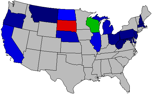 )
)
Blue-President John Calvin Coolidge of Massachuesetts
Red-Senator Hiram W. Johnson of California
Green-Senator Robert Marion La Follette of Wisconsin
1924 Republican Primaries
(
Blue-President John Calvin Coolidge of Massachuesetts
Red-Senator Hiram W. Johnson of California
Green-Senator Robert Marion La Follette of Wisconsin
Title: Re: National Presidential Primary County and State Maps (1912-2012)
Post by: 🐒Gods of Prosperity🔱🐲💸 on January 22, 2013, 01:10:51 AM
Earlier primaries are on page eight of this thread. The 1996 Democratic primary is on page ten.
with more longer pages, they are now on pgs 5 and 6.
Title: Re: National Presidential Primary County and State Maps (1912-2012)
Post by: Oldiesfreak1854 on December 16, 2013, 12:43:17 PM
Here are maps of what I have been able to find so far for past presidential primaries. I was wondering if anyone could help find more data or if they knew where more data could be found. I've scoured the internet in all the usual places, State SOS and Election board websites, ourcampaigns.com, and online blue books, not to mention sending out probably hundreds of emails, and this is what I've come up with.
I have every primary state back to 1968 filled in (with a couple of exceptions) along with as much caucus data as I can find (most blank states, at least back until 1968, are caucus states and therefore have limited data available). Before 1968, I have much more limited data, but this is very much a work in progress, and I am adding new data as often as I can.
Occasionally you will see a state without variations in shade, which means that I do not know anything more than who won the county. Three states on the 2008 Democratic primary map have results displayed by legislative district rather than by county as this is the only data available (Alaska, Kansas, and North Dakota). North Dakota is also displayed as such on the 2008 Republican primary and 2004 Democratic primary maps. All Alaska maps are in House Districts.
2012 Democratic:
() (http://i405.photobucket.com/albums/pp131/rarohla/2012DemocraticPresidentialPrimariesbyCounty.png)
2012 Republican:
() (http://i405.photobucket.com/albums/pp131/rarohla/2012RepublicanPresidentialPrimariesbyCounty.png)
2008 Democratic:
() (http://i405.photobucket.com/albums/pp131/rarohla/2008DemocraticPartyPresidentialPrimariesbyCountywithAllContests.png)
2008 Republican:
() (http://i405.photobucket.com/albums/pp131/rarohla/2008RepublicanPartyPresidentialPrimariesbyCountywithAllContests.png)
2004 Democratic:
() (http://img34.imageshack.us/img34/3382/gxl.png)
2000 Democratic:
() (http://i405.photobucket.com/albums/pp131/rarohla/2000DemocraticPresidentialPrimariesMapwithAllContests.png)
2000 Republican:
() (http://i405.photobucket.com/albums/pp131/rarohla/2000RepublicanPartyPresidentialPrimarieswithAllContests.png)
1996 Democratic:
() (http://i405.photobucket.com/albums/pp131/rarohla/1996DemocraticPresidentialPrimaries.png)
1996 Republican:
() (http://i405.photobucket.com/albums/pp131/rarohla/1996RepublicanPrimaryCountyMapwithAllContests.png)
1992 Democratic:
() (http://i405.photobucket.com/albums/pp131/rarohla/1992DemocraticPrimaryCountyMapwithAllContests.png)
1992 Republican:
() (http://i405.photobucket.com/albums/pp131/rarohla/1992RepublicanPresidentialPrimaries.png)
1988 Democratic:
() (http://i405.photobucket.com/albums/pp131/rarohla/1988DemocraticPrimarieswithAllContests.png)
1988 Republican:
() (http://i405.photobucket.com/albums/pp131/rarohla/1988RepublicanPrimarieswithMichiganbyCD.png)
1984 Democratic:
() (http://i405.photobucket.com/albums/pp131/rarohla/1984DemocraticPrimarywithAllContests.png)
1980 Democratic:
() (http://i405.photobucket.com/albums/pp131/rarohla/1980DemocraticPartyPresidentialPrimariesbyCountywithMICaucusbyCD.png)
1980 Republican:
() (http://i405.photobucket.com/albums/pp131/rarohla/1980RepublicanPresidentialPrimariesbyCounty.png)
1976 Democratic:
() (http://i405.photobucket.com/albums/pp131/rarohla/1976DemocraticPrimariesMap.png)
1976 Republican:
() (http://i405.photobucket.com/albums/pp131/rarohla/1976RepublicanPrimaryCountyMap.png)
1972 Democratic:
() (http://i405.photobucket.com/albums/pp131/rarohla/1972DemocraticPresidentialPrimaries.png)
1968 Democratic:
() (http://i405.photobucket.com/albums/pp131/rarohla/1968DemocraticPresidentialPrimaries.png)
1964 Democratic:
() (http://i405.photobucket.com/albums/pp131/rarohla/1964DemocraticPresidentialPrimariesbyCounty.png)
1964 Republican:
() (http://i405.photobucket.com/albums/pp131/rarohla/1964RPrim.png)
Some older maps:
1952 Republican:
() (http://i405.photobucket.com/albums/pp131/rarohla/1952RepublicanPresidentialPrimariesbyCounty.png)
1948 Republican:
() (http://i405.photobucket.com/albums/pp131/rarohla/1948RepublicanPresidentialPrimaries.png)
1924 Republican:
() (http://i405.photobucket.com/albums/pp131/rarohla/1924RepublicanPresidentialPrimaries.png)
1920 Republican:
() (http://i405.photobucket.com/albums/pp131/rarohla/1920RepublicanPresidentialPrimariesbyCounty.png)
1916 Republican:
() (http://i405.photobucket.com/albums/pp131/rarohla/1916RepublicanPresidentialPrimaries.png)
1912 Democratic:
() (http://i405.photobucket.com/albums/pp131/rarohla/1912DemocraticPartyPrimariesbyCounty.png)
1912 Republican:
() (http://i405.photobucket.com/albums/pp131/rarohla/1912RepublicanPartyPrimariesbyCounty.png)
Title: Re: National Presidential Primary County and State Maps (1912-2012)
Post by: FEMA Camp Administrator on December 16, 2013, 04:04:42 PM
Oldies, bro. I'm beggin' ya. Don't quote that huge thing. It's Hell to scroll through.
Title: Re: National Presidential Primary County and State Maps (1912-2012)
Post by: Lephead on May 03, 2014, 07:05:01 PM
For 2008, I was able to get early results and later results for Spokane County, and it was interesting how Romney was leading, but once he dropped out, his votes dropped like a rock.
Title: Re: National Presidential Primary County and State Maps (1912-2012)
Post by: Senate Minority Leader Lord Voldemort on July 23, 2014, 11:52:48 PM
What happened to North Dakota in the 1996 Democratic primary?
Title: Re: National Presidential Primary County and State Maps (1912-2012)
Post by: RI on July 24, 2014, 03:30:42 PM
What happened to North Dakota in the 1996 Democratic primary?
Clinton wasn't on the ballot. I'm not entirely sure why.
EDIT: I don't think Miles' 2008 NC Dem precinct map has been posted in this thread yet:
() (http://www.pictureshack.us/images/41331_NC2008PDF.png)
Title: Re: National Presidential Primary County and State Maps (1912-2012)
Post by: homelycooking on January 19, 2015, 09:06:58 AM
()
Romney won the city of Columbus by less than ten votes.
Romney won the city of Columbus by less than ten votes.
Title: Re: National Presidential Primary County and State Maps (1912-2012)
Post by: 🐒Gods of Prosperity🔱🐲💸 on January 20, 2015, 12:13:21 AM
really cool. I wonder if Ward and Trimble townships are especially libertarian. What's up with the one Gingrich precinct?
Title: Re: National Presidential Primary County and State Maps (1912-2012)
Post by: ElectionsGuy on January 20, 2015, 05:44:42 AM
When looking at these primary maps, its almost as if Obama/Clinton and Romney/Santorum look like the same urban/rural split.
Title: Re: National Presidential Primary County and State Maps (1912-2012)
Post by: homelycooking on January 20, 2015, 11:56:29 AM
When looking at these primary maps, its almost as if Obama/Clinton and Romney/Santorum look like the same urban/rural split.
It's not so much an urban/rural cleavage in the Republican primary so much as it is a suburban/rural divide. Santorum polled quite well in the big cities - he won Dayton and Toledo and came very close to beating Romney in Columbus. Income and religion are, I think, the two most relevant cleavages to explaining the divide.
really cool. I wonder if Ward and Trimble townships are especially libertarian. What's up with the one Gingrich precinct?
I think that's just an anomalous result in a part of the state in which Gingrich's achieved his best results - in the rural vicinity of Dayton. There's nothing particularly unusual about Perry Township (52 votes for Gingrich, 44 Santorum, 43 Romney, 13 Paul).
Title: Re: National Presidential Primary County and State Maps (1912-2012)
Post by: 🐒Gods of Prosperity🔱🐲💸 on January 20, 2015, 03:15:54 PM
How would religion be an explaining factor? It looks like Santorum did well among Catholics in the northwest, not so much around Cincinnati and Cleveland.
Title: Re: National Presidential Primary County and State Maps (1912-2012)
Post by: homelycooking on January 21, 2015, 07:53:48 AM
Yeah, that wasn't right at all. It's actually pretty astonishing how small of a role religion played in this primary.
Title: Re: National Presidential Primary County and State Maps (1912-2012)
Post by: Rockefeller GOP on January 21, 2015, 01:01:37 PM
Re: the 2008 Democratic map - it seems like you can really pick out where the Dixiecrat vote was/is still strong (WV, AR, Northern Alabama, OK, KY, etc.), in that they massively favored Clinton, and you can see where most White voters seem to have just become 100% Republicans (MS, Southern Alabama, SC, etc.).
Title: Re: National Presidential Primary County and State Maps (1912-2012)
Post by: Mr. Illini on February 16, 2015, 10:20:48 PM
Here's a fun map. This is the 2012 primaries if the non-Paul anti-Romney vote were consolidated behind one candidate.
() (http://i405.photobucket.com/albums/pp131/rarohla/2012RPrimwithconsolidatedanti-Romneyvote.png)
For those who don't know, the actual county map for 2012 is in the OP.
() (http://i405.photobucket.com/albums/pp131/rarohla/2012RPrimwithconsolidatedanti-Romneyvote.png)
For those who don't know, the actual county map for 2012 is in the OP.
Really cool...look at those metro areas! Really highlights a cultural divide in the GOP!
Title: Re: National Presidential Primary County and State Maps (1912-2012)
Post by: RI on September 01, 2015, 01:41:45 PM
2012 Wisconsin R Primary by Ward
() (http://imgur.com/WJB25oI.png)
Romney won Milwaukee 43.90%-35.14%. (14.04% for Paul).
Santorum won Madison 37.70%-32.37% (19.93% for Paul).
() (http://imgur.com/WJB25oI.png)
Romney won Milwaukee 43.90%-35.14%. (14.04% for Paul).
Santorum won Madison 37.70%-32.37% (19.93% for Paul).
Title: Re: National Presidential Primary County and State Maps (1912-2012)
Post by: Oldiesfreak1854 on September 23, 2015, 11:18:08 AM
Where do you get all these state precinct maps from? Dave's Redistricting?
Title: Re: National Presidential Primary County and State Maps (1912-2012)
Post by: RI on September 23, 2015, 01:02:08 PM
Where do you get all these state precinct maps from? Dave's Redistricting?
I generally try to find shapefiles based on the current maps; it's easiest to do it close to the election you want to map.
The shapefiles sometimes need to be edited to fit the results; the Wisconsin ward results merged about 3,000 wards (just under half), so I took a ward shapefile from the WI legislature's website and merged a ton of wards together in ArcGIS.
Title: Re: National Presidential Primary County and State Maps (1912-2012)
Post by: Oldiesfreak1854 on October 07, 2015, 10:47:42 AM
Where do you get all these state precinct maps from? Dave's Redistricting?
I generally try to find shapefiles based on the current maps; it's easiest to do it close to the election you want to map.
The shapefiles sometimes need to be edited to fit the results; the Wisconsin ward results merged about 3,000 wards (just under half), so I took a ward shapefile from the WI legislature's website and merged a ton of wards together in ArcGIS.
Title: Re: National Presidential Primary County and State Maps (1912-2012)
Post by: Miles on October 07, 2015, 01:49:00 PM
^ The Census Bureau has a good shapefile archive. (https://www.census.gov/cgi-bin/geo/shapefilesrd13/main)
Title: Re: National Presidential Primary County and State Maps (1912-2012)
Post by: Oldiesfreak1854 on October 07, 2015, 03:41:25 PM
^ The Census Bureau has a good shapefile archive. (https://www.census.gov/cgi-bin/geo/shapefilesrd13/main)
Title: Re: National Presidential Primary County and State Maps (1912-2012)
Post by: RI on October 07, 2015, 08:04:24 PM
^ The Census Bureau has a good shapefile archive. (https://www.census.gov/cgi-bin/geo/shapefilesrd13/main)
Easiest way is probably to download a free GIS program, open the shapefile, then print screen it.
Title: Re: National Presidential Primary County and State Maps (1912-2012)
Post by: RI on November 20, 2015, 02:32:57 AM
2000 Reform Party Presidential Primaries, AKA Donald Trump's first run for the White House:
() (https://uselectionatlas.org/FORUM/GALLERY/2947_20_11_15_2_32_03.png)
Edit: Also updated the 1916 R Primary to include Montana. Teddy Roosevelt managed to win Missoula County as a write-in.
Edit 2: 1964 Florida Rep Primary added
() (https://uselectionatlas.org/FORUM/GALLERY/2947_20_11_15_2_32_03.png)
Edit: Also updated the 1916 R Primary to include Montana. Teddy Roosevelt managed to win Missoula County as a write-in.
Edit 2: 1964 Florida Rep Primary added
Title: Re: National Presidential Primary County and State Maps (1912-2012)
Post by: RI on January 05, 2016, 02:26:36 PM
Added 1912 Nebraska for both parties
Title: Re: National Presidential Primary County and State Maps (1912-2016)
Post by: RI on February 02, 2016, 02:58:00 PM
2016 Iowa Republican caucus by precinct (Trump blue, Cruz yellow, Rubio green, Carson purple, Fiorina red, Santorum orange):
() (http://imgur.com/XT9aZ68.png)
() (http://imgur.com/XT9aZ68.png)
Title: Re: National Presidential Primary County and State Maps (1912-2016)
Post by: RI on February 02, 2016, 11:25:25 PM
2016 Iowa Democratic caucus by precinct
() (http://i.imgur.com/Ourvlud.png)
() (http://i.imgur.com/Ourvlud.png)
Title: Re: National Presidential Primary County and State Maps (1912-2016)
Post by: Linus Van Pelt on February 03, 2016, 09:05:36 PM
Nice work!
Is that an O'Malley precinct in purple in one of the north-central towns? (maybe Algona, eyeballing a comparison to Google maps)
Is that an O'Malley precinct in purple in one of the north-central towns? (maybe Algona, eyeballing a comparison to Google maps)
Title: Re: National Presidential Primary County and State Maps (1912-2016)
Post by: RI on February 04, 2016, 12:54:21 PM
Nice work!
Is that an O'Malley precinct in purple in one of the north-central towns? (maybe Algona, eyeballing a comparison to Google maps)
Is that an O'Malley precinct in purple in one of the north-central towns? (maybe Algona, eyeballing a comparison to Google maps)
It's listed as Uncommitted winning the one delegate in that precinct, actually. I don't think O'Malley won any precincts.
Title: Re: National Presidential Primary County and State Maps (1912-2016)
Post by: Fuzzybigfoot on February 04, 2016, 05:28:22 PM
Awesome! Have you calculated the results by congressional district yet?
Title: Re: National Presidential Primary County and State Maps (1912-2016)
Post by: Miles on February 04, 2016, 05:43:43 PM
Awesome! Have you calculated the results by congressional district yet?
Over here. (https://uselectionatlas.org/FORUM/index.php?topic=228104)
Title: Re: National Presidential Primary County and State Maps (1912-2016)
Post by: homelycooking on February 08, 2016, 02:40:20 PM
I calculated the GOP results for the 39 Iowa cities with a population greater than 10,000. Here they are listed in descending order of population. Yellow: Cruz, Red: Trump, Pink: Rubio.
Des Moines
Cedar Rapids
Davenport
Sioux City
Iowa City
Waterloo
Council Bluffs
Ames
West Des Moines
Dubuque
Ankeny
Urbandale
Cedar Falls
Marion
Bettendorf
Marshalltown
Mason City
Clinton
Burlington
Ottumwa
Fort Dodge
Muscatine
Coralville
Johnston
Clive
Altoona
Newton
Indianola
Waukee
North Liberty
Boone
Oskaloosa
Spencer
Fort Madison
Storm Lake
Keokuk
Pella
Waverly
Carroll
Title: Re: National Presidential Primary County and State Maps (1912-2016)
Post by: homelycooking on February 08, 2016, 02:58:39 PM
The candidates' top five cities:
CRUZ
1 Boone 31.7%
2 Altoona 31.1%
3 Pella 30.0%
4 Waterloo 29.8%
5 Oskaloosa 29.6%
TRUMP
1 Council Bluffs 36.6%
2 Ottumwa 33.7%
3 Burlington 31.5%
4 Clinton 31.1%
5 Muscatine 30.8%
RUBIO
1 Clive 38.3%
2 Ames 37.9%
3 Iowa City 36.9%
4 Waukee 36.5%
5 Cedar Falls 35.0%
CARSON
1 Spencer 14.3%
2 Keokuk 14.0%
3 Oskaloosa 12.4%
4 Council Bluffs 12.2%
5 Pella 11.2%
PAUL
1 Iowa City 13.1%
2 Ames 10.2%
3 North Liberty 9.0%
4 Dubuque 8.1%
5 Cedar Rapids 7.1%
BUSH
1 Carroll 7.6%
2 West Des Moines 5.8%
3 Clinton 5.7%
4 Des Moines 5.5%
5 Mason City 5.2%
FIORINA
1 Keokuk 7.2%
2 Carroll 5.5%
3 Clinton 3.8%
4 Marion 3.4%
5 Coralville 3.1%
KASICH
1 Bettendorf 6.6%
2 Iowa City 5.0%
3 Council Bluffs 4.6%
4 Clive 4.1%
5 Davenport 4.0%
HUCKABEE
1 Ottumwa 6.4%
2 Fort Dodge 4.6%
3 Boone 3.9%
4 Keokuk 3.4%
5 Altoona 2.9%
CHRISTIE
1 Fort Dodge 6.4%
2 Boone 4.1%
3 Clive 3.7%
4 West Des Moines 3.4%
5 Mason City 3.4%
SANTORUM
1 Storm Lake 3.7%
2 Sioux City 3.6%
3 Marshalltown 3.1%
4 Indianola 2.4%
5 Waverly 2.1%
Title: Re: National Presidential Primary County and State Maps (1912-2016)
Post by: RI on February 10, 2016, 02:47:54 PM
2016 NH Town Maps (Kasich is red on the rightward map):
()
()
Title: Re: National Presidential Primary County and State Maps (1912-2016)
Post by: RI on February 11, 2016, 02:21:41 AM
Comparing vote totals across parties:
() (https://uselectionatlas.org/FORUM/GALLERY/2947_11_02_16_2_20_54.png)
() (https://uselectionatlas.org/FORUM/GALLERY/2947_11_02_16_2_20_54.png)
Title: Re: National Presidential Primary County and State Maps (1912-2016)
Post by: homelycooking on February 12, 2016, 10:53:57 PM
()
Title: Re: National Presidential Primary County and State Maps (1912-2016)
Post by: RI on February 16, 2016, 11:47:20 AM
Using the same color scale, here's Iowa by Senate District:
() (https://uselectionatlas.org/FORUM/GALLERY/2947_16_02_16_11_46_30.png)
Title: Re: National Presidential Primary County and State Maps (1912-2016)
Post by: RI on February 16, 2016, 01:01:47 PM
I made some minor candidate Iowa maps to try and show where each candidate's best and worst areas were. They aren't meant to be compared to each other directly.
Rand Paul:
() (https://uselectionatlas.org/FORUM/GALLERY/2947_16_02_16_12_56_25.png)
Jeb Bush:
() (https://uselectionatlas.org/FORUM/GALLERY/2947_16_02_16_12_57_25.png)
Carly Fiorina:
() (https://uselectionatlas.org/FORUM/GALLERY/2947_16_02_16_12_57_58.png)
John Kasich:
() (https://uselectionatlas.org/FORUM/GALLERY/2947_16_02_16_12_59_38.png)
Mike Huckabee:
() (https://uselectionatlas.org/FORUM/GALLERY/2947_16_02_16_1_00_29.png)
Chris Christie:
() (https://uselectionatlas.org/FORUM/GALLERY/2947_16_02_16_1_00_56.png)
Rick Santorum:
() (https://uselectionatlas.org/FORUM/GALLERY/2947_16_02_16_1_01_23.png)
Title: Re: National Presidential Primary County and State Maps (1912-2016)
Post by: RI on February 16, 2016, 01:39:08 PM
Going forward, would you prefer a map like this:
() (https://uselectionatlas.org/FORUM/GALLERY/2947_16_02_16_1_38_08.png)
or like this:
() (https://uselectionatlas.org/FORUM/GALLERY/2947_16_02_16_1_38_49.png)
() (https://uselectionatlas.org/FORUM/GALLERY/2947_16_02_16_1_38_08.png)
or like this:
() (https://uselectionatlas.org/FORUM/GALLERY/2947_16_02_16_1_38_49.png)
Title: Re: National Presidential Primary County and State Maps (1912-2016)
Post by: This account no longer in use. on February 16, 2016, 03:46:59 PM
I, personally, would prefer county lines.
Title: Re: National Presidential Primary County and State Maps (1912-2016)
Post by: RI on February 16, 2016, 07:29:32 PM
Dem caucus by Senate District:
() (https://uselectionatlas.org/FORUM/GALLERY/2947_16_02_16_7_28_58.png)
() (https://uselectionatlas.org/FORUM/GALLERY/2947_16_02_16_7_28_58.png)
Title: Re: National Presidential Primary County and State Maps (1912-2016)
Post by: RI on February 17, 2016, 01:09:12 PM
Here's the Dem equivalent of the above national maps:
() (https://uselectionatlas.org/FORUM/GALLERY/2947_17_02_16_1_07_42.png)
() (https://uselectionatlas.org/FORUM/GALLERY/2947_17_02_16_1_08_48.png)
() (https://uselectionatlas.org/FORUM/GALLERY/2947_17_02_16_1_07_42.png)
() (https://uselectionatlas.org/FORUM/GALLERY/2947_17_02_16_1_08_48.png)
Title: Re: National Presidential Primary County and State Maps (1912-2016)
Post by: Miles on February 21, 2016, 01:20:05 PM
Charleston County. I have Bush winning a precinct, but it was just because of my absentee allocation formula:
()
()
Title: Re: National Presidential Primary County and State Maps (1912-2016)
Post by: Miles on February 21, 2016, 04:45:49 PM
Richland and Lexington Counties:
()
()
Title: Re: National Presidential Primary County and State Maps (1912-2016)
Post by: RI on February 21, 2016, 05:14:57 PM
I'll have a statewide precinct map up soon, though its color scheme isn't as variegated as yours, and I didn't allocate any of the absentees.
Title: Re: National Presidential Primary County and State Maps (1912-2016)
Post by: RI on February 21, 2016, 07:11:41 PM
Same color scheme; Bush is orange:
() (https://uselectionatlas.org/FORUM/GALLERY/2947_21_02_16_7_07_31.png)
Non-Trump vote:
() (https://uselectionatlas.org/FORUM/GALLERY/2947_21_02_16_7_08_10.png)
Relative strength maps:
() (https://uselectionatlas.org/FORUM/GALLERY/2947_21_02_16_7_09_03.png)
() (https://uselectionatlas.org/FORUM/GALLERY/2947_21_02_16_7_09_37.png)
Updated national maps:
() (https://uselectionatlas.org/FORUM/GALLERY/2947_21_02_16_7_10_25.png)
() (https://uselectionatlas.org/FORUM/GALLERY/2947_21_02_16_7_10_58.png)
Title: Re: National Presidential Primary County and State Maps (1912-2016)
Post by: / on February 21, 2016, 07:38:17 PM
Very nice!
Title: Re: National Presidential Primary County and State Maps (1912-2016)
Post by: Miles on February 21, 2016, 07:38:44 PM
What year is the SC shapefile from? The most recent I can find is 2013?
Title: Re: National Presidential Primary County and State Maps (1912-2016)
Post by: RI on February 21, 2016, 07:43:07 PM
What year is the SC shapefile from? The most recent I can find is 2013?
We probably used the same one, then. Most of the precincts didn't change, but I went through and did my best to match up the ones that did change and merged a number of precincts together.
Title: Re: National Presidential Primary County and State Maps (1912-2016)
Post by: Miles on February 21, 2016, 07:45:46 PM
^ Thanks!
Title: Re: National Presidential Primary County and State Maps (1912-2016)
Post by: JerryArkansas on February 21, 2016, 10:00:03 PM
Realist, you want the Congressional map that I've started posted on here?
Title: Re: National Presidential Primary County and State Maps (1912-2016)
Post by: RI on February 21, 2016, 10:23:28 PM
Realist, you want the Congressional map that I've started posted on here?
You're welcome to post it.
Title: Re: National Presidential Primary County and State Maps (1912-2016)
Post by: JerryArkansas on February 21, 2016, 10:41:59 PM
()
()
()
Title: Re: National Presidential Primary County and State Maps (1912-2016)
Post by: RI on February 22, 2016, 08:57:55 PM
With all precincts reporting, the CD breakdown for the Nevada Dem caucus:
NV-01: Clinton 1632 (52.94%), Sanders 1451 (47.06%)
NV-02: Sanders 1561 (54.28%), Clinton 1311 (45.58%), Uncom 4 (0.14%)
NV-03: Clinton 1560 (52.60%), Sanders 1405 (47.37%), Uncom 1 (0.03%)
NV-04: Clinton 1937 (58.56%), Sanders 1368 (41.35%), Uncom 3 (0.09%)
NV-01: Clinton 1632 (52.94%), Sanders 1451 (47.06%)
NV-02: Sanders 1561 (54.28%), Clinton 1311 (45.58%), Uncom 4 (0.14%)
NV-03: Clinton 1560 (52.60%), Sanders 1405 (47.37%), Uncom 1 (0.03%)
NV-04: Clinton 1937 (58.56%), Sanders 1368 (41.35%), Uncom 3 (0.09%)
Title: Re: National Presidential Primary County and State Maps (1912-2016)
Post by: / on February 22, 2016, 09:09:20 PM
@JerryArkansas:
Great maps, but imgur hasn't been working on Atlas recently so they don't show up. Here they are in a better-functioning format:
()
()
Great maps, but imgur hasn't been working on Atlas recently so they don't show up. Here they are in a better-functioning format:
()
()
Title: Re: National Presidential Primary County and State Maps (1912-2016)
Post by: RI on February 22, 2016, 09:39:31 PM
Las Vegas area Dem caucus by Assembly District (grey is tied):
() (https://uselectionatlas.org/FORUM/GALLERY/2947_22_02_16_9_39_08.png)
() (https://uselectionatlas.org/FORUM/GALLERY/2947_22_02_16_9_39_08.png)
Title: Re: National Presidential Primary County and State Maps (1912-2016)
Post by: RI on February 23, 2016, 01:06:01 PM
Nevada Dem caucus:
() (https://uselectionatlas.org/FORUM/GALLERY/2947_23_02_16_1_01_37.png)
Without lines:
() (https://uselectionatlas.org/FORUM/GALLERY/2947_23_02_16_1_02_17.png)
Las Vegas inset:
() (https://uselectionatlas.org/FORUM/GALLERY/2947_23_02_16_1_02_59.png)
Reno inset:
() (https://uselectionatlas.org/FORUM/GALLERY/2947_23_02_16_1_03_22.png)
National:
() (https://uselectionatlas.org/FORUM/GALLERY/2947_23_02_16_1_04_00.png)
() (https://uselectionatlas.org/FORUM/GALLERY/2947_23_02_16_1_04_27.png)
Title: Re: National Presidential Primary County and State Maps (1912-2016)
Post by: Fuzzybigfoot on February 24, 2016, 06:06:25 AM
Is that purple precinct in Clarke County for O'Malley? :P
Title: Re: National Presidential Primary County and State Maps (1912-2016)
Post by: RI on February 24, 2016, 11:08:36 AM
Is that purple precinct in Clarke County for O'Malley? :P
Nah, Uncommitted. O'Malley hasn't won anything.
Title: Re: National Presidential Primary County and State Maps (1912-2016)
Post by: RI on February 25, 2016, 04:00:33 PM
Nevada GOP results by CD:
NV-01: Trump 53.19%, Rubio 20.44%, Cruz 18.97%, Carson 3.99%, Kasich 2.95%
NV-02: Trump 41.59%, Cruz 24.00%, Rubio 23.62%, Carson 6.25%, Kasich 4.04%
NV-03: Trump 49.75%, Rubio 25.58%, Cruz 17.54%, Kasich 3.72%, Carson 3.05%
NV-04: Trump 45.96%, Rubio 23.55%, Cruz 22.39%, Carson 4.72%, Kasich 2.92%
Las Vegas: Trump 50.44%, Rubio 23.95%, Cruz 18.50%, Carson 3.37%, Kasich 3.37%
North Las Vegas: Trump 47.00%, Cruz 22.86%, Rubio 22.03%, Carson 4.94%, Kasich 2.72%
Henderson: Trump 47.78%, Rubio 25.78%, Cruz 18.90%, Kasich 3.76%, Carson 3.44%
Boulder City: Trump 41.66%, Rubio 30.24%, Cruz 19.71%, Carson 4.00%, Kasich 3.71%
Laughlin: Trump 56.73%, Rubio 21.64%, Cruz 12.57%, Carson 4.97%, Kasich 3.22%
Moapa: Cruz 48.57%, Trump 31.43%, Rubio 14.29%, Carson 5.71%
Moapa Valley: Cruz 38.19%, Rubio 28.40%, Trump 22.20%, Carson 8.11%, Kasich 2.39%
Bunkerville: Rubio 34.78%, Cruz 33.33%, Trump 23.19%, Carson 8.70%
Mesquite: Trump 43.07%, Rubio 30.59%, Cruz 17.73%, Carson 5.37%, Kasich 3.00%
Searchlight: Trump 60.00%, Cruz 33.33%, Rubio 6.67%
Title: Re: National Presidential Primary County and State Maps (1912-2016)
Post by: RI on February 25, 2016, 04:22:14 PM
Borrowing Miles's color scheme, here's the Las Vegas area by Assembly District (Trump won all of them):
() (https://uselectionatlas.org/FORUM/GALLERY/2947_25_02_16_4_21_33.png)
() (https://uselectionatlas.org/FORUM/GALLERY/2947_25_02_16_4_21_33.png)
Title: Re: National Presidential Primary County and State Maps (1912-2016)
Post by: RI on February 26, 2016, 12:09:52 PM
NV GOP Caucus:
() (https://uselectionatlas.org/FORUM/GALLERY/2947_26_02_16_12_06_34.png)
() (https://uselectionatlas.org/FORUM/GALLERY/2947_26_02_16_12_07_15.png)
() (https://uselectionatlas.org/FORUM/GALLERY/2947_26_02_16_12_07_53.png)
National:
() (https://uselectionatlas.org/FORUM/GALLERY/2947_26_02_16_12_08_32.png)
() (https://uselectionatlas.org/FORUM/GALLERY/2947_26_02_16_12_09_06.png)
Title: Re: National Presidential Primary County and State Maps (1912-2016)
Post by: homelycooking on February 26, 2016, 08:48:54 PM
New Hampshire with city wards.
()
()
Title: Re: National Presidential Primary County and State Maps (1912-2016)
Post by: 🐒Gods of Prosperity🔱🐲💸 on February 27, 2016, 02:27:02 AM
beautiful Nevada GOP map, I've been looking forward to seeing that. What are the gray areas?
doesn't seem to be showing up. maybe you can upload it to the gallery?
New Hampshire with city wards.
()
()
Title: Re: National Presidential Primary County and State Maps (1912-2016)
Post by: RI on February 27, 2016, 02:48:17 AM
beautiful Nevada GOP map, I've been looking forward to seeing that. What are the gray areas?
Dark grey precincts are ties, light grey precincts have zero votes.
Title: Re: National Presidential Primary County and State Maps (1912-2016)
Post by: homelycooking on February 27, 2016, 01:22:56 PM
Try this one, shua. The original image is too large for the gallery.
()
()
Title: Re: National Presidential Primary County and State Maps (1912-2016)
Post by: RI on February 28, 2016, 05:16:02 PM
SC Dem primary:
() (https://uselectionatlas.org/FORUM/GALLERY/2947_28_02_16_5_09_55.png)
National:
() (https://uselectionatlas.org/FORUM/GALLERY/2947_28_02_16_5_15_04.png)
() (https://uselectionatlas.org/FORUM/GALLERY/2947_28_02_16_5_15_43.png)
() (https://uselectionatlas.org/FORUM/GALLERY/2947_28_02_16_5_09_55.png)
National:
() (https://uselectionatlas.org/FORUM/GALLERY/2947_28_02_16_5_15_04.png)
() (https://uselectionatlas.org/FORUM/GALLERY/2947_28_02_16_5_15_43.png)
Title: Re: National Presidential Primary County and State Maps (1912-2016)
Post by: Fuzzybigfoot on February 28, 2016, 05:21:17 PM
That's insane. Can I share the precinct map on our Facebook? I'll be sure to credit you!
Title: Re: National Presidential Primary County and State Maps (1912-2016)
Post by: RI on February 28, 2016, 05:24:39 PM
Can I share the precinct map on our Facebook? I'll be sure to credit you!
Sure
Title: Re: National Presidential Primary County and State Maps (1912-2016)
Post by: RI on March 02, 2016, 02:48:44 PM
() (https://uselectionatlas.org/FORUM/GALLERY/2947_02_03_16_2_47_40.png)
() (https://uselectionatlas.org/FORUM/GALLERY/2947_02_03_16_2_48_21.png)
() (https://uselectionatlas.org/FORUM/GALLERY/2947_02_03_16_2_48_21.png)
Title: Re: National Presidential Primary County and State Maps (1912-2016)
Post by: homelycooking on March 02, 2016, 04:29:59 PM
()
Title: Re: National Presidential Primary County and State Maps (1912-2016)
Post by: / on March 02, 2016, 04:37:04 PM
Do we have a nationwide shaded county map yet? If not, I'd be willing to make one.
Title: Re: National Presidential Primary County and State Maps (1912-2016)
Post by: RI on March 02, 2016, 05:03:57 PM
Do we have a nationwide shaded county map yet? If not, I'd be willing to make one.
I've been waiting on the last few counties to come in before I update my map in the OP.
EDIT: Both have been updated.
Title: Re: National Presidential Primary County and State Maps (1912-2016)
Post by: Fuzzybigfoot on March 02, 2016, 06:50:50 PM
I'm interested to see how TX-35 (Austin) turned out, since that was the only major city to vote for Sanders. I'd also love to see if Cruz swept the Dallas area in number of congressional districts won.
Title: Re: National Presidential Primary County and State Maps (1912-2016)
Post by: RBH on March 02, 2016, 07:42:33 PM
I'm interested to see how TX-35 (Austin) turned out, since that was the only major city to vote for Sanders. I'd also love to see if Cruz swept the Dallas area in number of congressional districts won.
Texas Democrats don't allocate their delegates by Congressional district. They allocate delegates by Texas Senate district.
Clinton won 29 of 31 Texas Senate districts. The only districts carried by Sanders: SD14 (Austin, represented by Kirk Watson) and SD30 (Northwest of DFW, going to Wichita Falls, represented by Republican Craig Estes)
In the 11 districts represented by Democrats, Clinton won 67-31. Delegates: Clinton 45, Sanders 20
In the 20 districts represented by Republicans, Clinton won 64-35. Delegates: Clinton 50, Sanders 30
Title: Re: National Presidential Primary County and State Maps (1912-2016)
Post by: RI on March 02, 2016, 09:05:33 PM
Interesting that the only sizable clump of Cruz precincts in Virginia is clustered around Lynchburg (ie Liberty University).
Cruz won every CD in Texas.
I'd also love to see if Cruz swept the Dallas area in number of congressional districts won.
Cruz won every CD in Texas.
Title: Re: National Presidential Primary County and State Maps (1912-2016)
Post by: / on March 02, 2016, 10:11:57 PM
Rubio vs. Cruz:
()
()
Title: Re: National Presidential Primary County and State Maps (1912-2016)
Post by: Fuzzybigfoot on March 02, 2016, 11:57:16 PM
Interesting that the only sizable clump of Cruz precincts in Virginia is clustered around Lynchburg (ie Liberty University).
Cruz won every CD in Texas.
I'd also love to see if Cruz swept the Dallas area in number of congressional districts won.
Cruz won every CD in Texas.
Atlas showed Rubio winning TX-33, but now I can't get it the map.
Title: Re: National Presidential Primary County and State Maps (1912-2016)
Post by: JerryArkansas on March 03, 2016, 01:43:38 AM
Congressional Results maps after Super Tuesday
()
*Note I do not have results for MA broken-down by congressional district
()
In states not yet done reporting results, shading might be somewhat off.
()
*Note I do not have results for MA broken-down by congressional district
()
In states not yet done reporting results, shading might be somewhat off.
Title: Re: National Presidential Primary County and State Maps (1912-2016)
Post by: Mr. Morden on March 03, 2016, 02:02:08 AM
Hey, this thread is famous. It got retweeted by NYT's Nate Cohn:
https://twitter.com/Nate_Cohn/status/705219801300537344
https://twitter.com/Nate_Cohn/status/705219801300537344
Title: Re: National Presidential Primary County and State Maps (1912-2016)
Post by: / on March 03, 2016, 02:03:54 AM
Hey, this thread is famous. It got retweeted by NYT's Nate Cohn:
https://twitter.com/Nate_Cohn/status/705219801300537344
https://twitter.com/Nate_Cohn/status/705219801300537344
ayy
Title: Re: National Presidential Primary County and State Maps (1912-2016)
Post by: The Free North on March 03, 2016, 09:30:15 AM
Hey, this thread is famous. It got retweeted by NYT's Nate Cohn:
https://twitter.com/Nate_Cohn/status/705219801300537344
https://twitter.com/Nate_Cohn/status/705219801300537344
ayy
Come post with us Nate Cohn!
We have maps!
And Maps!
Title: Re: National Presidential Primary County and State Maps (1912-2016)
Post by: RI on March 03, 2016, 05:48:40 PM
() (https://uselectionatlas.org/FORUM/GALLERY/2947_03_03_16_5_47_24.png)
() (https://uselectionatlas.org/FORUM/GALLERY/2947_03_03_16_5_48_11.png)
() (https://uselectionatlas.org/FORUM/GALLERY/2947_03_03_16_5_48_11.png)
Title: Re: National Presidential Primary County and State Maps (1912-2016)
Post by: Antonio the Sixth on March 03, 2016, 05:58:07 PM
Bernie losing VA-9 is frankly unforgivable.
Title: Re: National Presidential Primary County and State Maps (1912-2016)
Post by: Bismarck on March 03, 2016, 06:28:34 PM
Anybody else notice the correlation between Trump vote and living by a river in Iowa and Arkansas? I believe if there was a competitive race by the time Indiana rolled around Trump would also do well in the lower wabash valley region.
Title: Re: National Presidential Primary County and State Maps (1912-2016)
Post by: RI on March 04, 2016, 01:58:19 PM
() (https://uselectionatlas.org/FORUM/GALLERY/2947_04_03_16_1_57_54.png)
() (https://uselectionatlas.org/FORUM/GALLERY/2947_04_03_16_1_57_07.png)
() (https://uselectionatlas.org/FORUM/GALLERY/2947_04_03_16_1_57_07.png)
Title: Re: National Presidential Primary County and State Maps (1912-2016)
Post by: Adam Griffin on March 04, 2016, 08:09:47 PM
Very nice! What shapefile are you using for Georgia, and how on God's green earth did you find one that is completely up-to-date for this week's results? It seems like at least a dozen counties change their precinct boundaries in some capacity every single year and I've never come across one that seems to be completely accurate for any particular election. Even on the GA reapportionment page, they only have the 2014 shapefile (and that one was just added in the past couple of months).
Title: Re: National Presidential Primary County and State Maps (1912-2016)
Post by: homelycooking on March 04, 2016, 08:32:28 PM
Leading opposition to Trump, by town. Kasich in blue, Rubio (appropriately!) in red, Bush in brown and Cruz in yellow.
()
Congratulations to realistic for his superior work in this thread.
()
Congratulations to realistic for his superior work in this thread.
Title: Re: National Presidential Primary County and State Maps (1912-2016)
Post by: Antonio the Sixth on March 04, 2016, 09:08:08 PM
Rubio (appropriately!) in red
??? Didn't know he was a commie.
Anyway, this thread is awesome and I just bookmarked it (and slapped myself for not doing that before).
Title: Re: National Presidential Primary County and State Maps (1912-2016)
Post by: RI on March 04, 2016, 11:35:25 PM
Very nice! What shapefile are you using for Georgia, and how on God's green earth did you find one that is completely up-to-date for this week's results? It seems like at least a dozen counties change their precinct boundaries in some capacity every single year and I've never come across one that seems to be completely accurate for any particular election. Even on the GA reapportionment page, they only have the 2014 shapefile (and that one was just added in the past couple of months).
It's very rare that I find a completely up to date shapefile. Generally, I find the most recent one I can and modify it with the editing tools in ArcMap to more closely match maps of current precincts. In this case, I started with the 2014 shapefile you mentioned.
Title: Re: National Presidential Primary County and State Maps (1912-2016)
Post by: RI on March 05, 2016, 11:19:49 AM
() (https://uselectionatlas.org/FORUM/GALLERY/2947_05_03_16_11_18_43.png)
() (https://uselectionatlas.org/FORUM/GALLERY/2947_05_03_16_11_19_30.png)
() (https://uselectionatlas.org/FORUM/GALLERY/2947_05_03_16_11_19_30.png)
Title: Re: National Presidential Primary County and State Maps (1912-2016)
Post by: RI on March 05, 2016, 12:20:33 PM
OK GOP race by House District (different scale):
() (https://uselectionatlas.org/FORUM/GALLERY/2947_05_03_16_12_20_11.png)
() (https://uselectionatlas.org/FORUM/GALLERY/2947_05_03_16_12_20_11.png)
Title: Re: National Presidential Primary County and State Maps (1912-2016)
Post by: homelycooking on March 05, 2016, 09:38:27 PM
()
Title: Re: National Presidential Primary County and State Maps (1912-2016)
Post by: RI on March 06, 2016, 01:15:01 AM
I've updated the OP for today's races, including with the Maine GOP county results and some scattered Kansas GOP county results. The Kansas results for both parties are a work in progress.
EDIT: Found the KS GOP results by county. Unfortunately, they combined a number of counties, so it's not a "true" county map, but it's as close as you can get.
EDIT: Found the KS GOP results by county. Unfortunately, they combined a number of counties, so it's not a "true" county map, but it's as close as you can get.
Title: Re: National Presidential Primary County and State Maps (1912-2016)
Post by: 🐒Gods of Prosperity🔱🐲💸 on March 06, 2016, 02:42:19 AM
I've updated the OP for today's races, including with the Maine GOP county results and some scattered Kansas GOP county results. The Kansas results for both parties are a work in progress.
EDIT: Found the KS GOP results by county. Unfortunately, they combined a number of counties, so it's not a "true" county map, but it's as close as you can get.
EDIT: Found the KS GOP results by county. Unfortunately, they combined a number of counties, so it's not a "true" county map, but it's as close as you can get.
Cool. Where did you find the Maine county results?
Neat to see the little Carson and Kasich precincts around Atlanta. Any idea about what the story is with that large Kasich precinct outside of Augusta?
Title: Re: National Presidential Primary County and State Maps (1912-2016)
Post by: 🐒Gods of Prosperity🔱🐲💸 on March 06, 2016, 02:54:46 AM
() (https://uselectionatlas.org/FORUM/GALLERY/2947_02_03_16_2_47_40.png)
I just noticed - are those some Ben Carson precincts in Portsmouth?
Title: Re: National Presidential Primary County and State Maps (1912-2016)
Post by: RI on March 06, 2016, 11:33:04 AM
Cool. Where did you find the Maine county results?
I found a copy of the slideshow (https://drive.google.com/file/d/0B_W8V6ab5O57TmIwY3I4bDR3dE1jUWJsWGQxQlR1a3U4bDV3/view) they presented at the results announcement party. It has an error in Aroostook County as the numbers on a slide repeat, but you can easily figure out the correct numbers using the overall total.
These are the correct numbers:
()
Quote
Neat to see the little Carson and Kasich precincts around Atlanta. Any idea about what the story is with that large Kasich precinct outside of Augusta?
All of these have really low turnout (single digits) and are generally in supermajority black areas. The large Kasich precinct had exactly one voter. I believe the same is true of the Portsmouth Carson precincts.
Title: Re: National Presidential Primary County and State Maps (1912-2016)
Post by: RI on March 06, 2016, 01:11:15 PM
Here's a slightly more detailed map of Maine
()
()
Title: Re: National Presidential Primary County and State Maps (1912-2016)
Post by: RI on March 06, 2016, 01:38:07 PM
Minnesota GOP caucus by Organizing Unit:
()
()
Title: Re: National Presidential Primary County and State Maps (1912-2016)
Post by: RI on March 06, 2016, 03:13:08 PM
Very strong chance Cruz "won" Colorado on Super Tuesday. While there was no official preference poll, a number of counties did unofficial straw polls. "Officially", Cruz won Larimer, Weld, Adams. Rubio won Boulder and Eagle. Sample of precincts suggests Cruz also won Mesa, El Paso, Douglas, and possibly Jefferson. Arapahoe was too close to call between Cruz and Rubio. Trump came in third most everywhere. Carson may have come in second in El Paso County.
Title: Re: National Presidential Primary County and State Maps (1912-2016)
Post by: 🐒Gods of Prosperity🔱🐲💸 on March 07, 2016, 02:59:10 PM
Quote
Neat to see the little Carson and Kasich precincts around Atlanta. Any idea about what the story is with that large Kasich precinct outside of Augusta?
All of these have really low turnout (single digits) and are generally in supermajority black areas. The large Kasich precinct had exactly one voter. I believe the same is true of the Portsmouth Carson precincts.
Yeah, he got 3 or 4 voters in those precincts. Very black parts of town (as much of Portsmouth is), which couldn't have hurt him either.
Title: Re: National Presidential Primary County and State Maps (1912-2016)
Post by: Miles on March 07, 2016, 08:30:40 PM
Louisiana Republican Primary :D
()
()
Title: Re: National Presidential Primary County and State Maps (1912-2016)
Post by: Miles on March 07, 2016, 11:35:35 PM
A few closer shots of Louisiana:
North
()
South
()
New Orleans metro
()
North
()
South
()
New Orleans metro
()
Title: Re: National Presidential Primary County and State Maps (1912-2016)
Post by: RI on March 08, 2016, 12:28:06 AM
I'm going to attempt something new. Try this on. (https://rarohla.cartodb.com/viz/2ebe2bb6-e4ec-11e5-bc33-0e674067d321/public_map)
Title: Re: National Presidential Primary County and State Maps (1912-2016)
Post by: 🐒Gods of Prosperity🔱🐲💸 on March 08, 2016, 02:17:39 AM
I'm going to attempt something new. Try this on. (https://rarohla.cartodb.com/viz/2ebe2bb6-e4ec-11e5-bc33-0e674067d321/public_map)
Awesome! :D
btw in Norfolk precinct 211, Kasich got 100 votes that were initially mistakenly given to Santorum.
Title: Re: National Presidential Primary County and State Maps (1912-2016)
Post by: RI on March 08, 2016, 11:38:49 AM
Interactive GA and SC GOP map (https://rarohla.cartodb.com/viz/4fae4c52-e54b-11e5-b6b0-0e5db1731f59/public_map)
Title: Re: National Presidential Primary County and State Maps (1912-2016)
Post by: RI on March 08, 2016, 03:59:44 PM
Interactive Arkansas, Oklahoma, Louisiana, and parts of Texas GOP map (https://rarohla.cartodb.com/viz/e850ca4c-e56f-11e5-b819-0ea31932ec1d/public_map)
Title: Re: National Presidential Primary County and State Maps (1912-2016)
Post by: / on March 08, 2016, 04:01:31 PM
Wow realisticidealist, this is great! :D
Title: Re: National Presidential Primary County and State Maps (1912-2016)
Post by: Figueira on March 10, 2016, 09:01:10 AM
Here's a slightly more detailed map of Maine
()
()
Thank you! I've been looking for a map like this.
Title: Re: National Presidential Primary County and State Maps (1912-2016)
Post by: catographer on March 10, 2016, 11:33:37 PM
For Maine, NYT released an interactive Maine county map for the GOP FYI.
Title: Re: National Presidential Primary County and State Maps (1912-2016)
Post by: RI on March 11, 2016, 06:28:34 PM
() (http://www.pictureshack.us/images/59542_MA_R.png)
() (http://www.pictureshack.us/images/29388_MA_D.png)
Boston inset:
() (https://uselectionatlas.org/FORUM/GALLERY/2947_11_03_16_6_49_47.png)
() (https://uselectionatlas.org/FORUM/GALLERY/2947_11_03_16_6_49_04.png)
() (http://www.pictureshack.us/images/29388_MA_D.png)
Boston inset:
() (https://uselectionatlas.org/FORUM/GALLERY/2947_11_03_16_6_49_47.png)
() (https://uselectionatlas.org/FORUM/GALLERY/2947_11_03_16_6_49_04.png)
Title: Re: National Presidential Primary County and State Maps (1912-2016)
Post by: ElectionsGuy on March 12, 2016, 09:22:30 PM
One trend we're seeing that's very interesting is that well-off suburbs and urban areas are going way more to Clinton than Sanders. Even though places right outside Boston are very liberal, high socioeconomic status voters are more pro-establishment, probably because they don't feel the economic pain that people who are in less comfortable positions do. Very liberal places like Hanover, NH and Ann Arbor, MI were much less pro-Bernie than I expected. I honestly expected the Boston area to be much more for Sanders than it was, but the same kind of trend took place in the Detroit area, and I expect the same kind of thing in other metropolitan areas. This primary may be just as much about class as it is about ideology.
Title: Re: National Presidential Primary County and State Maps (1912-2016)
Post by: RI on March 13, 2016, 05:23:01 PM
Hawaii GOP caucus:
() (https://uselectionatlas.org/FORUM/GALLERY/2947_13_03_16_5_21_18.png)
() (https://uselectionatlas.org/FORUM/GALLERY/2947_13_03_16_5_21_51.png)
Kansas Dem caucus by SD:
() (https://uselectionatlas.org/FORUM/GALLERY/2947_13_03_16_5_22_28.png)
() (https://uselectionatlas.org/FORUM/GALLERY/2947_13_03_16_5_21_18.png)
() (https://uselectionatlas.org/FORUM/GALLERY/2947_13_03_16_5_21_51.png)
Kansas Dem caucus by SD:
() (https://uselectionatlas.org/FORUM/GALLERY/2947_13_03_16_5_22_28.png)
Title: Re: National Presidential Primary County and State Maps (1912-2016)
Post by: JerryArkansas on March 13, 2016, 10:30:14 PM
Realist, can you calculate the GOP results by congressional district in MA for me. Hate not having it on the map.
Title: Re: National Presidential Primary County and State Maps (1912-2016)
Post by: RI on March 13, 2016, 10:52:30 PM
Realist, can you calculate the GOP results by congressional district in MA for me. Hate not having it on the map.
Dave has the results on the main site. Trump won every CD:
| District | Trump | Kasich | Rubio | Cruz |
| 1 | 48.59% | 16.69% | 16.06% | 12.19% |
| 2 | 47.65% | 16.64% | 17.38% | 11.77% |
| 3 | 49.59% | 17.14% | 17.52% | 9.61% |
| 4 | 45.07% | 19.99% | 20.79% | 9.12% |
| 5 | 45.73% | 21.82% | 19.54% | 8.06% |
| 6 | 51.79% | 17.62% | 16.83% | 8.87% |
| 7 | 42.36% | 21.72% | 22.54% | 7.87% |
| 8 | 50.97% | 17.69% | 17.78% | 8.46% |
| 9 | 53.42% | 15.86% | 15.51% | 9.32% |
Title: Re: National Presidential Primary County and State Maps (1912-2016)
Post by: JerryArkansas on March 13, 2016, 11:06:00 PM
Realist, can you calculate the GOP results by congressional district in MA for me. Hate not having it on the map.
Dave has the results on the main site. Trump won every CD:
| District | Trump | Kasich | Rubio | Cruz |
| 1 | 48.59% | 16.69% | 16.06% | 12.19% |
| 2 | 47.65% | 16.64% | 17.38% | 11.77% |
| 3 | 49.59% | 17.14% | 17.52% | 9.61% |
| 4 | 45.07% | 19.99% | 20.79% | 9.12% |
| 5 | 45.73% | 21.82% | 19.54% | 8.06% |
| 6 | 51.79% | 17.62% | 16.83% | 8.87% |
| 7 | 42.36% | 21.72% | 22.54% | 7.87% |
| 8 | 50.97% | 17.69% | 17.78% | 8.46% |
| 9 | 53.42% | 15.86% | 15.51% | 9.32% |
Title: Re: National Presidential Primary County and State Maps (1912-2016)
Post by: kichinichini on March 16, 2016, 09:35:14 AM
JerryArkansas, I like the maps. Do you have all the raw numbers for the districts so far? I'm curious about who the most popular candidate is per district regardless of party. I have my own ideas based on what I've cobbled together so far (Michigan SoS site is excellent).
Obviously that can only go so far since there are different methods for each party/state. Cruz seems to have the most votes overall in each Maine district due to the caucuses which almost certainly would not be the case if there were primaries there.
Thanks.
Obviously that can only go so far since there are different methods for each party/state. Cruz seems to have the most votes overall in each Maine district due to the caucuses which almost certainly would not be the case if there were primaries there.
Thanks.
Title: Re: National Presidential Primary County and State Maps (1912-2016)
Post by: Craziaskowboi on March 16, 2016, 10:26:23 AM
Looks like my district in Georgia had a plurality for Donald Trump, and a slight majority for Hillary Clinton.
Title: Re: National Presidential Primary County and State Maps (1912-2016)
Post by: RI on March 16, 2016, 01:46:33 PM
() (https://uselectionatlas.org/FORUM/GALLERY/2947_16_03_16_1_44_54.png)
() (https://uselectionatlas.org/FORUM/GALLERY/2947_16_03_16_1_45_51.png)
() (https://uselectionatlas.org/FORUM/GALLERY/2947_16_03_16_1_45_51.png)
Title: Re: National Presidential Primary County and State Maps (1912-2016)
Post by: / on March 16, 2016, 03:29:33 PM
() (https://uselectionatlas.org/FORUM/GALLERY/2947_16_03_16_1_44_54.png)
() (https://uselectionatlas.org/FORUM/GALLERY/2947_16_03_16_1_45_51.png)
() (https://uselectionatlas.org/FORUM/GALLERY/2947_16_03_16_1_45_51.png)
Beautiful maps. I believe my precinct went for Sanders and Trump, as far as I can tell.
Title: Re: National Presidential Primary County and State Maps (1912-2016)
Post by: Miles on March 16, 2016, 04:39:54 PM
Do those include the absentee/early votes?
Title: Re: National Presidential Primary County and State Maps (1912-2016)
Post by: RI on March 16, 2016, 04:52:18 PM
Do those include the absentee/early votes?
No, I didn't partition them.
Title: Re: National Presidential Primary County and State Maps (1912-2016)
Post by: / on March 16, 2016, 04:56:40 PM
By the way, here are precinct results in North Carolina for all of the statewide races. It's very nice; you can zoom in all the way and click on each of the precincts for individual precinct results.
http://www.wral.com/news/state/page/15500774/
http://www.wral.com/news/state/page/15500774/
Title: Re: National Presidential Primary County and State Maps (1912-2016)
Post by: Hydera on March 17, 2016, 07:39:05 AM
()
Found an old map from a much older thread, Compared to 2008, those angry Appalachian democrats who voted for Clinton because they disliked Obama, voted for Bernie because they were locked into a closed primary and couldnt vote for Trump.
Nate Cohn noted this in a tweet where conservative dems who liked trump but forgot they were registered dems, shows higher protest votes than states that had open primaries on both sides.
https://twitter.com/Nate_Cohn/status/710191116839161858
Title: Re: National Presidential Primary County and State Maps (1912-2016)
Post by: Okay, maybe Mike Johnson is a competent parliamentarian. on March 17, 2016, 09:50:53 AM
() (http://www.pictureshack.us/images/59542_MA_R.png)
() (http://www.pictureshack.us/images/29388_MA_D.png)
Boston inset:
() (https://uselectionatlas.org/FORUM/GALLERY/2947_11_03_16_6_49_47.png)
() (https://uselectionatlas.org/FORUM/GALLERY/2947_11_03_16_6_49_04.png)
() (http://www.pictureshack.us/images/29388_MA_D.png)
Boston inset:
() (https://uselectionatlas.org/FORUM/GALLERY/2947_11_03_16_6_49_47.png)
() (https://uselectionatlas.org/FORUM/GALLERY/2947_11_03_16_6_49_04.png)
The precinct I used to represent in the Amherst Town Meeting was the only one in Amherst Trump won...
And the Democratic map really drives home how bizarre the geography on that side turned out. e.g. in the Five Colleges area Sanders's best Amherst precincts are the UMass ones but his best Northampton precincts aren't the Smith ones.
Title: Re: National Presidential Primary County and State Maps (1912-2016)
Post by: RBH on March 17, 2016, 12:12:38 PM
The precinct I used to represent in the Amherst Town Meeting was the only one in Amherst Trump won...
And the Democratic map really drives home how bizarre the geography on that side turned out. e.g. in the Five Colleges area Sanders's best Amherst precincts are the UMass ones but his best Northampton precincts aren't the Smith ones.
And the Democratic map really drives home how bizarre the geography on that side turned out. e.g. in the Five Colleges area Sanders's best Amherst precincts are the UMass ones but his best Northampton precincts aren't the Smith ones.
Dem Primary results from Seven Sisters college precincts
Mount Holyoke, Precinct D: Sanders 319, Clinton 248
Smith, Prec 2B: Sanders 316, Clinton 182 and Prec 4A: Sanders 372, Clinton 203.
Wellesley, Precinct G: Clinton 360, Sanders 176
Two things about the Wellesley results
1) Her best Wellesley result appears to be in Precinct F, winning 369-126. That precinct also hosts Babson College, a private business school
2) Obama defeated Clinton in Wellesley in 2008, despite that whole "Clinton is an alumni" thing.
I've thought there might be a Public/Private split for Sanders performance in college areas. Looking at results from Cambridge, where Clinton won..
Prec 2/2 (MIT): 153-94 Sanders
Prec 2/3 (MIT): 203-202 Clinton
Prec 7/2 (Harvard campus): 314-271 Clinton
Prec 7/3 (Harvard campus): 217-179 Clinton
Prec 8/1 (The Quad): 439-348 Clinton
Prec 10/2 (The Quad): 784-536 Clinton
Sanders did carry the precinct in Boston around Harvard Stadium
My theory on public/private might be hard to prove/disprove.. but it's that Sanders policies on free public college drives up his numbers on public college campuses that he doesn't see on private college campuses for obvious reasons.
It'd be interesting to see if Sanders numbers around smaller private colleges lag because those small private universities may fare badly if students could go to a public university for nothing/almost nothing. Since the Southern primaries ended, I'd think the best "well but" involves small private colleges getting hit by the idea (instead of talking about HBCUs).
Title: Re: National Presidential Primary County and State Maps (1912-2016)
Post by: RBH on March 17, 2016, 08:54:34 PM
extra datapoint for the Dem side: Sanders carried the Holy Cross campus (prec 6-4) 146-79 and Clark University (prec 8-3) 253-96. But Clinton won Worcester.
On the Rep side: Kasich carried Wellesley and Babson. Trump/Rubio tied at Smith. Trump carried Mount Holyoke. Rubio carried the MIT/Harvard precincts on his way to losing Cambridge. Trump carried Holy Cross with 32 of 75 votes and Clark U with 7 of 21 votes.
"College areas carried by Trump in the R Primary" seems like it'd be a fascinating list.
Title: Re: National Presidential Primary County and State Maps (1912-2016)
Post by: Okay, maybe Mike Johnson is a competent parliamentarian. on March 18, 2016, 09:28:01 AM
Funny, I'd expect the sort of woman who goes to Smith or Mount Holyoke yet votes in Republican primaries to be a Kasich or Kasich/Rubio swing voter. The three explanations that come to mind immediately are that there are so few of these people that it's really people immediately around Smith and Holyoke who were voting for Trump, that some or many of the voters were trolling or voting for a weak GE candidate, or that I've fundamentally misunderstood some aspect of the culture of these schools.+
Title: Re: National Presidential Primary County and State Maps (1912-2016)
Post by: catographer on March 20, 2016, 01:43:38 AM
Is anybody working on a Kansas Democratic caucus county map? Or is it impossible to get because of whatever reason? I'm sure people here would love it but it seems like it won't be possible.
Title: Re: National Presidential Primary County and State Maps (1912-2016)
Post by: RI on March 20, 2016, 10:49:05 AM
Is anybody working on a Kansas Democratic caucus county map? Or is it impossible to get because of whatever reason? I'm sure people here would love it but it seems like it won't be possible.
They only released results by Senate District, a map which I already posted.
Title: Re: National Presidential Primary County and State Maps (1912-2016)
Post by: nclib on March 20, 2016, 02:00:36 PM
What are the best/worst Sanders/Clinton results by county in Maine and Minnesota (the other states without data on Atlas)?
Title: Re: National Presidential Primary County and State Maps (1912-2016)
Post by: 🐒Gods of Prosperity🔱🐲💸 on March 20, 2016, 03:51:46 PM
()
Title: Re: National Presidential Primary County and State Maps (1912-2016)
Post by: RI on March 20, 2016, 10:36:48 PM
What are the best/worst Sanders/Clinton results by county in Maine and Minnesota (the other states without data on Atlas)?
MN
Best Sanders county: Stevens County (83%)
Best Clinton county: Traverse County (61%)
ME
Best Sanders county: Waldo County (73%)
Best Clinton county: Aroostook County (45%)
Title: Re: National Presidential Primary County and State Maps (1912-2016)
Post by: catographer on March 20, 2016, 10:43:30 PM
Is anybody working on a Kansas Democratic caucus county map? Or is it impossible to get because of whatever reason? I'm sure people here would love it but it seems like it won't be possible.
They only released results by Senate District, a map which I already posted.
Thanks for that. I also have a question about that; your map for the 2008 Dem primary has districts in Kansas that I assume are Senate districts, but the Wichita and Kansas City areas don't have that cluster of small districts that your 2016 map has. Are they consolidated or is your 2008 map of something other than Senate districts?
Title: Re: National Presidential Primary County and State Maps (1912-2016)
Post by: RI on March 20, 2016, 10:51:51 PM
Is anybody working on a Kansas Democratic caucus county map? Or is it impossible to get because of whatever reason? I'm sure people here would love it but it seems like it won't be possible.
They only released results by Senate District, a map which I already posted.
Thanks for that. I also have a question about that; your map for the 2008 Dem primary has districts in Kansas that I assume are Senate districts, but the Wichita and Kansas City areas don't have that cluster of small districts that your 2016 map has. Are they consolidated or is your 2008 map of something other than Senate districts?
Looks like I consolidated them back then. Not sure exactly; it was a while ago.
Title: Re: National Presidential Primary County and State Maps (1912-2016)
Post by: Skye on March 22, 2016, 05:51:34 PM
Hey I hadn't really paid attention to this thread. This is great! Keep up the good work.
Title: Re: National Presidential Primary County and State Maps (1912-2016)
Post by: catographer on March 24, 2016, 10:12:42 PM
Hey realistic, where did you get your Democratic county data for Utah 2016? I haven't been able to find results for three empty counties, and some of your county results don't match what I have seen.
Title: Re: National Presidential Primary County and State Maps (1912-2016)
Post by: RI on March 24, 2016, 10:17:54 PM
Hey realistic, where did you get your Democratic county data for Utah 2016? I haven't been able to find results for three empty counties, and some of your county results don't match what I have seen.
https://docs.google.com/spreadsheets/d/10zV91vmS2aKwfL1hnzFgJSDyHwdAM5dZ0hVjyVyoiUI/edit?pref=2&pli=1#gid=0 (https://docs.google.com/spreadsheets/d/10zV91vmS2aKwfL1hnzFgJSDyHwdAM5dZ0hVjyVyoiUI/edit?pref=2&pli=1#gid=0)
Title: Re: National Presidential Primary County and State Maps (1912-2016)
Post by: RI on March 25, 2016, 12:47:08 PM
Utah Dem by caucus location:
() (https://uselectionatlas.org/FORUM/GALLERY/2947_25_03_16_12_46_47.png)
() (https://uselectionatlas.org/FORUM/GALLERY/2947_25_03_16_12_46_47.png)
Title: Re: National Presidential Primary County and State Maps (1912-2016)
Post by: 🐒Gods of Prosperity🔱🐲💸 on March 25, 2016, 02:44:01 PM
I think some of those districts are bigger than RI.
Title: Re: National Presidential Primary County and State Maps (1912-2016)
Post by: Miles on March 26, 2016, 12:41:27 PM
Cook County, IL
()
The R side is coming as well.
()
The R side is coming as well.
Title: Re: National Presidential Primary County and State Maps (1912-2016)
Post by: Boston Bread on March 26, 2016, 12:50:36 PM
I think some of those districts are bigger than RI.
Title: Re: National Presidential Primary County and State Maps (1912-2016)
Post by: Miles on March 26, 2016, 02:02:27 PM
()
Title: Re: National Presidential Primary County and State Maps (1912-2016)
Post by: RI on March 26, 2016, 05:42:17 PM
So, Trump did very well in the Hispanic areas?
Title: Re: National Presidential Primary County and State Maps (1912-2016)
Post by: Boston Bread on March 26, 2016, 06:41:45 PM
I take it the mess of the colours in the south/centre of the city are due to very few GOP votes?
Title: Re: National Presidential Primary County and State Maps (1912-2016)
Post by: Miles on March 26, 2016, 07:30:12 PM
So, Trump did very well in the Hispanic areas?
Yeah, here's a close up of IL-04:
()
I take it the mess of the colours in the south/centre of the city are due to very few GOP votes?
Yes.
Title: Re: National Presidential Primary County and State Maps (1912-2016)
Post by: Fuzzybigfoot on March 26, 2016, 08:14:38 PM
Did Kasich win any more congressional districts? It looks like he might have.
Title: Re: National Presidential Primary County and State Maps (1912-2016)
Post by: RI on March 26, 2016, 08:31:21 PM
So, Trump did very well in the Hispanic areas?
Yeah, here's a close up of IL-04:
()
Ok, so the really strong Trump areas must be in IL-03 and IL-05. Lipinski's district doesn't surprise me, but I don't know anything about the other.
Title: Re: National Presidential Primary County and State Maps (1912-2016)
Post by: ElectionsGuy on March 26, 2016, 11:53:08 PM
Alaska was a sweep for Bernie no matter if you look at districts, census areas, etc.
Title: Re: National Presidential Primary County and State Maps (1912-2016)
Post by: Miles on March 27, 2016, 11:15:42 AM
Did Kasich win any more congressional districts? It looks like he might have.
His strongholds were too divided - he lost 9 and 10 by about 2,000 votes each.
Ok, so the really strong Trump areas must be in IL-03 and IL-05. Lipinski's district doesn't surprise me, but I don't know anything about the other.
Yeah, he got 51% of the part of CD3 in Cook County.
Title: Re: National Presidential Primary County and State Maps (1912-2016)
Post by: Hydera on March 27, 2016, 11:48:53 AM
Whites who live in Hispanic neighborhoods went for Trump.
However whites who live in Black neighborhoods like the South-side just split for every other candidate.
However whites who live in Black neighborhoods like the South-side just split for every other candidate.
Title: Re: National Presidential Primary County and State Maps (1912-2016)
Post by: Miles on March 27, 2016, 03:42:29 PM
Chicago comparing Clinton (red) to Emaunel in the '15 runoff (blue):
()
()
Title: Re: National Presidential Primary County and State Maps (1912-2016)
Post by: Sbane on March 28, 2016, 04:34:16 PM
So Sanders won the Latino areas it looks like?
Title: Re: National Presidential Primary County and State Maps (1912-2016)
Post by: Sbane on March 28, 2016, 06:32:47 PM
Also does anyone have a breakdown of the Il results on both the Democratic and Republican sides by CD?
Title: Re: National Presidential Primary County and State Maps (1912-2016)
Post by: Miles on March 28, 2016, 11:26:10 PM
^ I'm working on it.
Title: Re: National Presidential Primary County and State Maps (1912-2016)
Post by: Sbane on March 29, 2016, 01:21:29 AM
^ I'm working on it.
Awesome! Looking forward to it. :)
Title: Re: National Presidential Primary County and State Maps (1912-2016)
Post by: 🐒Gods of Prosperity🔱🐲💸 on March 29, 2016, 01:38:29 AM
here are the votes for delegates in each CD for the GOP race, though it won't be exactly the same as the vote in the presidential preference poll:http://hosted.ap.org/dynamic/files/elections/2016/by_state/IL_Delegates_0315.html?SITE=AP&SECTION=POLITICS (http://hosted.ap.org/dynamic/files/elections/2016/by_state/IL_Delegates_0315.html?SITE=AP&SECTION=POLITICS)
Title: Re: National Presidential Primary County and State Maps (1912-2016)
Post by: Mr. Illini on March 29, 2016, 07:16:48 PM
Similar to what Miles crafted but I'll post anyway
()
()
And with annotation
()
()
()
And with annotation
()
Title: Re: National Presidential Primary County and State Maps (1912-2016)
Post by: Mr. Morden on March 29, 2016, 10:22:42 PM
Looks like County data is now available on the Dem. side in Hawaii:
http://www.nytimes.com/elections/results/hawaii
http://www.nytimes.com/elections/results/hawaii
Title: Re: National Presidential Primary County and State Maps (1912-2016)
Post by: Antonio the Sixth on March 29, 2016, 11:00:36 PM
Similar to what Miles crafted but I'll post anyway
()
()
And with annotation
()
()
()
And with annotation
()
Looks like rich Whites won it for Hillary.
Title: Re: National Presidential Primary County and State Maps (1912-2016)
Post by: ProgressiveCanadian on March 30, 2016, 02:09:25 AM
Similar to what Miles crafted but I'll post anyway
()
()
And with annotation
()
()
()
And with annotation
()
Great maps thanks for posting! Could be foreshadowing for demographic support for either candidate.
Title: Re: National Presidential Primary County and State Maps (1912-2016)
Post by: ○∙◄☻¥tπ[╪AV┼cVê└ on March 30, 2016, 02:11:23 AM
Similar to what Miles crafted but I'll post anyway
()
()
And with annotation
()
()
()
And with annotation
()
Great maps thanks for posting! Could be foreshadowing for demographic support for either candidate.
It's basically the opposite of 2008, when Hillary won Hispanics and middle class whites while loosing richer people and blacks.
Title: Re: National Presidential Primary County and State Maps (1912-2016)
Post by: Mr. Illini on March 30, 2016, 12:32:21 PM
Looks like rich Whites won it for Hillary.
As well as the black wards and suburbs
Title: Re: National Presidential Primary County and State Maps (1912-2016)
Post by: / on March 30, 2016, 03:09:21 PM
Looks like County data is now available on the Dem. side in Hawaii:
http://www.nytimes.com/elections/results/hawaii
http://www.nytimes.com/elections/results/hawaii
Nobody voted in that county with 91 people?
Title: Re: National Presidential Primary County and State Maps (1912-2016)
Post by: 🐒Gods of Prosperity🔱🐲💸 on March 30, 2016, 05:03:29 PM
this is cool:
http://bl.ocks.org/alecrajeev/raw/d493b7c79456c3987d73/d6314a005f253155d5b47af9e0b7f79f6e2f5a02/ (http://bl.ocks.org/alecrajeev/raw/d493b7c79456c3987d73/d6314a005f253155d5b47af9e0b7f79f6e2f5a02/)
http://bl.ocks.org/alecrajeev/raw/d493b7c79456c3987d73/d6314a005f253155d5b47af9e0b7f79f6e2f5a02/ (http://bl.ocks.org/alecrajeev/raw/d493b7c79456c3987d73/d6314a005f253155d5b47af9e0b7f79f6e2f5a02/)
Title: Re: National Presidential Primary County and State Maps (1912-2016)
Post by: Miles on March 30, 2016, 07:16:31 PM
^ Neat but some of the data looks a bit off to me and I'm not sure how they got it.
Title: Re: National Presidential Primary County and State Maps (1912-2016)
Post by: RI on March 30, 2016, 07:29:28 PM
Most of Michigan for both sides (all the counties with precinct results I could find online):
()
(https://uselectionatlas.org/FORUM/GALLERY/2947_30_03_16_7_28_25.png)
() (https://uselectionatlas.org/FORUM/GALLERY/2947_30_03_16_7_29_01.png)
()
(https://uselectionatlas.org/FORUM/GALLERY/2947_30_03_16_7_28_25.png)
() (https://uselectionatlas.org/FORUM/GALLERY/2947_30_03_16_7_29_01.png)
Title: Re: National Presidential Primary County and State Maps (1912-2016)
Post by: RBH on March 30, 2016, 07:33:39 PM
Looks like County data is now available on the Dem. side in Hawaii:
http://www.nytimes.com/elections/results/hawaii
http://www.nytimes.com/elections/results/hawaii
Nobody voted in that county with 91 people?
"Because of the small population, Kalawao County does not have the functions of other Hawaii counties. It is a judicial district of Maui County, which includes the rest of the island of Molokaʻi. The county has no elected government. Developed and used from 1866 to 1969 for settlements for treatment of quarantined persons with leprosy, it is administered by the Hawaii Department of Health. The only county statutes that apply to Kalawao County directly are those on matters of health"
Title: Re: National Presidential Primary County and State Maps (1912-2016)
Post by: Fuzzybigfoot on March 31, 2016, 01:21:18 AM
Looks like County data is now available on the Dem. side in Hawaii:
http://www.nytimes.com/elections/results/hawaii
http://www.nytimes.com/elections/results/hawaii
Nobody voted in that county with 91 people?
"Because of the small population, Kalawao County does not have the functions of other Hawaii counties. It is a judicial district of Maui County, which includes the rest of the island of Molokaʻi. The county has no elected government. Developed and used from 1866 to 1969 for settlements for treatment of quarantined persons with leprosy, it is administered by the Hawaii Department of Health. The only county statutes that apply to Kalawao County directly are those on matters of health"
So you're saying that people in Kalawao can vote, they just cast their ballots under Maui?
Title: Re: National Presidential Primary County and State Maps (1912-2016)
Post by: RBH on March 31, 2016, 04:44:59 PM
Looks like County data is now available on the Dem. side in Hawaii:
http://www.nytimes.com/elections/results/hawaii
http://www.nytimes.com/elections/results/hawaii
Nobody voted in that county with 91 people?
"Because of the small population, Kalawao County does not have the functions of other Hawaii counties. It is a judicial district of Maui County, which includes the rest of the island of Molokaʻi. The county has no elected government. Developed and used from 1866 to 1969 for settlements for treatment of quarantined persons with leprosy, it is administered by the Hawaii Department of Health. The only county statutes that apply to Kalawao County directly are those on matters of health"
So you're saying that people in Kalawao can vote, they just cast their ballots under Maui?
It appears Clinton won the Kalawao precinct (13-9) by a margin of 2 votes to 1 vote.
BTW, there's precinct results for the Hawaii Dem vote. I think realisticidealist might need to doublecheck the shapefiles for HI house districts that he uses though.
http://hawaiidemocrats.org/2016_ppp_results/
No precinct results from Niihau though.
Title: Re: National Presidential Primary County and State Maps (1912-2016)
Post by: RI on March 31, 2016, 04:52:21 PM
I think realisticidealist might need to doublecheck the shapefiles for HI house districts that he uses though.
No, the one I used for the GOP map was up-to-date; it's just that the GOP reported results by caucus site which were based on precinct conglomerations and often crossed House District lines.
Title: Re: National Presidential Primary County and State Maps (1912-2016)
Post by: RI on March 31, 2016, 05:43:55 PM
() (https://uselectionatlas.org/FORUM/GALLERY/2947_31_03_16_5_42_23.png)
() (https://uselectionatlas.org/FORUM/GALLERY/2947_31_03_16_5_43_01.png)
() (https://uselectionatlas.org/FORUM/GALLERY/2947_31_03_16_5_43_31.png)
() (https://uselectionatlas.org/FORUM/GALLERY/2947_31_03_16_5_43_01.png)
() (https://uselectionatlas.org/FORUM/GALLERY/2947_31_03_16_5_43_31.png)
Title: Re: National Presidential Primary County and State Maps (1912-2016)
Post by: RBH on March 31, 2016, 06:46:43 PM
the differences in vote totals from one house district to another kinda makes it harder to take the caucus system seriously.
District 34: 10455 votes on 11/6/2012, 68% turnout. 8110 votes in the August 2014 primary, 53% turnout. 493 votes cast in the caucus. Carried by Obama 7589-2694.
District 7: 9218 votes on 11/6/2012, 61% turnout. 5114 votes in the August 2014 primary, 35% turnout. 1241 votes cast in the caucus. Carried by Obama 6640-2553.
I'd think that the more urbanized a district was, the lower the turnout was for the Caucuses. Which would be the opposite of expectation considering travel time.
Title: Re: National Presidential Primary County and State Maps (1912-2016)
Post by: Mr. Illini on March 31, 2016, 09:13:01 PM
Similar to Miles' map, but with township boundaries. The Cook suburbs
()
Kasich ran so strong in Evanston and New Trier. What's left of the famed Chicagoland "We're Republicans, but not THAT kind of Republican." Many of these now split tickets in November.
Kasich also won very liberal west-suburban Oak Park and River Forest.
()
Kasich ran so strong in Evanston and New Trier. What's left of the famed Chicagoland "We're Republicans, but not THAT kind of Republican." Many of these now split tickets in November.
Kasich also won very liberal west-suburban Oak Park and River Forest.
Title: Re: National Presidential Primary County and State Maps (1912-2016)
Post by: Mr. Illini on March 31, 2016, 11:30:16 PM
And north suburban Lake County
()
And together
()
The North Shore stands out very clearly as being in the Kasich camp
()
And together
()
The North Shore stands out very clearly as being in the Kasich camp
Title: Re: National Presidential Primary County and State Maps (1912-2016)
Post by: Mr. Illini on March 31, 2016, 11:49:26 PM
As to answer a question posed earlier, I would say that Kasich absolutely won IL-9 and possibly IL-10
Title: Re: National Presidential Primary County and State Maps (1912-2016)
Post by: Miles on March 31, 2016, 11:53:06 PM
I wouldn't have guessed that Sanders lost by almost 50% just by looking at this map:
()
()
Title: Re: National Presidential Primary County and State Maps (1912-2016)
Post by: Boston Bread on April 01, 2016, 01:33:54 PM
It's also hard to believe that Sanders lost whites based on that map.
Title: Re: National Presidential Primary County and State Maps (1912-2016)
Post by: RBH on April 01, 2016, 02:03:04 PM
guessing the color shades change dramatically if you go by total vote.
Louisiana SOS says the Dem electorate was 53% Black/44% White. 28% turnout for AA voters and 20% turnout for white voters.
Louisiana SOS says the Dem electorate was 53% Black/44% White. 28% turnout for AA voters and 20% turnout for white voters.
Title: Re: National Presidential Primary County and State Maps (1912-2016)
Post by: Adam Griffin on April 01, 2016, 08:01:40 PM
Louisiana SOS says the Dem electorate was 53% Black/44% White. 28% turnout for AA voters and 20% turnout for white voters.
Are those turnout figures (28%, 20%) for the Democratic electorate or all voters? In the case of the former, does that mean a majority of registered Democrats in Louisiana are still white?
Title: Re: National Presidential Primary County and State Maps (1912-2016)
Post by: Miles on April 01, 2016, 09:09:53 PM
^ The monthly registration report (which coincidentally came out today) has about 144K more blacks registered as Democrats than whites. (http://electionstatistics.sos.la.gov/Data/Registration_Statistics/Statewide/2016_0401_sta_comb.pdf)
Title: Re: National Presidential Primary County and State Maps (1912-2016)
Post by: Gass3268 on April 06, 2016, 11:39:25 PM
Dane County, Wisconsin 2016 Democratic Primary
()
*basemap is an edited version of realisticidealist's maps of Wisconsin
()
*basemap is an edited version of realisticidealist's maps of Wisconsin
Title: Re: National Presidential Primary County and State Maps (1912-2016)
Post by: Boston Bread on April 07, 2016, 01:38:25 AM
Do the red places in Dane tend to be rich whites or blacks?
Title: Re: National Presidential Primary County and State Maps (1912-2016)
Post by: Antonio the Sixth on April 07, 2016, 01:41:51 AM
RI, your Wisconsin map is wrong. It still has a bunch of red counties that Bernie actually won.
Title: Re: National Presidential Primary County and State Maps (1912-2016)
Post by: RI on April 07, 2016, 10:37:56 AM
RI, your Wisconsin map is wrong. It still has a bunch of red counties that Bernie actually won.
Fixed.
Title: Re: National Presidential Primary County and State Maps (1912-2016)
Post by: Gass3268 on April 07, 2016, 04:11:41 PM
Do the red places in Dane tend to be rich whites or blacks?
Madison is only 7.3% African. The city's largest minority group is actually Asians. The two Clinton areas that touch Lake Mentoda (the large very dark green ward in the middle) are both very wealthy villages that are not a part of the City of Madison. The Clinton precicents in the city are definitely in the more well to do western part of the city. Madison has a east/west divide with the east being more blue collar and the west being more educated wealth. It's been that way since almost the beginning. Both sides are very Democratic and you only see the split occur during primaries and some local elections.
Title: Re: National Presidential Primary County and State Maps (1912-2016)
Post by: RI on April 07, 2016, 04:29:55 PM
() (https://uselectionatlas.org/FORUM/GALLERY/2947_07_04_16_4_28_39.png)
() (https://uselectionatlas.org/FORUM/GALLERY/2947_07_04_16_4_29_21.png)
() (https://uselectionatlas.org/FORUM/GALLERY/2947_07_04_16_4_29_21.png)
Title: Re: National Presidential Primary County and State Maps (1912-2016)
Post by: Linus Van Pelt on April 07, 2016, 08:20:58 PM
Dane County, Wisconsin 2016 Democratic Primary
()
*basemap is an edited version of realisticidealist's maps of Wisconsin
()
*basemap is an edited version of realisticidealist's maps of Wisconsin
Nice map. I think Vermont township in the west is too dark a shade though - the county clerk has Sanders just over 70%.
I'd be interested in seeing the GOP version of this.
Title: Re: National Presidential Primary County and State Maps (1912-2016)
Post by: RI on April 07, 2016, 11:32:56 PM
I'd be interested in seeing the GOP version of this.
()
Title: Re: National Presidential Primary County and State Maps (1912-2016)
Post by: Gass3268 on April 07, 2016, 11:55:17 PM
Dane County, Wisconsin 2016 Democratic Primary
()
*basemap is an edited version of realisticidealist's maps of Wisconsin
()
*basemap is an edited version of realisticidealist's maps of Wisconsin
Nice map. I think Vermont township in the west is too dark a shade though - the county clerk has Sanders just over 70%.
I'd be interested in seeing the GOP version of this.
That's that was an error on the Dane County site. Thanks for pointing out the right number!
Title: Re: National Presidential Primary County and State Maps (1912-2016)
Post by: Gass3268 on April 08, 2016, 08:50:25 AM
Milwaukee County, Wisconsin 2016 Democratic Primary
()
()
Title: Re: National Presidential Primary County and State Maps (1912-2016)
Post by: Linus Van Pelt on April 08, 2016, 08:56:28 PM
I'd be interested in seeing the GOP version of this.
()
Thanks! Pretty expected patterns, I guess, although maybe I'd have expected Kasich to be a little stronger in the suburbs.
Title: Re: National Presidential Primary County and State Maps (1912-2016)
Post by: Miles on April 09, 2016, 08:06:47 AM
Milwaukee on the R side:
()
()
Title: Re: National Presidential Primary County and State Maps (1912-2016)
Post by: Gass3268 on April 09, 2016, 09:13:58 PM
Waukesha County, Wisconsin 2016 Democratic Primary
()
()
Title: Re: National Presidential Primary County and State Maps (1912-2016)
Post by: Senator Cris on April 10, 2016, 02:27:07 AM
Where can I get the county results of the Alaska GOP caucus?
Title: Re: National Presidential Primary County and State Maps (1912-2016)
Post by: Classic Conservative on April 11, 2016, 04:57:10 PM
Where can I find, Massachusetts results by precient not a map but the actual vote tally.
Title: Re: National Presidential Primary County and State Maps (1912-2016)
Post by: RI on April 11, 2016, 07:37:04 PM
Where can I find, Massachusetts results by precient not a map but the actual vote tally.
Assuming you mean 2016: Dems (http://electionstats.state.ma.us/elections/download/36510/precincts_include:1/), GOP (http://electionstats.state.ma.us/elections/download/36512/precincts_include:1/)
Title: Re: National Presidential Primary County and State Maps (1912-2016)
Post by: Classic Conservative on April 11, 2016, 07:50:57 PM
Where can I find, Massachusetts results by precient not a map but the actual vote tally.
Assuming you mean 2016: Dems (http://electionstats.state.ma.us/elections/download/36510/precincts_include:1/), GOP (http://electionstats.state.ma.us/elections/download/36512/precincts_include:1/)
Title: Re: National Presidential Primary County and State Maps (1912-2016)
Post by: user12345 on April 11, 2016, 10:36:58 PM
Anyone have precinct winners of Missouri on either side?
Title: Re: National Presidential Primary County and State Maps (1912-2016)
Post by: Antonio the Sixth on April 11, 2016, 10:56:19 PM
Where can I find, Massachusetts results by precient not a map but the actual vote tally.
Assuming you mean 2016: Dems (http://electionstats.state.ma.us/elections/download/36510/precincts_include:1/), GOP (http://electionstats.state.ma.us/elections/download/36512/precincts_include:1/)
Precinct.
Title: Re: National Presidential Primary County and State Maps (1912-2016)
Post by: RI on April 12, 2016, 04:36:16 PM
() (https://uselectionatlas.org/FORUM/GALLERY/2947_12_04_16_4_35_16.png)
() (https://uselectionatlas.org/FORUM/GALLERY/2947_12_04_16_4_37_55.png)
() (https://uselectionatlas.org/FORUM/GALLERY/2947_12_04_16_4_37_55.png)
Title: Re: National Presidential Primary County and State Maps (1912-2016)
Post by: Miles on April 16, 2016, 10:42:49 AM
Wayne County MI on the Dem side:
()
()
Title: Re: National Presidential Primary County and State Maps (1912-2016)
Post by: RI on April 16, 2016, 11:47:20 AM
Wayne County MI on the Dem side:
()
()
Where did you find precinct results? I've been waiting for them to be posted.
Title: Re: National Presidential Primary County and State Maps (1912-2016)
Post by: Miles on April 16, 2016, 12:04:49 PM
^ The county clerk's site has them. (http://www.waynecounty.com/clerk/1609.htm)
Title: Re: National Presidential Primary County and State Maps (1912-2016)
Post by: RI on April 18, 2016, 12:19:55 AM
Wayne County GOP, using Miles's template:
() (https://uselectionatlas.org/FORUM/GALLERY/2947_18_04_16_12_19_27.png)
() (https://uselectionatlas.org/FORUM/GALLERY/2947_18_04_16_12_19_27.png)
Title: Re: National Presidential Primary County and State Maps (1912-2016)
Post by: ElectionsGuy on April 18, 2016, 06:15:11 AM
Detroit is... colorful.
Title: Re: National Presidential Primary County and State Maps (1912-2016)
Post by: RI on April 18, 2016, 11:09:52 AM
Detroit is... colorful.
That's what happens when you have 3600 votes spread out over 490 precincts (that's just over 7 votes per precinct). That's almost too disaggregated to be useful.
Here's a version where Detroit (and Highland Park) is aggregated at the neighborhood level:
()
Title: Re: National Presidential Primary County and State Maps (1912-2016)
Post by: catographer on April 21, 2016, 06:08:47 PM
I eagerly await some gorgeous maps of New York from this thread. :D
Title: Re: National Presidential Primary County and State Maps (1912-2016)
Post by: RI on April 22, 2016, 10:17:03 AM
() (https://uselectionatlas.org/FORUM/GALLERY/2947_22_04_16_10_15_54.png)
() (https://uselectionatlas.org/FORUM/GALLERY/2947_22_04_16_10_16_39.png)
() (https://uselectionatlas.org/FORUM/GALLERY/2947_22_04_16_10_16_39.png)
Title: Re: National Presidential Primary County and State Maps (1912-2016)
Post by: RI on April 25, 2016, 02:13:26 PM
() (https://uselectionatlas.org/FORUM/GALLERY/2947_25_04_16_2_12_20.png)
() (https://uselectionatlas.org/FORUM/GALLERY/2947_25_04_16_2_13_02.png)
() (https://uselectionatlas.org/FORUM/GALLERY/2947_25_04_16_2_13_02.png)
Title: Re: National Presidential Primary County and State Maps (1912-2016)
Post by: RI on April 27, 2016, 12:03:39 PM
() (https://uselectionatlas.org/FORUM/GALLERY/2947_27_04_16_12_02_38.png)
() (https://uselectionatlas.org/FORUM/GALLERY/2947_27_04_16_12_03_20.png)
() (https://uselectionatlas.org/FORUM/GALLERY/2947_27_04_16_12_03_20.png)
Title: Re: National Presidential Primary County and State Maps (1912-2016)
Post by: Mr. Illini on April 27, 2016, 03:40:44 PM
() (https://uselectionatlas.org/FORUM/GALLERY/2947_25_04_16_2_12_20.png)
() (https://uselectionatlas.org/FORUM/GALLERY/2947_25_04_16_2_13_02.png)
() (https://uselectionatlas.org/FORUM/GALLERY/2947_25_04_16_2_13_02.png)
Incredible!
a) How were you able to consolidate these into a map (I have struggled in the past with how various counties handle results differently)
b) Do you have closeups of Chicagoland?
Thanks so much for these! Some of the most detailed statewide IL maps I have ever seen.
Title: Re: National Presidential Primary County and State Maps (1912-2016)
Post by: Mr. Illini on April 27, 2016, 04:20:35 PM
Nevermind, got close-ups here...
Notice that Kasich and Clinton were both very strong along the North Shore. Cruz was strongest around Wheaton (notoriously religious area). Sanders and Trump were both strongest in white, middle/working class areas NW and SW of the city.
()
()
Notice that Kasich and Clinton were both very strong along the North Shore. Cruz was strongest around Wheaton (notoriously religious area). Sanders and Trump were both strongest in white, middle/working class areas NW and SW of the city.
()
()
Title: Re: National Presidential Primary County and State Maps (1912-2016)
Post by: 🐒Gods of Prosperity🔱🐲💸 on April 28, 2016, 07:50:38 PM
Cruz + Trump vs. Others
( )
)
(Puerto Rico: >70%)
(
(Puerto Rico: >70%)
Title: Re: National Presidential Primary County and State Maps (1912-2016)
Post by: catographer on April 30, 2016, 12:53:00 AM
I eagerly await some gorgeous maps of New York from this thread. :D
Unless our state's county-level elections departments have drastically changed their habits, it might be a while. realisticidealist has been great at scrounging up enough data to create these maps, but I'll be shocked if he were able to acquire precinct-level results for all of New York State within the next several weeks.
Absolutely. And God bless realisticidealist for his hard work. Do we give medals in Atlas Forum?
Title: Re: National Presidential Primary County and State Maps (1912-2016)
Post by: RI on April 30, 2016, 12:53:55 AM
I eagerly await some gorgeous maps of New York from this thread. :D
Unless our state's county-level elections departments have drastically changed their habits, it might be a while. realisticidealist has been great at scrounging up enough data to create these maps, but I'll be shocked if he were able to acquire precinct-level results for all of New York State within the next several weeks.
Yeah, I only have precinct data for 24 of the 62 NY counties so far. I should have WI up early next week and hopefully the last couple MI counties will eventually publish their data. One of these days I'll get the motivation to finish AL and MS as well, but they're pretty low priority.
Title: Re: National Presidential Primary County and State Maps (1912-2016)
Post by: ○∙◄☻¥tπ[╪AV┼cVê└ on April 30, 2016, 12:55:07 AM
Aren't they still counting provisional ballots in NY?
Title: Re: National Presidential Primary County and State Maps (1912-2016)
Post by: Miles on May 01, 2016, 12:02:10 PM
Suburban Philadelphia by municipality:
()
()
()
()
Title: Re: National Presidential Primary County and State Maps (1912-2016)
Post by: Miles on May 02, 2016, 10:49:25 AM
Allegheny County on the Dem side:
()
()
Title: Re: National Presidential Primary County and State Maps (1912-2016)
Post by: Hydera on May 02, 2016, 01:39:52 PM
wow its kind of hard to believe that Allegheny map since she won so many areas but theres just a 10% margin. Would of expected the working class-lower middle class suburban white parts to go to sanders while Hillary wins mostly wealthier suburbs and inner city areas as happened in wisconsin
Title: Re: National Presidential Primary County and State Maps (1912-2016)
Post by: RI on May 04, 2016, 02:57:57 PM
() (https://uselectionatlas.org/FORUM/GALLERY/2947_04_05_16_2_57_01.png)
() (https://uselectionatlas.org/FORUM/GALLERY/2947_04_05_16_2_57_33.png)
() (https://uselectionatlas.org/FORUM/GALLERY/2947_04_05_16_2_57_33.png)
Title: Re: National Presidential Primary County and State Maps (1912-2016)
Post by: catographer on May 04, 2016, 09:59:00 PM
Does anybody know who won Marion County on the Democratic side? Atlas has Clinton winning, but CNN NYT HuffPo BBC and AP all have Sanders. What's with Atlas being different on these counts lol
Title: Re: National Presidential Primary County and State Maps (1912-2016)
Post by: Miles on May 04, 2016, 10:08:59 PM
^ The county clerk has HRC by 850 votes. (http://www.indy.gov/eGov/County/Clerk/Election/Election_Info/Pages/2016-Primary-Results.aspx)
Title: Re: National Presidential Primary County and State Maps (1912-2016)
Post by: catographer on May 04, 2016, 11:36:09 PM
^ The county clerk has HRC by 850 votes. (http://www.indy.gov/eGov/County/Clerk/Election/Election_Info/Pages/2016-Primary-Results.aspx)
Oh great, thank you. #ImWithHer lol
Title: Re: National Presidential Primary County and State Maps (1912-2016)
Post by: 🐒Gods of Prosperity🔱🐲💸 on May 05, 2016, 02:32:34 AM
cool that Kasich won the Apostle Islands. demographically, one might have guessed Trump.
Title: Re: National Presidential Primary County and State Maps (1912-2016)
Post by: Oldiesfreak1854 on May 05, 2016, 07:14:39 AM
Is there any way to get those OH, IL, and WI maps with boundaries outlined?
Title: Re: National Presidential Primary County and State Maps (1912-2016)
Post by: Miles on May 08, 2016, 12:46:51 AM
Allegheny County for Republicans:
()
()
Title: Re: National Presidential Primary County and State Maps (1912-2016)
Post by: RI on May 08, 2016, 06:24:24 PM
I also didn't expect Trump to run stronger in NE PA than in SW PA.
Trump tore it up in the Scranton/Wilkes-Barre region. He got 85%+ in almost all of Hazleton.
Title: Re: National Presidential Primary County and State Maps (1912-2016)
Post by: RI on May 10, 2016, 04:12:38 PM
() (https://uselectionatlas.org/FORUM/GALLERY/2947_10_05_16_4_11_12.png)
() (https://uselectionatlas.org/FORUM/GALLERY/2947_10_05_16_4_12_05.png)
() (https://uselectionatlas.org/FORUM/GALLERY/2947_10_05_16_4_12_05.png)
Title: Re: National Presidential Primary County and State Maps (1912-2016)
Post by: Hydera on May 11, 2016, 06:33:52 AM
College Park+University of Maryland, probably shaved off 10% from her margin in Prince George County.
Title: Re: National Presidential Primary County and State Maps (1912-2016)
Post by: RI on May 11, 2016, 04:24:12 PM
() (https://uselectionatlas.org/FORUM/GALLERY/2947_11_05_16_4_22_18.png)
() (https://uselectionatlas.org/FORUM/GALLERY/2947_11_05_16_4_23_08.png)
Kasich won two precincts in Lancaster County, Carson won one in Dawes County.
() (https://uselectionatlas.org/FORUM/GALLERY/2947_11_05_16_4_23_08.png)
Kasich won two precincts in Lancaster County, Carson won one in Dawes County.
Title: Re: National Presidential Primary County and State Maps (1912-2016)
Post by: TJ in Oregon on May 11, 2016, 07:55:13 PM
cool that Kasich won the Apostle Islands. demographically, one might have guessed Trump.
The Apostle Islands are virtually uninhabited except for Madeline Island, which is vacation homes for rich liberals. The Kasich win makes perfect sense.
Title: Re: National Presidential Primary County and State Maps (1912-2016)
Post by: 🐒Gods of Prosperity🔱🐲💸 on May 11, 2016, 11:25:24 PM
cool that Kasich won the Apostle Islands. demographically, one might have guessed Trump.
The Apostle Islands are virtually uninhabited except for Madeline Island, which is vacation homes for rich liberals. The Kasich win makes perfect sense.
ACS lists it as 3K pop, median household income 41K?
Title: Re: National Presidential Primary County and State Maps (1912-2016)
Post by: Miles on May 13, 2016, 02:57:50 AM
Philadelphia (Democratic):
()
()
Title: Re: National Presidential Primary County and State Maps (1912-2016)
Post by: Sbane on May 13, 2016, 01:47:23 PM
Hmm, Clinton did much better in Northeast Philly than I thought she would.
Title: Re: National Presidential Primary County and State Maps (1912-2016)
Post by: catographer on May 14, 2016, 11:30:55 PM
Are those Sanders' pockets in Philly demographically notable? As in, are those the Latino areas or the very white areas? Or maybe are those the university areas?
Title: Re: National Presidential Primary County and State Maps (1912-2016)
Post by: Miles on May 15, 2016, 03:15:56 AM
A fair amount of empty precincts on the Republican side:
()
()
Title: Re: National Presidential Primary County and State Maps (1912-2016)
Post by: Hydera on May 15, 2016, 02:37:22 PM
Are those Sanders' pockets in Philly demographically notable? As in, are those the Latino areas or the very white areas? Or maybe are those the university areas?
Almost all of the precints that Bernie won is in white neighborhoods. Hillary won every minority neighborhood by a huge margin.
Theres also a pattern that happened in NYC that happened in Philly. Irish areas less supportive of Hillary compared to 2016 but she still won them like in NE Philly. And the Italian neighborhoods because they couldnt vote for Trump they voted for Bernie and going from strongly Clinton to 50-55% for Bernie in 2016 as a protest vote which happened in South Philly.
Title: Re: National Presidential Primary County and State Maps (1912-2016)
Post by: catographer on May 18, 2016, 07:00:11 PM
Realist, where are you getting your data from Wyoming? You have counties there that were previously believed to be ties to have gone to Clinton or Sanders.
Title: Re: National Presidential Primary County and State Maps (1912-2016)
Post by: RI on May 19, 2016, 10:59:02 AM
Realist, where are you getting your data from Wyoming? You have counties there that were previously believed to be ties to have gone to Clinton or Sanders.
I'm using popular vote data whereas most use delegate totals.
Title: Re: National Presidential Primary County and State Maps (1912-2016)
Post by: Adam Griffin on May 19, 2016, 07:29:42 PM
I'm guessing you didn't make this, but have you seen this precinct map by party affiliation for Kentucky (https://codeforamerica.cartodb.com/u/civicdataalliance/viz/830a2b22-07fe-11e6-8b87-0e787de82d45/public_map?redirected=true) yet? Pretty cool. I love the starkness of the county boundaries - tells you why partisan affiliation remains the way that it does, and it's not because of laziness or whatever.
Title: Re: National Presidential Primary County and State Maps (1912-2016)
Post by: Boston Bread on May 19, 2016, 08:13:17 PM
I'm guessing you didn't make this, but have you seen this precinct map by party affiliation for Kentucky (https://codeforamerica.cartodb.com/u/civicdataalliance/viz/830a2b22-07fe-11e6-8b87-0e787de82d45/public_map?redirected=true) yet? Pretty cool. I love the starkness of the county boundaries - tells you why partisan affiliation remains the way that it does, and it's not because of laziness or whatever.
Title: Re: National Presidential Primary County and State Maps (1912-2016)
Post by: Adam Griffin on May 19, 2016, 08:29:41 PM
I'm guessing you didn't make this, but have you seen this precinct map by party affiliation for Kentucky (https://codeforamerica.cartodb.com/u/civicdataalliance/viz/830a2b22-07fe-11e6-8b87-0e787de82d45/public_map?redirected=true) yet? Pretty cool. I love the starkness of the county boundaries - tells you why partisan affiliation remains the way that it does, and it's not because of laziness or whatever.
It comes very close to being such, yes.
Title: Re: National Presidential Primary County and State Maps (1912-2016)
Post by: cinyc on May 22, 2016, 01:59:47 PM
Official results for New York City 2016 Republican Primary by Precinct. The NYC Board of Elections released Carson's numbers, so I've included him, too, even if his votes didn't count. Per the standard Atlas colors, Trump is in Orange, Kasich in Red, Cruz in Yellow/Gold, Carson in Purple using standard Atlas gradation:
Manhattan:
()
Staten Island:
()
Brooklyn & Queens:
()
Bronx:
()
I've been playing around with CartoDB.com, which is where the maps come from this time instead of my usual MapWindowGIS. There is a zoomable maps of the winner of each precinct here:
Winner Map (https://cinyc.cartodb.com/viz/2bc2298c-1fd2-11e6-8b6a-0ef7f98ade21/public_map).
I also made heat maps for each of the four candidates, showing their percentage in each precinct. These use the standard Atlas color breaks for the respective colors of each candidate:
Trump (https://cinyc.cartodb.com/viz/d05a3ff4-1fe9-11e6-99ce-0e31c9be1b51/public_map)
Kasich (https://cinyc.cartodb.com/viz/1da8c312-1fe9-11e6-b650-0ea31932ec1d/public_map)
Cruz (https://cinyc.cartodb.com/viz/e0d927ac-1fe7-11e6-a86d-0e3ff518bd15/public_map)
Carson (https://cinyc.cartodb.com/viz/a1bc21ac-1fea-11e6-8862-0e787de82d45/public_map)
I also made two maps of the total votes cast in the Republican Primary. This more or less correlates with where the white ethnics live in NYC:
Heat Map (https://cinyc.cartodb.com/viz/07749366-1fec-11e6-a119-0e674067d321/public_map) (7 breaks)
Bubble Map (https://cinyc.cartodb.com/viz/3f61a08a-1feb-11e6-8323-0e674067d321/public_map)
Democratic Primary results forthcoming later this week.
Title: Re: National Presidential Primary County and State Maps (1912-2016)
Post by: cinyc on May 22, 2016, 05:10:34 PM
Here's the Democratic side in NYC:
Manhattan:
()
Bronx:
()
Brooklyn & Queens:
()
Staten Island:
()
The CartoDB map is available here:
NYC Democratic Primary (https://cinyc.cartodb.com/viz/80d62f6a-205c-11e6-b3a5-0e3ff518bd15/public_map)
I've also made CartoDB heat maps for Sanders and Clinton percentages, here:
Clinton (https://cinyc.cartodb.com/viz/cdd28a00-205e-11e6-8a35-0ecd1babdde5/public_map)
Sanders (https://cinyc.cartodb.com/viz/ea9db3b8-205d-11e6-99ce-0e31c9be1b51/public_map)
The total Democratic Votes Cast per Precinct map is available here. They looks much different than the Republican maps. Democrats are everywhere in NYC!:
Bubble Map (https://cinyc.cartodb.com/viz/1b6145f2-2061-11e6-97e8-0e787de82d45/public_map)
Heat Map (https://cinyc.cartodb.com/viz/bb8b3bec-2060-11e6-87be-0e787de82d45/public_map)
Title: Re: National Presidential Primary County and State Maps (1912-2016)
Post by: ElectionsGuy on May 22, 2016, 10:01:06 PM
cinyc, is it safe to assume most of that yellow in the Republican map is Cruz? The keys for 10-30% Trump and 50-70% Cruz look very similar.
Title: Re: National Presidential Primary County and State Maps (1912-2016)
Post by: cinyc on May 22, 2016, 10:25:43 PM
cinyc, is it safe to assume most of that yellow in the Republican map is Cruz? The keys for 10-30% Trump and 50-70% Cruz look very similar.
Yes, the yellow/gold on the map is Cruz. I probably shouldn't have included the 10-20% colors in the key - it's mathematically unlikely for someone to win a precinct with that low a percentage because there were no write-ins.
You can check the actual vote numbers by clicking on the precincts on the CartoDB map I linked above. Wincode there is just the color code plus the percentage of the vote received. (I'm still learning how to use that website - I think I added a legend to the Republican Primary Map that sort of works now).
Choosing orange, yellow and red as the three candidate colors is kind of a bad idea due to bleed, but that's what Atlas has chosen for these candidates. Blue, yellow and red would have been better, but the field was larger at one time, and Rubio got blue (or was it green?).
Title: Re: National Presidential Primary County and State Maps (1912-2016)
Post by: 🐒Gods of Prosperity🔱🐲💸 on May 23, 2016, 12:45:08 AM
very cool, cinyc.
Title: Re: National Presidential Primary County and State Maps (1912-2016)
Post by: RI on May 23, 2016, 11:38:50 AM
An update on some of my precinct results collecting:
- PA: 64/67 counties complete
- FL: 66/67
- NY: 43/62
- KY: 110/120
- IN: 40/92
- RI: 5/5 but no shapefile
Title: Re: National Presidential Primary County and State Maps (1912-2016)
Post by: Fuzzybigfoot on May 26, 2016, 10:25:53 PM
2016 Democratic Primary in Whatcom County Washington, aka the beauty pageant:
() (https://uselectionatlas.org/FORUM/GALLERY/5422_26_05_16_10_22_36.png)
() (https://uselectionatlas.org/FORUM/GALLERY/5422_26_05_16_10_22_36.png)
Title: Re: National Presidential Primary County and State Maps (1912-2016)
Post by: cinyc on May 26, 2016, 11:06:33 PM
2016 Democratic Primary in Whatcom County Washington, aka the beauty pageant:
() (https://uselectionatlas.org/FORUM/GALLERY/5422_26_05_16_10_22_36.png)
() (https://uselectionatlas.org/FORUM/GALLERY/5422_26_05_16_10_22_36.png)
Areas that you have to drive through Canada to get back into the U.S. love Hillary. (Point Roberts) I wonder if she won the Northwest Angle of Minnesota - though we'll probably never know, since Minnesota held a caucus and I doubt there was a caucus location there.
Title: Re: National Presidential Primary County and State Maps (1912-2016)
Post by: bgwah on May 28, 2016, 01:57:12 PM
This thread is damning proof that Dave Leip needs to add a like button. Seriously.
Title: Re: National Presidential Primary County and State Maps (1912-2016)
Post by: Fuzzybigfoot on May 28, 2016, 06:06:03 PM
Here's a map showing which party had higher turnout in this year's presidential primaries in my home county of Whatcom. Overall, it favored Democrats 57.42% to 42.58%, about a 15% point spread remarkably similar to Obama's margin of victory nearly four years ago.
One note, all the purple precincts minus 267 and 268 (Northwest Bellingham) cast more votes for Democrats than for Republicans. However, exact percentages for said precincts are unknown, due to the fact that Republican tallies were so small that they were not included (Exact language: "* Precincts were consolidated to protect voter privacy." -Whatcom County Auditor)
() (https://uselectionatlas.org/FORUM/GALLERY/5422_28_05_16_6_03_26.png)
Title: Re: National Presidential Primary County and State Maps (1912-2016)
Post by: cinyc on May 30, 2016, 03:30:38 PM
New York City amended their results last week. The changes mainly affected Queens, but there were some changes in Brooklyn, too. I updated the Brooklyn/Queens maps upthread and on CartoDB.
I really didn't see much of a major change, though. You can compare the old and new maps by searching for Brooklyn in the gallery.
I really didn't see much of a major change, though. You can compare the old and new maps by searching for Brooklyn in the gallery.
Title: Re: National Presidential Primary County and State Maps (1912-2016)
Post by: catographer on May 30, 2016, 05:48:15 PM
New York City amended their results last week. The changes mainly affected Queens, but there were some changes in Brooklyn, too. I updated the Brooklyn/Queens maps upthread and on CartoDB.
I really didn't see much of a major change, though. You can compare the old and new maps by searching for Brooklyn in the gallery.
I really didn't see much of a major change, though. You can compare the old and new maps by searching for Brooklyn in the gallery.
What effect did those changes have? Did Clinton and Trump's leads grow or shrink at all?
Title: Re: National Presidential Primary County and State Maps (1912-2016)
Post by: cinyc on May 30, 2016, 06:06:54 PM
New York City amended their results last week. The changes mainly affected Queens, but there were some changes in Brooklyn, too. I updated the Brooklyn/Queens maps upthread and on CartoDB.
I really didn't see much of a major change, though. You can compare the old and new maps by searching for Brooklyn in the gallery.
I really didn't see much of a major change, though. You can compare the old and new maps by searching for Brooklyn in the gallery.
What effect did those changes have? Did Clinton and Trump's leads grow or shrink at all?
Not by much.
On the Democratic side, Clinton lost 0.05 points. 691 fewer votes were included in the amended count.
On the Republican side, only Cruz lost more than a hundredth of a point - and he only lost 0.011 points. Trump gained about 0.007 points, and Kasich 0.005 points. 641 fewer votes were counted.
It could have changed the results in some precincts by more - but I couldn't pick any significant changes out when eyeballing the two maps.
Title: Re: National Presidential Primary County and State Maps (1912-2016)
Post by: catographer on May 30, 2016, 06:39:00 PM
Clinton was also on the border of 60% in Brooklyn and Manhattan and bordering 70% in the Bronx. Did she cross any 60%s or 70%s because of the small changes? I'm asking because those are markers on the county-level maps, so it would change how those look.
Title: Re: National Presidential Primary County and State Maps (1912-2016)
Post by: cinyc on May 30, 2016, 06:50:56 PM
Clinton was also on the border of 60% in Brooklyn and Manhattan and bordering 70% in the Bronx. Did she cross any 60%s or 70%s because of the small changes? I'm asking because those are markers on the county-level maps, so it would change how those look.
The Bronx and Manhattan didn't change at all from the "final" official results, and Brooklyn only had a few minor precinct changes. Most of the (presumably) errors were in Queens. Here's Clinton's percentage total by borough in to the tenth of a percentage:
Manhattan 66.0%
Brooklyn 59.1%
Queens 61.7%
Bronx 69.6% (rounded up from 69.59%)
Staten Island 53.2%
Title: Re: National Presidential Primary County and State Maps (1912-2016)
Post by: RI on June 01, 2016, 05:08:09 PM
() (https://uselectionatlas.org/FORUM/GALLERY/2947_01_06_16_5_07_06.png)
() (https://uselectionatlas.org/FORUM/GALLERY/2947_01_06_16_5_07_42.png)
() (https://uselectionatlas.org/FORUM/GALLERY/2947_01_06_16_5_07_42.png)
Title: Re: National Presidential Primary County and State Maps (1912-2016)
Post by: RI on June 08, 2016, 02:28:57 PM
() (https://uselectionatlas.org/FORUM/GALLERY/2947_08_06_16_2_26_39.png)
() (https://uselectionatlas.org/FORUM/GALLERY/2947_08_06_16_2_27_29.png)
() (https://uselectionatlas.org/FORUM/GALLERY/2947_08_06_16_2_28_10.png)
() (https://uselectionatlas.org/FORUM/GALLERY/2947_08_06_16_2_28_37.png)
Jeb! won a precinct in Albuquerque, btw.
() (https://uselectionatlas.org/FORUM/GALLERY/2947_08_06_16_2_27_29.png)
() (https://uselectionatlas.org/FORUM/GALLERY/2947_08_06_16_2_28_10.png)
() (https://uselectionatlas.org/FORUM/GALLERY/2947_08_06_16_2_28_37.png)
Jeb! won a precinct in Albuquerque, btw.
Title: Re: National Presidential Primary County and State Maps (1912-2016)
Post by: cinyc on June 08, 2016, 06:45:33 PM
Puerto Rico just finalized their results. Here is a map of the Puerto Rico Democratic Presidential Primary by Senate District:
()
Vieques and Culebra are in the Carolina VII Senate district, I think.
They also released precinct info, so I might be able to make a map of whatever geography the mega-precincts are from if I can find the PR County shapefile.
()
Vieques and Culebra are in the Carolina VII Senate district, I think.
They also released precinct info, so I might be able to make a map of whatever geography the mega-precincts are from if I can find the PR County shapefile.
Title: Re: National Presidential Primary County and State Maps (1912-2016)
Post by: cinyc on June 08, 2016, 07:02:34 PM
() (https://uselectionatlas.org/FORUM/GALLERY/2947_08_06_16_2_26_39.png)
It looks like Clinton won some precincts on the wealthier west side of Rapid City and probably the wealthy Colonial Pine Hills CDP in unincorporated Pennington County, and Sanders won some precincts in the northern and western parts of Sioux Falls. Southern and eastern Sioux Falls put Clinton over the top in Minnehaha and Lincoln Counties.
Title: Re: National Presidential Primary County and State Maps (1912-2016)
Post by: RI on June 08, 2016, 07:44:17 PM
Puerto Rico just finalized their results. Here is a map of the Puerto Rico Democratic Presidential Primary by Senate District:
()
Vieques and Culebra are in the Carolina VII Senate district, I think.
They also released precinct info, so I might be able to make a map of whatever geography the mega-precincts are from if I can find the PR County shapefile.
()
Vieques and Culebra are in the Carolina VII Senate district, I think.
They also released precinct info, so I might be able to make a map of whatever geography the mega-precincts are from if I can find the PR County shapefile.
This might help with the precincts results: http://ceepur.org/es-pr/Eventos%20Electorales/Documents/CentrosRepublicanas.pdf
EDIT: I'm getting something like this for the municipio results:
()
Title: Re: National Presidential Primary County and State Maps (1912-2016)
Post by: cinyc on June 08, 2016, 10:34:17 PM
This might help with the precincts results: http://ceepur.org/es-pr/Eventos%20Electorales/Documents/CentrosRepublicanas.pdf
EDIT: I'm getting something like this for the municipio results:
()
EDIT: I'm getting something like this for the municipio results:
()
Thanks! I'm getting no results at all in precincts 50 (Maricao), 86 (San Lorenzo (part)), 90 (Las Piedras (part)) and 92 (Maunabo). Are the geographies in parenthesis muncipios or should there be two grey areas on your map?
My attempts to turn an image of the precincts map from the data for the Puerto Rican local party primaries into a shapefile so far have been met with little success.
Title: Re: National Presidential Primary County and State Maps (1912-2016)
Post by: cinyc on June 09, 2016, 09:17:21 PM
Assuming the 2010 Census VTD shapefile is somewhat correlated to 2016 precincts, here's what I'm getting as a precinct map for Puerto Rico:
()
Light gray means there were zero votes cast in that precinct, according to the latest results.
It sort of matches realistic idealist's municipio map, so it's probably close to right.
()
Light gray means there were zero votes cast in that precinct, according to the latest results.
It sort of matches realistic idealist's municipio map, so it's probably close to right.
Title: Re: National Presidential Primary County and State Maps (1912-2016)
Post by: Joe Republic on June 10, 2016, 02:40:49 AM
I've taken RI's awesome maps of 2008 and 2016 and turned them into a looping gif, to show Hillary's drift:
() (https://c2.staticflickr.com/8/7767/27477281102_84471f5cdb_o.gif)
() (https://c2.staticflickr.com/8/7767/27477281102_84471f5cdb_o.gif)
Title: Re: National Presidential Primary County and State Maps (1912-2016)
Post by: Mr. Morden on June 10, 2016, 03:08:24 AM
I've taken RI's awesome maps of 2008 and 2016 and turned them into a looping gif, to show Hillary's drift:
() (https://c2.staticflickr.com/8/7767/27477281102_84471f5cdb_o.gif)
() (https://c2.staticflickr.com/8/7767/27477281102_84471f5cdb_o.gif)
I don't suppose anyone can easily calculate what %age of counties in the US are...?
Clinton/Clinton
Clinton/Sanders
Obama/Clinton
Obama/Sanders
Title: Re: National Presidential Primary County and State Maps (1912-2016)
Post by: IceSpear on June 10, 2016, 12:41:09 PM
I've taken RI's awesome maps of 2008 and 2016 and turned them into a looping gif, to show Hillary's drift:
() (https://c2.staticflickr.com/8/7767/27477281102_84471f5cdb_o.gif)
() (https://c2.staticflickr.com/8/7767/27477281102_84471f5cdb_o.gif)
Nice!
I can't stop staring at WV. :)
Title: Re: National Presidential Primary County and State Maps (1912-2016)
Post by: Fuzzybigfoot on June 10, 2016, 07:16:36 PM
Here's a map I made showing the Democratic primary and caucus results specifically in counties which had Native American pluralities/majorities.
() (https://uselectionatlas.org/FORUM/GALLERY/5422_10_06_16_7_10_13.png)
() (https://uselectionatlas.org/FORUM/GALLERY/5422_10_06_16_7_10_13.png)
Title: Re: National Presidential Primary County and State Maps (1912-2016)
Post by: catographer on June 11, 2016, 12:26:36 AM
The CA Secretary of State's website has more up-to-date results (those 2.5 mil still trickling in). Clinton at 55.7%, Sanders at 43.3%. Sanders picks up three counties compared to what's on Atlas' front page (Glenn, Santa Barbara, San Luis Obispo), Clinton goes under 60% in Santa Clara county. Sanders picks up the 24th district as well (Santa Barbara, San Luis Obispo). Trump also tops 70% in Los Angeles county.
Meanwhile this is pretty interesting: New Mexico District 2 primary results; in the Democratic primary, Merrie Lee Soules ran unopposed and got 37,339 votes. Incumbent Republican Steve Pearce ran unopposed and received 36,687 votes. Potential Dem pickup???
Meanwhile this is pretty interesting: New Mexico District 2 primary results; in the Democratic primary, Merrie Lee Soules ran unopposed and got 37,339 votes. Incumbent Republican Steve Pearce ran unopposed and received 36,687 votes. Potential Dem pickup???
Title: Re: National Presidential Primary County and State Maps (1912-2016)
Post by: catographer on June 11, 2016, 12:37:07 AM
I would encourage everyone to check out Sec. of State Padilla's website for semi-official election results. Interactive maps, runs well, easy to use, up to date, chock full of info about precinct reporting and results. http://vote.sos.ca.gov/
Title: Re: National Presidential Primary County and State Maps (1912-2016)
Post by: Landslide Lyndon on June 11, 2016, 06:36:36 AM
Meanwhile this is pretty interesting: New Mexico District 2 primary results; in the Democratic primary, Merrie Lee Soules ran unopposed and got 37,339 votes. Incumbent Republican Steve Pearce ran unopposed and received 36,687 votes. Potential Dem pickup???
No, the Republican presidential primary was uncontested unlike the Democratic one.
Title: Re: National Presidential Primary County and State Maps (1912-2016)
Post by: Shameless Lefty Hack on June 11, 2016, 12:23:27 PM
That one county in ID just loooooved Hillary at its caucus.
Is that where Lyin' Steve is from?
Is that where Lyin' Steve is from?
Title: Re: National Presidential Primary County and State Maps (1912-2016)
Post by: IceSpear on June 11, 2016, 03:43:50 PM
That one county in ID just loooooved Hillary at its caucus.
Is that where Lyin' Steve is from?
Is that where Lyin' Steve is from?
Maybe. It was also the only county that supported her in 2008. But funnily enough, she lost it in the 2008 beauty contest despite improving by 44 points overall.
Title: Re: National Presidential Primary County and State Maps (1912-2016)
Post by: RI on June 15, 2016, 09:34:55 AM
() (https://uselectionatlas.org/FORUM/GALLERY/2947_15_06_16_9_33_54.png)
() (https://uselectionatlas.org/FORUM/GALLERY/2947_15_06_16_9_34_32.png)
() (https://uselectionatlas.org/FORUM/GALLERY/2947_15_06_16_9_34_32.png)
Title: Re: National Presidential Primary County and State Maps (1912-2016)
Post by: nclib on June 17, 2016, 08:11:03 PM
I don't suppose anyone can easily calculate what %age of counties in the US are...?
Clinton/Clinton
Clinton/Sanders
Obama/Clinton
Obama/Sanders
Clinton/Clinton
Clinton/Sanders
Obama/Clinton
Obama/Sanders
That would be great. Kalwejt's thread has a county map of Obama/Clinton and so on (though not updated for the 6/7 primaries).
In the meantime, here's the state map:
(
Red = Obama/Sanders
Green = Obama/Clinton
Yellow = Clinton/Sanders
Blue = Clinton/Clinton
32% of states are Obama/Sanders
26% of states (plus DC) are Obama/Clinton
12% of states are Clinton/Sanders
30% of states are Clinton/Clinton
Title: Re: National Presidential Primary County and State Maps (1912-2016)
Post by: RI on July 08, 2016, 01:24:48 PM
() (https://uselectionatlas.org/FORUM/GALLERY/2947_08_07_16_1_22_48.png)
() (https://uselectionatlas.org/FORUM/GALLERY/2947_08_07_16_1_23_24.png)
Write-in (i.e. Trump) support in the DEM primary (where available):
() (https://uselectionatlas.org/FORUM/GALLERY/2947_08_07_16_1_24_18.png)
() (https://uselectionatlas.org/FORUM/GALLERY/2947_08_07_16_1_23_24.png)
Write-in (i.e. Trump) support in the DEM primary (where available):
() (https://uselectionatlas.org/FORUM/GALLERY/2947_08_07_16_1_24_18.png)
Title: Re: National Presidential Primary County and State Maps (1912-2016)
Post by: RI on July 22, 2016, 06:54:41 PM
Dem primary turnout as % of 2012 general turnout:
()
GOP primary turnout as % of 2012 general turnout:
()
Difference between the two:
() (https://uselectionatlas.org/FORUM/GALLERY/2947_22_07_16_6_54_27.png)
()
GOP primary turnout as % of 2012 general turnout:
()
Difference between the two:
() (https://uselectionatlas.org/FORUM/GALLERY/2947_22_07_16_6_54_27.png)
Title: Re: National Presidential Primary County and State Maps (1912-2016)
Post by: pikachu on July 23, 2016, 04:47:06 PM
Interactive precinct map for Clinton/Sanders in LA County. (http://www.latimes.com/projects/la-pol-ca-primary-2016-la-precincts/)
Title: Re: National Presidential Primary County and State Maps (1912-2016)
Post by: Antonio the Sixth on August 05, 2016, 08:41:21 AM
Interactive precinct map for Clinton/Sanders in LA County. (http://www.latimes.com/projects/la-pol-ca-primary-2016-la-precincts/)
Bernie DOMINATED the UCLA campus! :D
And he won in the precinct I live in too! Cool. :)
Title: Re: National Presidential Primary County and State Maps (1912-2016)
Post by: RI on August 05, 2016, 01:26:42 PM
() (https://uselectionatlas.org/FORUM/GALLERY/2947_05_08_16_1_25_12.png)
Dem non-Sanders, non-Clinton vote:
() (https://uselectionatlas.org/FORUM/GALLERY/2947_05_08_16_1_25_58.png)
The GOP map isn't even worth posting. Trump won everything by a lot.
Dem non-Sanders, non-Clinton vote:
() (https://uselectionatlas.org/FORUM/GALLERY/2947_05_08_16_1_25_58.png)
The GOP map isn't even worth posting. Trump won everything by a lot.
Title: Re: National Presidential Primary County and State Maps (1912-2016)
Post by: JerryArkansas on August 05, 2016, 01:34:16 PM
Are my eyes deceiving me, or are there like three precincts that went for Sanders that were under 30% for him?
Title: Re: National Presidential Primary County and State Maps (1912-2016)
Post by: RI on August 05, 2016, 01:35:50 PM
Are my eyes deceiving me, or are there like three precincts that went for Sanders that were under 30% for him?
There are some in the 30-40% range. Farrell came really close to winning a few.
Title: Re: National Presidential Primary County and State Maps (1912-2016)
Post by: RI on August 08, 2016, 02:15:10 PM
() (https://uselectionatlas.org/FORUM/GALLERY/2947_08_08_16_2_14_22.png)
() (https://uselectionatlas.org/FORUM/GALLERY/2947_08_08_16_2_14_52.png)
() (https://uselectionatlas.org/FORUM/GALLERY/2947_08_08_16_2_14_52.png)
Title: Re: National Presidential Primary County and State Maps (1912-2016)
Post by: RI on August 10, 2016, 06:59:35 PM
() (https://uselectionatlas.org/FORUM/GALLERY/2947_10_08_16_6_59_17.png)
Title: Re: National Presidential Primary County and State Maps (1912-2016)
Post by: LLR on August 11, 2016, 07:09:41 AM
I love how visible Bubbleland is on all the Kentucky maps (the exclave on the left)
Title: Re: National Presidential Primary County and State Maps (1912-2016)
Post by: RI on August 11, 2016, 06:27:26 PM
() (https://uselectionatlas.org/FORUM/GALLERY/2947_11_08_16_6_26_36.png)
() (https://uselectionatlas.org/FORUM/GALLERY/2947_11_08_16_6_27_07.png)
() (https://uselectionatlas.org/FORUM/GALLERY/2947_11_08_16_6_27_07.png)
Title: Re: National Presidential Primary County and State Maps (1912-2016)
Post by: Oldiesfreak1854 on August 25, 2016, 05:03:08 PM
Suburban Philadelphia by municipality:
()
()
()
()
Title: Re: National Presidential Primary County and State Maps (1912-2016)
Post by: RI on August 29, 2016, 06:04:45 PM
Completed this one at last:
( ) (https://rynerohla.com/wp-content/uploads/2016/08/MI-R.png)
( ) (https://rynerohla.com/wp-content/uploads/2016/08/MI-D.png)
(
) (https://rynerohla.com/wp-content/uploads/2016/08/MI-R.png)(
) (https://rynerohla.com/wp-content/uploads/2016/08/MI-D.png)Title: Re: National Presidential Primary County and State Maps (1912-2016)
Post by: RI on September 28, 2016, 01:48:53 PM
While I'm waiting to finish off the 2016 maps, I've started on a 2008 national precinct map (to the extent available) for both parties, and a 2012 GOP map. Here's what I have for the 2008 Dem race so far:
( ) (https://rynerohla.com/wp-content/uploads/2016/09/2008-Democratic-Primaries.png)
If you want closer looks at some states, go here (https://rynerohla.com/index.html/election-maps/2008-democratic-party-presidential-primary-gallery/).
(
) (https://rynerohla.com/wp-content/uploads/2016/09/2008-Democratic-Primaries.png)If you want closer looks at some states, go here (https://rynerohla.com/index.html/election-maps/2008-democratic-party-presidential-primary-gallery/).
Title: Re: National Presidential Primary County and State Maps (1912-2016)
Post by: RI on September 29, 2016, 02:46:02 PM
2016 Oregon, as much as I can do:
( ) (https://rynerohla.com/wp-content/uploads/2016/09/16-OR-D.png)
( ) (https://rynerohla.com/wp-content/uploads/2016/09/16-OR-R.png)
I should have NJ and hopefully NY done fairly soon.
(
) (https://rynerohla.com/wp-content/uploads/2016/09/16-OR-D.png)(
) (https://rynerohla.com/wp-content/uploads/2016/09/16-OR-R.png)I should have NJ and hopefully NY done fairly soon.
Title: Re: National Presidential Primary County and State Maps (1912-2016)
Post by: RI on October 04, 2016, 02:02:31 PM
2016 New Jersey:
( ) (https://rynerohla.com/wp-content/uploads/2016/10/2016-NJ-D2.png)
( ) (https://rynerohla.com/wp-content/uploads/2016/10/2016-NJ-R2.png)
(
) (https://rynerohla.com/wp-content/uploads/2016/10/2016-NJ-D2.png)(
) (https://rynerohla.com/wp-content/uploads/2016/10/2016-NJ-R2.png)Title: Re: National Presidential Primary County and State Maps (1912-2016)
Post by: RI on October 20, 2016, 10:32:17 AM
2016 NY:
( ) (https://rynerohla.com/wp-content/uploads/2016/10/NY-D.png)
Interactive version (https://rarohla.carto.com/viz/83ec3fae-966e-11e6-8ecb-0e05a8b3e3d7/public_map)
( ) (https://rynerohla.com/wp-content/uploads/2016/10/NY-R.png)
Interactive version (https://rarohla.carto.com/viz/37f72aae-966f-11e6-a7ee-0ee66e2c9693/public_map)
(
) (https://rynerohla.com/wp-content/uploads/2016/10/NY-D.png)Interactive version (https://rarohla.carto.com/viz/83ec3fae-966e-11e6-8ecb-0e05a8b3e3d7/public_map)
(
) (https://rynerohla.com/wp-content/uploads/2016/10/NY-R.png)Interactive version (https://rarohla.carto.com/viz/37f72aae-966f-11e6-a7ee-0ee66e2c9693/public_map)
Title: Re: National Presidential Primary County and State Maps (1912-2016)
Post by: cinyc on October 20, 2016, 03:29:41 PM
Thanks for the New York maps.
Yellow (Cruz) on the New York state Republican map might as well be renamed "where the Orthodox Jewish voters and miscellaneous low-Republican turnout minority (largely Hispanic) voters live", at least Downstate. Downstate red (Kasich) probably correlates well with income, at least in NYC and Westchester. Not so much on Long Island, where there is comparatively little red. I'm surprised the North Shore of Long Island doesn't mirror Westchester in that regard.
Yellow (Cruz) on the New York state Republican map might as well be renamed "where the Orthodox Jewish voters and miscellaneous low-Republican turnout minority (largely Hispanic) voters live", at least Downstate. Downstate red (Kasich) probably correlates well with income, at least in NYC and Westchester. Not so much on Long Island, where there is comparatively little red. I'm surprised the North Shore of Long Island doesn't mirror Westchester in that regard.
Title: Re: National Presidential Primary County and State Maps (1912-2016)
Post by: paolajimenes on October 24, 2016, 05:20:22 PM
cant believe Trump got all this suport.
Title: Re: National Presidential Primary County and State Maps (1912-2016)
Post by: RI on October 27, 2016, 10:26:05 PM
( ) (https://rynerohla.com/wp-content/uploads/2016/10/16-ID-R.png)
) (https://rynerohla.com/wp-content/uploads/2016/10/16-ID-R.png)Title: Re: National Presidential Primary County and State Maps (1912-2016)
Post by: RI on October 28, 2016, 11:52:52 AM
By request here are maps for the NY primary depicting total Dem vote vs. total GOP vote:
( ) (https://rynerohla.com/wp-content/uploads/2016/10/NY-Party-Strength.png)
and a jungle primary map with all six candidates (everyone is usual colors except Kasich is now orange):
( ) (https://rynerohla.com/wp-content/uploads/2016/10/NY-Jungle.png)
(
) (https://rynerohla.com/wp-content/uploads/2016/10/NY-Party-Strength.png)and a jungle primary map with all six candidates (everyone is usual colors except Kasich is now orange):
(
) (https://rynerohla.com/wp-content/uploads/2016/10/NY-Jungle.png)Title: Re: National Presidential Primary County and State Maps (1912-2016)
Post by: RI on November 03, 2016, 12:46:12 PM
As complete as they're getting before the election:
( ) (https://rynerohla.com/wp-content/uploads/2016/11/2016-Democratic-Primaries.png)
( ) (https://rynerohla.com/wp-content/uploads/2016/11/2016-Republican-Presidential-Primaries.png)
(
) (https://rynerohla.com/wp-content/uploads/2016/11/2016-Democratic-Primaries.png)(
) (https://rynerohla.com/wp-content/uploads/2016/11/2016-Republican-Presidential-Primaries.png)Title: Re: National Presidential Primary County and State Maps (1912-2016)
Post by: RI on November 06, 2016, 09:43:45 PM
This one just links me to a 404 error and doesn't show up.
Sorry. Fixed now.
Title: Re: National Presidential Primary County and State Maps (1912-2016)
Post by: MisterElection2001 on December 28, 2016, 11:31:58 AM
Where'd you get the results for Colorado on the Republican side?
Title: Re: National Presidential Primary County and State Maps (1912-2016)
Post by: tomhguy on February 05, 2017, 03:34:52 AM
How do you make county maps?
Title: Re: National Presidential Primary County and State Maps (1912-2016)
Post by: Metalhead123 on October 24, 2017, 09:45:47 PM
2012 Democratic:
() (https://i405.photobucket.com/albums/pp131/rarohla/2012DemocraticPresidentialPrimariesbyCounty.png)
2008 Democratic:
() (https://i405.photobucket.com/albums/pp131/rarohla/2008DemocraticPartyPresidentialPrimariesbyCountywithAllContests.png)
2008 Republican:
() (https://i405.photobucket.com/albums/pp131/rarohla/2008RepublicanPartyPresidentialPrimariesbyCountywithAllContests.png)
2000 Democratic:
() (https://i405.photobucket.com/albums/pp131/rarohla/2000DemocraticPresidentialPrimariesMapwithAllContests.png)
2000 Republican:
() (http://i405.photobucket.com/albums/pp131/rarohla/2000RepublicanPartyPresidentialPrimarieswithAllContests.png)
1996 Democratic:
() (https://i405.photobucket.com/albums/pp131/rarohla/1996DemocraticPresidentialPrimaries.png)
1996 Republican:
() (https://i405.photobucket.com/albums/pp131/rarohla/1996RepublicanPrimaryCountyMapwithAllContests.png)
1992 Democratic:
() (https://i405.photobucket.com/albums/pp131/rarohla/1992DemocraticPrimaryCountyMapwithAllContests.png)
1992 Republican:
() (https://i405.photobucket.com/albums/pp131/rarohla/1992RepublicanPresidentialPrimaries.png)
1980 Democratic:
() (https://i405.photobucket.com/albums/pp131/rarohla/1980DemocraticPartyPresidentialPrimariesbyCountywithMICaucusbyCD.png)
1980 Republican:
() (https://i405.photobucket.com/albums/pp131/rarohla/1980RepublicanPresidentialPrimariesbyCounty.png)
1976 Republican:
() (https://i405.photobucket.com/albums/pp131/rarohla/1976RepublicanPrimaryCountyMap.png)
1972 Democratic:
() (https://i405.photobucket.com/albums/pp131/rarohla/1972DemocraticPresidentialPrimaries.png)
1968 Democratic:
() (https://i405.photobucket.com/albums/pp131/rarohla/1968DemocraticPresidentialPrimaries.png)
1964 Democratic:
() (https://i405.photobucket.com/albums/pp131/rarohla/1964DemocraticPresidentialPrimariesbyCounty.png)
Some older maps:
1952 Republican:
() (https://i405.photobucket.com/albums/pp131/rarohla/1952RepublicanPresidentialPrimariesbyCounty.png)
1948 Republican:
() (https://i405.photobucket.com/albums/pp131/rarohla/1948RepublicanPresidentialPrimaries.png)
Can someone reupload these maps since the photos are down? Im interested to see them
Title: Re: National Presidential Primary County and State Maps (1912-2016)
Post by: Pennsylvania Deplorable on November 15, 2017, 10:15:55 PM
Fantastic thread! It's really interesting to see how Rubio and Kasich won virtually no precincts that vote republican in the general election (not just for Trump, but for any republican). Trump did well in working class east Philly like I thought he would. Is there a Texas precinct map?
Title: Re: National Presidential Primary County and State Maps (1912-2016)
Post by: RI on November 27, 2017, 09:23:05 PM
Can someone reupload these maps since the photos are down? Im interested to see them
Fixed
Is there a Texas precinct map?
D:
(
 ) (https://rynerohla.com/wp-content/uploads/2017/02/16-TX-D.png)
R:
(
 ) (https://rynerohla.com/wp-content/uploads/2017/02/16-TX-R.png)
Title: Re: National Presidential Primary County and State Maps (1912-2016)
Post by: America's Sweetheart ❤/𝕿𝖍𝖊 𝕭𝖔𝖔𝖙𝖞 𝖂𝖆𝖗𝖗𝖎𝖔𝖗 on November 27, 2017, 09:31:29 PM
As complete as they're getting before the election:
() (https://rynerohla.com/wp-content/uploads/2016/11/2016-Democratic-Primaries.png)
() (https://rynerohla.com/wp-content/uploads/2016/11/2016-Republican-Presidential-Primaries.png)
(
) (https://rynerohla.com/wp-content/uploads/2016/11/2016-Democratic-Primaries.png)(
) (https://rynerohla.com/wp-content/uploads/2016/11/2016-Republican-Presidential-Primaries.png)Title: Re: National Presidential Primary County and State Maps (1912-2016)
Post by: RBH on November 27, 2017, 11:58:00 PM
How did Sanders win so many precincts in Louisiana when Clinton won statewide with over 70% of the vote?
low vote totals in those precincts.
Also, Sanders won two parishes in the entire state. By margins of 132-123 and 184-136
Title: Re: National Presidential Primary County and State Maps (1912-2016)
Post by: America's Sweetheart ❤/𝕿𝖍𝖊 𝕭𝖔𝖔𝖙𝖞 𝖂𝖆𝖗𝖗𝖎𝖔𝖗 on November 28, 2017, 11:47:34 AM
How did Sanders win so many precincts in Louisiana when Clinton won statewide with over 70% of the vote?
low vote totals in those precincts.
Also, Sanders won two parishes in the entire state. By margins of 132-123 and 184-136
Title: Re: National Presidential Primary County and State Maps (1912-2016)
Post by: Dr. MB on November 28, 2017, 06:25:45 PM
Also, is the Washington one the primary or caucus? The caucus went for Sanders but the non-binding primary (held much later) went for Clinton, and it looks like most of Seattle went for Clinton on that map when I'd expect it to be the opposite.
Title: Re: National Presidential Primary County and State Maps (1912-2016)
Post by: RI on November 28, 2017, 07:15:09 PM
Also, is the Washington one the primary or caucus? The caucus went for Sanders but the non-binding primary (held much later) went for Clinton, and it looks like most of Seattle went for Clinton on that map when I'd expect it to be the opposite.
The precinct map shows the primary as precinct results are not available for the caucus.
Title: Re: National Presidential Primary County and State Maps (1912-2016)
Post by: Hydera on November 28, 2017, 09:07:39 PM
Also, is the Washington one the primary or caucus? The caucus went for Sanders but the non-binding primary (held much later) went for Clinton, and it looks like most of Seattle went for Clinton on that map when I'd expect it to be the opposite.
Caucus are pretty much favored towards Bernie supporters because of the way its set up.
Also its kinda interesting comparing Oregon and Washington using (general) election exit polls.
In Oregon the margin of White college educated-white non college educated is 2% while in Washington its 7%.
66% of Washington voters make 50K or more while in oregon its down to 60%.
In Washington how people said the condition of the national economy was -6 while in oregon its -23.
http://www.cnn.com/election/results/exit-polls/washington/president
http://www.cnn.com/election/results/exit-polls/oregon/president
You could see why in comparing the two states. Bernie got a hefty margin amongst democrats in the mail only primary while Hillary won the Washington mail only primary by 5%.
Title: Re: National Presidential Primary County and State Maps (1912-2016)
Post by: Kantakouzenos on February 21, 2018, 05:03:29 PM
()
If you zoom into the oakland area it looks like Bernie actually won black voters in that area. Interesting.
)If you zoom into the oakland area it looks like Bernie actually won black voters in that area. Interesting.
Title: Re: National Presidential Primary County and State Maps (1912-2016)
Post by: Kantakouzenos on February 21, 2018, 05:04:00 PM
()
If you zoom into the oakland area it looks like Bernie actually won black voters in that area. Interesting.
)If you zoom into the oakland area it looks like Bernie actually won black voters in that area. Interesting.
Title: Re: National Presidential Primary County and State Maps (1912-2016)
Post by: ProgressiveCanadian on February 21, 2018, 05:26:10 PM
Going against what many said on here at the time that he only attracts white voters.
Title: Re: National Presidential Primary County and State Maps (1912-2020)
Post by: RI on February 19, 2020, 11:37:51 AM
2020 New Hampshire Primaries by Precinct:
D: (Image Link)
R: (Image Link)
I'm waiting a bit to make Iowa maps as the results seem a bit fluid still.
D: (Image Link)
R: (Image Link)
I'm waiting a bit to make Iowa maps as the results seem a bit fluid still.
Title: Re: National Presidential Primary County and State Maps (1912-2020)
Post by: RI on March 02, 2020, 11:14:21 PM
2020 Nevada D Caucus by Precinct:
(Image Link)
This map suggests to me that Biden did much better with black voters than entrance polls suggested.
(Image Link)
This map suggests to me that Biden did much better with black voters than entrance polls suggested.
Title: Re: National Presidential Primary County and State Maps (1912-2020)
Post by: RI on March 09, 2020, 11:57:07 AM
Title: Re: National Presidential Primary County and State Maps (1912-2020)
Post by: RI on March 10, 2020, 01:04:02 PM
Title: Re: National Presidential Primary County and State Maps (1912-2020)
Post by: RI on March 18, 2020, 11:45:20 AM
2020 Massachusetts D Primary by Precinct:
(Image Link)
2020 Minnesota D Primary by Precinct:
(Image Link)
(Image Link)
2020 Minnesota D Primary by Precinct:
(Image Link)
Title: Re: National Presidential Primary County and State Maps (1912-2020)
Post by: RI on March 29, 2020, 12:16:43 AM
Title: Re: National Presidential Primary County and State Maps (1912-2020)
Post by: DabbingSanta on October 05, 2020, 11:17:27 AM
Would love to see more precinct level maps for all the states. Great work, RI!
Title: Re: National Presidential Primary County and State Maps (1912-2020)
Post by: RI on October 28, 2020, 12:21:12 PM
2020 California D Primary by Precinct:
(Image Link) (http://rynerohla.com/wp-content/uploads/2020/10/2020-CA-D-Primary.png)
(Image Link) (http://rynerohla.com/wp-content/uploads/2020/10/2020-CA-D-Primary.png)
Title: Re: National Presidential Primary County and State Maps (1912-2020)
Post by: Geoffrey Howe on March 05, 2021, 03:09:03 PM
2020 Massachusetts D Primary by Precinct:
(Image Link)
2020 Minnesota D Primary by Precinct:
(Image Link)
(Image Link)
2020 Minnesota D Primary by Precinct:
(Image Link)
Excellent maps. Its interesting looking at the results of Northampton, MA. A university town in the very liberal Pioneer Valley. It voted for Warren and also gave Sanders a very good score. There seems to be a sharp dichotomy between the east, by the river, which voted for Sanders (this part is the town centre and contains the university), and the west (seemed more residential when I visited) which voted strongly for Warren.
The whole town is strongly Democratic; Stein came second in many precincts in 2016. In 2020 it stayed very D, with good swings to Biden for an >80% D town (Sanders/Stein supporters falling into line?); and the best swings in the western residential areas.
Any ideas for why the primary results were so? All I can think of is the university. It is an all-women place - but amongst young, educated women Warren seemed to do best. Worth noting that Warren won strongly in Cambridge, but nearby Amherst showed a similar split too.
Title: Re: National Presidential Primary County and State Maps (1912-2020)
Post by: RI on March 05, 2021, 05:28:46 PM
2020 Texas D Primary by Precinct:
(Image Link) (http://rynerohla.com/wp-content/uploads/2021/03/2020-TX-D-Primary.png)
(Image Link) (http://rynerohla.com/wp-content/uploads/2021/03/2020-TX-D-Primary.png)
Title: Re: National Presidential Primary County and State Maps (1912-2020)
Post by: Geoffrey Howe on March 16, 2021, 05:06:29 PM
2020 Texas D Primary by Precinct:
(Image Link) (http://rynerohla.com/wp-content/uploads/2021/03/2020-TX-D-Primary.png)
(Image Link) (http://rynerohla.com/wp-content/uploads/2021/03/2020-TX-D-Primary.png)
Thank you for the maps. Any ideas for the Sanders strength in east Plano? Im not familiar with the area.