| |
Presidential
Candidate | Vice Presidential
Candidate | Political
Party | Popular Vote | Electoral Vote |
 | James Carter | Walter Mondale | Democrat-F.L. |
1,070,440 |
54.90% | 10 |
 | Gerald Ford | Robert Dole | Ind. Republican |
819,395 |
42.02% | 0 |
 | Eugene McCarthy | Stein | McCarthy '76 |
35,490 |
1.82% | 0 |
| Thomas Anderson | Rufus Shackelford | American |
13,592 |
0.70% | 0 |
| Other (+) | - | - |
11,014 |
0.56% | 0 |
 |
Map Key
| Turnout
 |  |  |
|
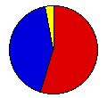
| Maps | 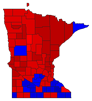 |  | | Pop. (m) | | Dem. (m) | | Ind. (m) | | Swg (m) | | Tnd (m) |
| |
| Demographic Data
| 1980 Population: | 4,075,970 | Enum. | 1980 Population Density: | 19.8 | persons/km2 | | 1976 Population: | 3,956,602 | Est. | 1976 Population Density: | 19.2 | persons/km2 | | 1970 Population: | 3,806,103 | Enum. | 1970 Population Density: | 18.5 | persons/km2 | | Total Electoral Vote: | 10 | | Electoral Vote Density: | 395,660 | persons/EV | | Land Area (2000): | 206,189 | km2 | Annual Pop Growth Rate: | 0.7 | % |
| Election Data and Statistics:
| Election Tools
- Atlas Forum Image Code for Maps: County, Pop, Tnd, Swg
Data Sources:
- Source for Popular Vote data: Minnesota Secretary of State, "Vote for United States President, United States Senator, and Supreme Court by County," The Minnesota Legislative Manual 1977-1978 (St. Paul, 1977)
- Source for Population data: U.S. Census Bureau.
| Results for and Individual County:
|
|
| |


