| |
Presidential
Candidate | Vice Presidential
Candidate | Political
Party | Popular Vote | Electoral Vote |
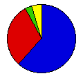
 | Richard Nixon | Spiro Agnew | Republican |
402,812 |
61.64% | 6 |
 | George McGovern | R. Sargent Shriver | Democrat |
198,540 |
30.38% | 0 |
 | Linda Jenness | Andrew Pulley | Soc. Workers |
30,945 |
4.74% | 0 |
| John Schmitz | Thomas Anderson | American Ind. |
21,208 |
3.25% | 0 |
 |
Map Key
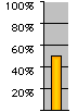
| Turnout
 |  |  |
|
| Maps | 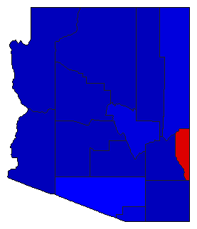 |  | | Pop. (m) | | Rep. (m) | | Dem. (m) | | Swg (m) | | Tnd (m) |
| |
| Election Notes:
- Ballot irregularities caused thousands of voters in two counties to cast ballots for both the Socialist Workers and major party candidates.
| Demographic Data
| 1980 Population: | 2,716,546 | Enum. | 1980 Population Density: | 9.2 | persons/km2 | | 1972 Population: | 2,008,847 | Est. | 1972 Population Density: | 6.8 | persons/km2 | | 1970 Population: | 1,775,399 | Enum. | 1970 Population Density: | 6.0 | persons/km2 | | Total Electoral Vote: | 6 | | Electoral Vote Density: | 334,808 | persons/EV | | Land Area (2000): | 294,312 | km2 | Annual Pop Growth Rate: | 4.3 | % |
| Presidential Electors:
- Method of Choosing:Popular Vote - Winner-Take-All
- Table of Presidential Electors for Arizona in 1972 (m)
| Election Data and Statistics:
| Election Tools
- Atlas Forum Image Code for Maps: County, Pop, Tnd, Swg
Data Sources:
- Source for Popular Vote data: Arizona Secretary of State, State of Arizona Official Canvass General Election - November 7, 1972 (Phoenix, 0)
- Source for Population data: U.S. Census Bureau.
| Results for and Individual County:
|
|
| |


