| |
Presidential
Candidate | Vice Presidential
Candidate | Political
Party | Popular Vote | Electoral Vote |
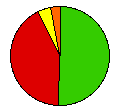
 | Theodore Roosevelt | Hiram Johnson | Republican |
58,811 |
50.56% | 5 |
 | Woodrow Wilson | Thomas Marshall | Democrat |
48,942 |
42.07% | 0 |
 | Eugene Debs | Emil Seidel | Socialist |
4,662 |
4.01% | 0 |
| Eugene Chafin | Aaron Watkins | Prohibition |
3,910 |
3.36% | 0 |
 |
Map Key
| Turnout
 |  |  |
|
| Maps | County Map (m) |  | | Rep. (m) | | Dem. (m) |
| |
| Demographic Data
| 1920 Population: | 636,547 | Enum. | 1920 Population Density: | 3.2 | persons/km2 | | 1910 Population: | 583,888 | Enum. | 1910 Population Density: | 3.0 | persons/km2 | | Total Electoral Vote: | 5 | | | Land Area (2000): | 196,540 | km2 | Annual Pop Growth Rate: | 0.9 | % |
| Election Data and Statistics:
- County Data (Table) (m)
- County Data (Graphs) (m)
|
| | Election Tools
- Atlas Forum Image Code for Maps: County
Data Sources:
- Source for Popular Vote data: South Dakota Secretary of State, comp., "Official Vote - November Election, 1912 Presidential Electors," South Dakota Legislative Manual 1913 (Pierre: State Publishing Co., 1913)
- Source for Population data: U.S. Census Bureau.
| Results for and Individual County:
|
|
| |


