| |
Presidential
Candidate | Vice Presidential
Candidate | Political
Party | Popular Vote | Electoral Vote |
 | Richard Nixon | Spiro Agnew | Republican |
505,125 |
78.20% | 7 |
 | George McGovern | R. Sargent Shriver | Democrat |
126,782 |
19.63% | 0 |
 | John Schmitz | Thomas Anderson | Independent |
11,598 |
1.80% | 0 |
| Linda Jenness | Andrew Pulley | Independent |
2,458 |
0.38% | 0 |
 |
Map Key
| > 50% |
 |
 |
| > 60% |
 |
 |
| > 70% |
|
 |
| > 80% |
|
 |
| > 90% |
|
 |
| Turnout
 |  |  |
|
| Maps | 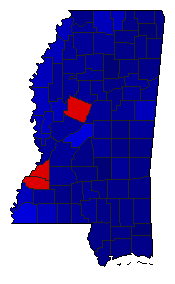 |  | | Pop. (m) | | Rep. (m) | | Dem. (m) | | Swg (m) | | Tnd (m) |
| |
| Demographic Data
| 1980 Population: | 2,520,770 | Enum. | 1980 Population Density: | 20.7 | persons/km2 | | 1972 Population: | 2,307,291 | Est. | 1972 Population Density: | 19.0 | persons/km2 | | 1970 Population: | 2,216,994 | Enum. | 1970 Population Density: | 18.2 | persons/km2 | | Total Electoral Vote: | 7 | | Electoral Vote Density: | 329,613 | persons/EV | | Land Area (2000): | 121,488 | km2 | Annual Pop Growth Rate: | 1.3 | % |
| Election Data and Statistics:
| Election Tools
- Atlas Forum Image Code for Maps: County, Pop, Tnd, Swg
Data Sources:
- Source for Popular Vote data: Mississippi Secretary of State, "General Election November 7, 1972," Mississippi Official and Statistical Register 1972-1976 (Jackson, 1973)
- Source for Population data: U.S. Census Bureau.
| Results for and Individual County:
|
|
| |


