Home
2024
Election Results
Election Info
Weblog
Forum
Wiki
Search
Email
Login
Site Info
Store
2010 Gubernatorial General Election Results
Note: The Google advertisement links below may advocate political positions that this site does not endorse.
Gubernatorial
Candidate
Lt. Gubernatorial
Candidate
Political
Party
Popular Vote
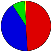
Deval Patrick
Tim Murray
Democratic
1,113,336
48.47%
Charlie Baker
Richard Tisei
Republican
964,951
42.01%
Tim Cahill
Paul Loscocco
Independent
184,387
8.03%
Jill Stein
Rick Purcell
Green-Rainbow
32,916
1.43%
Write-ins
-
-
1,547
0.07%
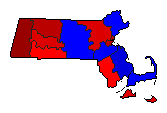
Map Key
> 40%
> 50%
> 60%
> 70%
Turnout
Maps
Election Notes:
Results include Corrected figures in the City of Cambridge, Middlesex County.
Demographic Data
2010 Population:
6,547,629
Enum.
2010 Population Density:
322.4
persons/km
2
2000 Population:
6,349,097
Enum.
2000 Population Density:
312.7
persons/km
2
Land Area (2000):
20,306
km
2
Annual Pop Growth Rate:
0.3
%
Election Data and Statistics:
County Data (Table)
(m)
County Data (Graphs)
City and Town Data
(m)
Voter Registration & Turnout Data
(m)
Purchase Detailed Data
Compare State Data by Year (Table)
Compare State Data by Year (Graphs)
View All 2010 Massachusetts Data
Compare State Maps by Year
View All 2010 Massachusetts Maps
Election Tools
Atlas Forum
Image Code for Maps:
County
,
Town
,
Pop
,
Tnd
,
Swg
Data Sources:
Source for Popular Vote data: Massachusetts Secretary of the Commonwealth. Elections Division.
Boston Globe
, Massachusetts Secretary of the Commonwealth. Elections Division ( ) (accessed 03 Nov 2010)
Source for Population data: U.S. Census Bureau.
Results for and Individual County:
Barnstable County
Berkshire County
Bristol County
Dukes County
Essex County
Franklin County
Hampden County
Hampshire County
Middlesex County
Nantucket County
Norfolk County
Plymouth County
Suffolk County
Worcester County
Primary Documentation:
2010 Official County Documents
The 2010 Campaign:
Pre-Election Polls
< 2006
Choose Year
2022
2018
2014
2006
2002
1998
1994
1990
1986
1982
1978
1974
1970
1966
1964
1962
1960
1958
1956
1954
1952
1950
1948
1946
1944
1942
1940
1938
1936
1934
1932
1930
1928
1926
1924
1922
1920
1919
1918
1917
1916
1915
1914
1913
1912
1911
1910
1909
1908
1907
1906
1905
1904
1903
1902
1901
1900
1899
1898
1897
1839
Choose Office
Secretary of State
State Treasurer
Attorney General
State Auditor
Choose State
Alabama
Alaska
Arizona
Arkansas
California
Colorado
Connecticut
Florida
Georgia
Hawaii
Idaho
Illinois
Iowa
Kansas
Maine
Maryland
Michigan
Minnesota
Nebraska
Nevada
New Hampshire
New Mexico
New York
Ohio
Oklahoma
Oregon
Pennsylvania
Rhode Island
South Carolina
South Dakota
Tennessee
Texas
Utah
Vermont
Wisconsin
Wyoming
2014 >
Massachusetts Election Results Home
-
National Results for 2010
-
Use Frame Navigation
Login
Terms of Use
-
DCMA Policy
-
Privacy Policy and Cookies
©
Dave Leip's Atlas of U.S. Elections, LLC 2019 All Rights Reserved


