| |
Presidential
Candidate | Vice Presidential
Candidate | Political
Party | Popular Vote | Electoral Vote |
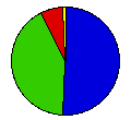
 | Calvin Coolidge | Charles Dawes | Republican |
420,759 |
51.18% | 12 |
 | Robert LaFollette | Burton Wheeler | Independent |
339,192 |
41.26% | 0 |
 | John Davis | Charles Bryan | Democrat |
55,913 |
6.80% | 0 |
 | William Foster | Benjamin Gitlow | Workers |
4,427 |
0.54% | 0 |
| Frank Johns | Verne Reynolds | Soc.-Indust. |
1,855 |
0.23% | 0 |
 |
Map Key
| Turnout
 |  |  |
|
| Maps | County Map (m) |  | | Rep. (m) | | Ind. (m) | | Dem. (m) | | Swg (m) | | Tnd (m) |
| |
| Demographic Data
| 1930 Population: | 2,563,953 | Enum. | 1930 Population Density: | 12.4 | persons/km2 | | 1920 Population: | 2,387,125 | Enum. | 1920 Population Density: | 11.6 | persons/km2 | | Total Electoral Vote: | 12 | | | Land Area (2000): | 206,189 | km2 | Annual Pop Growth Rate: | 0.7 | % |
| Election Data and Statistics:
- County Data (Table) (m)
- County Data (Graphs) (m)
|
| | Election Tools
- Atlas Forum Image Code for Maps: County, Tnd, Swg
Data Sources:
- Source for Popular Vote data: Minnesota Secretary of State, The Legislative Manual of the State of Minnesota 1925 (St. Paul, 1925)
- Source for Population data: U.S. Census Bureau.
| Results for and Individual County:
|
|
| |


