Home
2024
Election Results
Election Info
Weblog
Forum
Wiki
Search
Email
Login
Site Info
Store
2004 Initiative General Election Results - Montana
Note: The Google advertisement links below may advocate political positions that this site does not endorse.
Data for this Contest was Contributed by on 2007-06-01
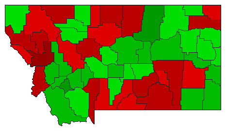
Initiative: I-147 (Cyanide Processing in Open-Pit Mines)
Popular Vote
No
257,280
58.04%
Yes
185,974
41.96%
Map Key
> 40%
> 50%
> 60%
> 70%
Turnout
Maps
Election Notes:
Initiative lifts ban on cyanide-leach processing in open-pit gold and silver mines.
Demographic Data
2010 Population:
989,415
Enum.
2010 Population Density:
2.6
persons/km
2
2004 Population:
930,009
Est.
2004 Population Density:
2.5
persons/km
2
2000 Population:
902,195
Enum.
2000 Population Density:
2.4
persons/km
2
Land Area (2000):
376,979
km
2
Annual Pop Growth Rate:
0.9
%
Election Data and Statistics:
County Data (Table)
(m)
County Data (Graphs)
Purchase Detailed Data
Compare State Data by Year (Table)
Compare State Data by Year (Graphs)
View All 2004 Montana Data
Compare State Maps by Year
View All 2004 Montana Maps
Election Tools
Atlas Forum
Image Code for Maps:
County
,
Pop
Data Sources:
Source for Popular Vote data: Montana Secretary of State.
2004 Statewide General Election Results- November 2nd, 2004
, Montana Secretary of State (http://sos.state.mt.us/ELB/archives/2004/2004-GenState.pdf) (accessed 1 Jun 2007)
Source for Population data: U.S. Census Bureau.
Results for and Individual County:
Beaverhead County
Big Horn County
Blaine County
Broadwater County
Carbon County
Carter County
Cascade County
Chouteau County
Custer County
Daniels County
Dawson County
Deer Lodge County
Fallon County
Fergus County
Flathead County
Gallatin County
Garfield County
Glacier County
Golden Valley County
Granite County
Hill County
Jefferson County
Judith Basin County
Lake County
Lewis and Clark County
Liberty County
Lincoln County
McCone County
Madison County
Meagher County
Mineral County
Missoula County
Musselshell County
Park County
Petroleum County
Phillips County
Pondera County
Powder River County
Powell County
Prairie County
Ravalli County
Richland County
Roosevelt County
Rosebud County
Sanders County
Sheridan County
Silver Bow County
Stillwater County
Sweet Grass County
Teton County
Toole County
Treasure County
Valley County
Wheatland County
Wibaux County
Yellowstone County
Choose Year
2016
2016
2016
2016
2012
2000
1998
1996
1996
1996
1996
1996
1992
1992
1992
1992
1992
1928
Choose Office
President
Governor
Secretary of State
Attorney General
State Auditor
CI-96
I-148
Choose State
Arizona
California
California
California
California
California
California
California
California
California
California
Colorado
Colorado
Nevada
Ohio
Oklahoma
Oregon
Oregon
Oregon
South Carolina
South Carolina
South Dakota
Utah
Washington
Washington
Washington
Washington
Montana Election Results Home
-
National Results for 2004
-
Use Frame Navigation
Login
Terms of Use
-
DCMA Policy
-
Privacy Policy and Cookies
©
Dave Leip's Atlas of U.S. Elections, LLC 2019 All Rights Reserved


