1910 Gubernatorial General Election Results - North Dakota
Note: The Google advertisement links below may advocate political positions that this site does not endorse.
Data for this Contest was Contributed by on 2010-03-31

  Gubernatorial
Candidate
Political
Party
Popular Vote
John BurkeDemocratic 47,005 49.96%
C. A. JohnsonRepublican 44,555 47.36%
I. S. LampmanSocialist 2,524 2.68%
State Seal Map Key
 > 40%
 > 50%
 > 60%
 > 70%
Turnout
Voter Turnout Graph
Vote Pie Chart
Maps
  1910 North Dakota County Map of General Election Results for Governor  
County Button
Per Vote Democratic Button
Per Vote Republican Button
 
Demographic Data

1910 Population:577,056Enum.1910 Population Density:3.2persons/km2
1900 Population:319,146Enum.1900 Population Density:1.8persons/km2
Land Area (2000):178,647km2Annual Pop Growth Rate:6.1%

Election Data and Statistics:
  • County Data (Table) (m)
  • County Data (Graphs) (m)
Election Tools
Data Sources:
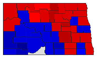
  • Source for Popular Vote data: North Dakota Secretary of State. State of North Dakota, 1913 Legislative Manual, North Dakota Secretary of State (http://books.google.com/books?id=8PVPOsL8Uv0C&printsec=frontcover&source=gbs_v2_summary_r&cad=0#v=onepage&q=&f=false) (accessed 31 Mar 2010)
  • Source for Population data: U.S. Census Bureau.
Results for and Individual County:
  • (m)


Adams County Barnes County Benson County Billings County Bottineau County Bowman County Burke County Burleigh County Cass County Cavalier County Dickey County Dunn County Eddy County Emmons County Foster County Grand Forks County Griggs County Hettinger County Kidder County LaMoure County Logan County McHenry County McIntosh County McKenzie County McLean County Mercer County Morton County Mountrail County Nelson County Oliver County Pembina County Pierce County Ramsey County Ransom County Renville County Richland County Rolette County Sargent County Sheridan County Stark County Steele County Stutsman County Towner County Traill County Walsh County Ward County Wells County Williams County