| |
Presidential
Candidate | Vice Presidential
Candidate | Political
Party | Popular Vote | Electoral Vote |
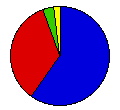
 | Theodore Roosevelt | Charles Fairbanks | Republican |
600,095 |
59.75% | 23 |
 | Alton Parker | Henry Davis | Democrat |
344,674 |
34.32% | 0 |
 | Eugene Debs | Benjamin Hanford | Socialist |
36,260 |
3.61% | 0 |
 | Silas Swallow | George Carroll | Prohibition |
19,339 |
1.93% | 0 |
| Charles Corregan | William Cox | Socialist Labor |
2,633 |
0.26% | 0 |
| Thomas Watson | Thomas Tibbles | People's |
1,392 |
0.14% | 0 |
 |
Map Key
| > 40% |
 |
 |
| > 50% |
 |
 |
| > 60% |
 |
 |
| > 70% |
 |
 |
| > 80% |
|
 |
| Turnout
 |  |  |
|
| Maps | County Map (m) |  |
| |
| Demographic Data
| 1910 Population: | 4,767,121 | Enum. | 1910 Population Density: | 44.9 | persons/km2 | | 1900 Population: | 4,157,545 | Enum. | 1900 Population Density: | 39.2 | persons/km2 | | Total Electoral Vote: | 23 | | | Land Area (2000): | 106,056 | km2 | Annual Pop Growth Rate: | 1.4 | % |
| Election Data and Statistics:
- County Data (Table) (m)
- County Data (Graphs) (m)
|
| | Election Tools
- Atlas Forum Image Code for Maps: County
Data Sources:
- Source for Popular Vote data: Ohio Secretary of State, "Vote for Presidential Electors at the Election Held November 8, 1904," Annual Report of the Secretary of State to the Governor of the State of Ohio for the Year Ending November 15, 1904 (Springfield: The Springfield Publishing Company, 1905)
- Source for Population data: U.S. Census Bureau.
| Results for and Individual County:
|
|
| |


