1982 State Treasurer General Election Results - Arizona
Note: The Google advertisement links below may advocate political positions that this site does not endorse.
Data for this Contest was Contributed by on 2011-01-25

  State Treasurer
Candidate
Political
Party
Popular Vote
Ray RottasRepublican 335,044 51.05%
Mike MorganDemocratic 321,239 48.95%
State Seal Map Key
 > 50%
 > 60%
 > 70%
 > 80%
Turnout
Voter Turnout Graph
Vote Pie Chart
Maps
  1982 Arizona County Map of General Election Results for State Treasurer  
County Button
Pop. (m)
Per Vote Republican Button
Per Vote Democratic Button
 
Demographic Data

1990 Population:3,665,339Enum.1990 Population Density:12.5persons/km2
1982 Population:0Est.1982 Population Density:0.0persons/km2
1980 Population:2,716,546Enum.1980 Population Density:9.2persons/km2
Land Area (2000):294,312km2Annual Pop Growth Rate:3.0%

Election Data and Statistics:
Election Tools
Data Sources:
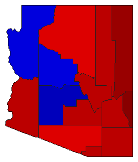
  • Source for Popular Vote data: Arizona Secretary of State. Elections. State of Arizona Official Canvass - General Election - November 2, 1982, Arizona Secretary of State. Elections (http://www.azsos.gov/election/1982/General/Canvass1982GE.pdf) (accessed 25 Jan 2011)
  • Source for Population data: U.S. Census Bureau.
Results for and Individual County:
  • (m)


Apache County Cochise County Coconino County Gila County Graham County Greenlee County Greenlee County Maricopa County Mohave County Navajo County Pima County Pinal County Santa Cruz County Yavapai County Yuma County