| |
Presidential
Candidate | Vice Presidential
Candidate | Political
Party | Popular Vote | Electoral Vote |
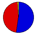
 | William McKinley | Theodore Roosevelt | Republican |
185,955 |
52.56% | 10 |
 | William Bryan | Adlai Stevenson | Democrat |
162,601 |
45.96% | 0 |
 | John Woolley | Henry Metcalf | Prohibition |
3,605 |
1.02% | 0 |
| Eugene Debs | Job Harriman | Social Democrat |
1,605 |
0.45% | 0 |
 |
Map Key
| Turnout
 |  |  |
|
| Maps | County Map (m) |  |
| |
| Election Notes:
- Bryan data is the fusion of Democratic and People's parties (same set of electors on two tickets)
| Demographic Data
| 1900 Population: | 1,470,495 | Enum. | 1900 Population Density: | 6.9 | persons/km2 | | 1890 Population: | 0 | Enum. | 1890 Population Density: | 0.0 | persons/km2 | | Total Electoral Vote: | 10 | | Electoral Vote Density: | 147,050 | persons/EV | | Land Area (2000): | 211,900 | km2 | Annual Pop Growth Rate: | 0 | % |
| Election Data and Statistics:
- County Data (Table) (m)
- County Data (Graphs) (m)
|
| | Election Tools
- Atlas Forum Image Code for Maps: County
Data Sources:
- Source for Popular Vote data: Kansas Secretary of State, "Statement of Official Vote State of Kansas, 1900," Twelfth Biennial Report of the Secretary of State of the State of Kansas (Topeka, 1901)
- Source for Population data: U.S. Census Bureau.
| Results for and Individual County:
|
|
| |


