Home
2024
Election Results
Election Info
Weblog
Forum
Wiki
Search
Email
Login
Site Info
Store
2012 Gubernatorial General Election Results
Note: The Google advertisement links below may advocate political positions that this site does not endorse.
Gubernatorial
Candidate
Lt. Gubernatorial
Candidate
Political
Party
Popular Vote
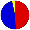
Steve Bullock
John Walsh
Democratic
236,450
48.90%
Rick Hill
Jon Sonju
Republican
228,879
47.34%
Ron Vandevender
Marc Mulcahy
Libertarian
18,160
3.76%
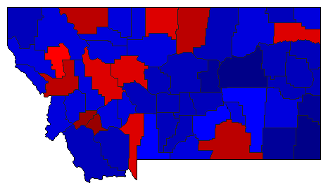
Map Key
> 40%
> 50%
> 60%
> 70%
> 80%
Turnout
Maps
Demographic Data
2012 Population:
1,004,168
Est.
2012 Population Density:
2.7
persons/km
2
2010 Population:
989,415
Enum.
2010 Population Density:
2.6
persons/km
2
Land Area (2000):
376,979
km
2
Annual Pop Growth Rate:
0.7
%
Election Data and Statistics:
County Data (Table)
(m)
County Data (Graphs)
Purchase Detailed Data
Compare State Data by Year (Table)
Compare State Data by Year (Graphs)
View All 2012 Montana Data
Compare State Maps by Year
View All 2012 Montana Maps
Election Tools
Atlas Forum
Image Code for Maps:
County
,
Pop
,
Tnd
,
Swg
Data Sources:
Source for Popular Vote data: Montana Secretary of State.
2012 Statewide General Election Canvass
, Montana Secretary of State (http://sos.mt.gov/elections/2012/2012_General_Canvass.pdf ) (accessed 29 Nov 2012)
Source for Population data: U.S. Census Bureau.
Results for and Individual County:
Beaverhead County
Big Horn County
Blaine County
Broadwater County
Carbon County
Carter County
Cascade County
Chouteau County
Custer County
Daniels County
Dawson County
Deer Lodge County
Fallon County
Fergus County
Flathead County
Gallatin County
Garfield County
Glacier County
Golden Valley County
Granite County
Hill County
Jefferson County
Judith Basin County
Lake County
Lewis and Clark County
Liberty County
Lincoln County
McCone County
Madison County
Meagher County
Mineral County
Missoula County
Musselshell County
Park County
Petroleum County
Phillips County
Pondera County
Powder River County
Powell County
Prairie County
Ravalli County
Richland County
Roosevelt County
Rosebud County
Sanders County
Sheridan County
Silver Bow County
Stillwater County
Sweet Grass County
Teton County
Toole County
Treasure County
Valley County
Wheatland County
Wibaux County
Yellowstone County
Primary Documentation:
2012 Official County Documents
The 2012 Campaign:
Pre-Election Polls
< 2008
Choose Year
2020
2016
2008
2004
2000
1996
1992
1988
1984
1980
1976
1972
1968
1964
1960
1956
1952
1948
1944
1940
1936
1932
1928
1924
1920
1916
1912
Choose Office
President
Senator
US Representative
Secretary of State
Attorney General
State Auditor
LR-120
LR-121
LR-122
IR-124
I-166
Choose State
Delaware
Indiana
Missouri
New Hampshire
North Carolina
North Dakota
Utah
Vermont
Washington
West Virginia
Wisconsin
2016 >
Montana Election Results Home
-
National Results for 2012
-
Use Frame Navigation
Login
Terms of Use
-
DCMA Policy
-
Privacy Policy and Cookies
©
Dave Leip's Atlas of U.S. Elections, LLC 2019 All Rights Reserved


