


 The Atlas is partnering with UUorld (pronounced “World”) GIS software developer to provide election data in formats capable of being imported to the UUorld application. A link has been added to your myatlas page to the UUorld Export Script. All data sets purchased from the Atlas are available to you for export.
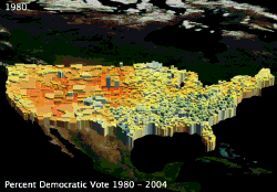
The application’s primary feature is the ability to extrude shapes in a three dimensional projection providing a geographic visual representation of relative data. 2-D mapping options are also available. One particular feature is the ability to produce animated time-series movies such the percent vote for Democratic Party Presidential candidates for the general elections between 1980 and 2004 (shown in this post). See some more examples of the Atlas data here. More data export options will be developed in the coming months. User feedback welcome.
*Update* UUorld is offering a $50 Rebate on the commercial version of UUorld with a receipt for an Atlas data purchase.
 The
The