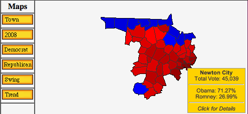
The Atlas is in the process of upgrading the county township maps in the members section. Going beyond the previous flat vote result map, the new maps are enhanced and greatly expanded, including an image-map to highlight the name of the city/town and the summary result in a pop-up window, include mouse-over maps/links for party, swing, trend, and the previous vote result. In addition, the maps are also larger. Currently, these new maps and features are available for President in 2012 and 2008 in New Hampshire, Vermont, Massachusetts, Connecticut, New York, Rhode Island, as well as brand new maps for New Jersey. I’m currently in the process of creating the Maine maps – an endeavor that is taking quite some effort due to the large mismatch between the available census maps and the township entities that are included in the Maine official results. Future expansion of this feature is planned to include more states, more offices, and more elections further back in time.