


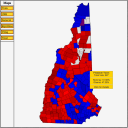
 The Atlas has incorporated a new map set – statewide city and town maps (county subdivision) for New England states (plus NY and NJ for some Presidential Elections). Currently, maps are available for President 1992-2012 and Governor in some contests from 1990-2012, with more on the way. These statewide maps include mouse-over map buttons for party, swing, trend, and last election result (same function as available on the county map pages). In addition, these statewide maps include image-maps with a pop-up box that shows the city or town name plus the high-level election result. Clicking on a city or town opens the results page for that county subdivision. The 2012 maps are available to members and non-members alike, but due to the high-data content of these pages, older election maps are currently limited to the members section.
Login