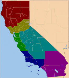
The Six Californias Initiative is in the news for having submitted signatures for a ballot measure to split the state of California into six smaller states. How would such a dramatic change have impacted the 2012 General Election for President?
The proposed states are defined as follows: Jefferson (red), consisting of 14 counties in the north of the state to the Oregon Border, North California (gold) consisting of 13 counties running north of San Francisco to Lake Tahoe, Silicon Valley (green) consisting of eight counties from Contra Costa to Monterey, Central California (cyan) consisting of 14 counties north of Los Angeles and south of Sacramento, West California consisting of the four counties of Los Angeles, Ventura, San Luis Obispo, and Santa Barbara, and South California (magenta) consisting of the five counties in the southern part of the state south and east of Los Angeles.
To determine the number of Presidential Electors for the six new states, the representatives apportioned to each state is calculated using the Method of Equal Proportions based on the population figures from the 2010 U.S. Census. Jefferson would become the seventh smallest state with more population than Delaware but less than Montana any have only one representative. North California would have five, Silicon Valley nine, Central California six, West California 16, and South California 15. The combined number of representatives of the six Californias is 52, one fewer than the whole of California today. The one representative lost by the “Californias” is picked up by North Carolina. However, the six Californias would pick up 10 new U. S. Senators, for a total of 64 electoral votes in all (nine more than the current 55 electoral votes). The table below shows the breakdown of the total representatives and electoral votes for the proposed states, assuming that the size of the House of Representatives remains at 435.
| Proposed State | Population (2010) | Rep | Sen | EV |
|---|---|---|---|---|
| Jefferson | 949,240 | 1 | 2 | 3 |
| North California | 3,742,229 | 5 | 2 | 7 |
| Silicon Valley | 6,597,332 | 9 | 2 | 11 |
| Central California | 4,124,776 | 6 | 2 | 8 |
| West California | 11,335,455 | 16 | 2 | 18 |
| South California | 10,504,924 | 15 | 2 | 17 |
The Presidential Election results for these six states are quite interesting. Three of the states – Jefferson, Central California, and South California – are competitive with a margin of victory less than 3.5%. Romney wins Jefferson and Central California, while Obama wins the remaining four. The table below shows the data.
| Proposed State | Total Vote | Margin | % | %O | %R | Vote Obama | Vote Romney |
|---|---|---|---|---|---|---|---|
| Jefferson | 381,322 | 12,347 | 3.2% | 46.0% | 49.3% | 175,551 | 187,898 |
| N. California | 1,536,378 | 289,964 | 18.9% | 57.9% | 39.0% | 889,742 | 599,778 |
| Silicon Valley | 2,590,814 | 1,295,981 | 50.0% | 73.5% | 23.5% | 1,904,135 | 608,154 |
| C. California | 1,147,447 | 31,011 | 2.7% | 47.3% | 50.0% | 542,933 | 573,994 |
| W. California | 3,798,630 | 1,385,355 | 36.5% | 67.0% | 30.5% | 2,543,219 | 1,157,864 |
| S. California | 3,601,224 | 86,385 | 2.4% | 50.0% | 47.6% | 1,798,705 | 1,712,320 |
The electoral vote breakdown from the six Californias is 11 for Romney and 53 for Obama, with an additional one vote for Romney picked up in North Carolina due to the apportionment of one more representative to North Carolina as mentioned above. The overall electoral vote total is: Obama 330 to Romney 218. The national electoral vote map for this scenario is shown below:
Forum discussion topic is located here.


