| |
Presidential
Candidate | Vice Presidential
Candidate | Political
Party | Popular Vote | Electoral Vote |
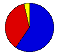
 | Gerald Ford | Robert Dole | Republican |
204,151 |
59.88% | 4 |
 | James Carter | Walter Mondale | Democrat |
126,549 |
37.12% | 0 |
 | Lester Maddox | William Dyke | American Ind. |
5,935 |
1.74% | 0 |
| Roger MacBride | David Bergland | Libertarian |
3,558 |
1.04% | 0 |
| Lyndon LaRouche | R. Wayne Evans | U.S. Labor |
739 |
0.22% | 0 |
 |
Map Key
| Turnout
 |  |  |
|
| Maps | 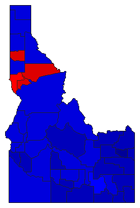 |  | | Pop. (m) | | Rep. (m) | | Dem. (m) | | Swg (m) | | Tnd (m) |
| |
| Demographic Data
| 1980 Population: | 944,127 | Enum. | 1980 Population Density: | 4.4 | persons/km2 | | 1976 Population: | 856,979 | Est. | 1976 Population Density: | 4.0 | persons/km2 | | 1970 Population: | 713,015 | Enum. | 1970 Population Density: | 3.3 | persons/km2 | | Total Electoral Vote: | 4 | | Electoral Vote Density: | 214,245 | persons/EV | | Land Area (2000): | 214,314 | km2 | Annual Pop Growth Rate: | 2.8 | % |
| Election Data and Statistics:
| Election Tools
- Atlas Forum Image Code for Maps: County, Pop, Tnd, Swg
Data Sources:
- Source for Popular Vote data: Idaho Secretary of State, "Abstract of Votes Cast at the General Election November 2, 1976 State of Idaho," Idaho Blue Book 1977-1978 (Boise, 1977)
- Source for Population data: U.S. Census Bureau.
| Results for and Individual County:
|
|
| |


