| |
Presidential
Candidate | Vice Presidential
Candidate | Political
Party | Popular Vote | Electoral Vote |
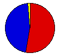
 | James Carter | Walter Mondale | Democrat |
615,717 |
52.75% | 9 |
 | Gerald Ford | Robert Dole | Republican |
531,852 |
45.57% | 0 |
 | Thomas Anderson | Rufus Shackelford | American |
8,308 |
0.71% | 0 |
| Eugene McCarthy | - | Independent |
6,837 |
0.59% | 0 |
| Lester Maddox | William Dyke | American Ind. |
2,328 |
0.20% | 0 |
| Roger MacBride | David Bergland | Libertarian |
814 |
0.07% | 0 |
| Lyndon LaRouche | R. Wayne Evans | U.S. Labor |
510 |
0.04% | 0 |
| Gus Hall | Jarvis Tyner | Communist |
426 |
0.04% | 0 |
| Peter Camejo | Willie Mae Reid | Soc. Workers |
350 |
0.03% | 0 |
 |
Map Key
| > 40% |
 |
 |
| > 50% |
 |
 |
| > 60% |
 |
 |
| > 70% |
 |
 |
| > 80% |
 |
 |
| Turnout
 |  |  |
|
| Maps | 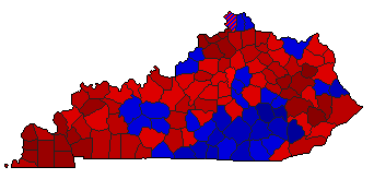 |  | | Pop. (m) | | Dem. (m) | | Rep. (m) | | Swg (m) | | Tnd (m) |
| |
| Demographic Data
| 1980 Population: | 3,660,324 | Enum. | 1980 Population Density: | 35.6 | persons/km2 | | 1976 Population: | 3,530,443 | Est. | 1976 Population Density: | 34.3 | persons/km2 | | 1970 Population: | 3,220,711 | Enum. | 1970 Population Density: | 31.3 | persons/km2 | | Total Electoral Vote: | 9 | | Electoral Vote Density: | 392,271 | persons/EV | | Land Area (2000): | 102,896 | km2 | Annual Pop Growth Rate: | 1.3 | % |
| Election Data and Statistics:
| Election Tools
- Atlas Forum Image Code for Maps: County, Pop, Tnd, Swg
Data Sources:
- Source for Popular Vote data: Kentucky State Board of Elections. General Election Nov 2, 1976, Kentucky State Board of Elections (
) (accessed )
- Source for Population data: U.S. Census Bureau.
| Results for and Individual County:
|
|
| |


