| |
Presidential
Candidate | Vice Presidential
Candidate | Political
Party | Popular Vote | Electoral Vote |
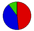
 | Hubert Humphrey | Edmund Muskie | Democrat |
1,593,082 |
48.18% | 21 |
 | Richard Nixon | Spiro Agnew | Republican |
1,370,665 |
41.46% | 0 |
 | George Wallace | S. Marvin Griffin | American Ind. |
331,968 |
10.04% | 0 |
 | Other (+) | - | - |
10,535 |
0.32% | 0 |
 |
Map Key
| Turnout
 |  |  |
|
| Maps |  |  | | Dem. (m) | | Rep. (m) | | Ame. (m) | | Swg (m) | | Tnd (m) |
| |
| Demographic Data
| 1970 Population: | 8,881,826 | Enum. | 1970 Population Density: | 60.4 | persons/km2 | | 1960 Population: | 7,823,194 | Enum. | 1960 Population Density: | 53.2 | persons/km2 | | Total Electoral Vote: | 21 | | | Land Area (2000): | 147,121 | km2 | Annual Pop Growth Rate: | 1.3 | % |
| Election Data and Statistics:
| Election Tools
- Atlas Forum Image Code for Maps: County, Tnd, Swg
Data Sources:
- Source for Popular Vote data: Michigan Department of Administration, "Official Canvass of Votes, General Election November 5, 1968 President and Vice President of the United States," Michigan Manual 1969-1970 (Lansing, 1969)
- Source for Population data: U.S. Census Bureau.
| Results for and Individual County:
|
|
| |


