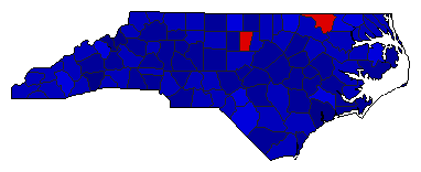
|
Presidential Candidate | Vice Presidential Candidate | Political Party | Popular Vote | Electoral Vote |
![](IMAGES/COLOR/0000DD.gif) | Richard Nixon | Spiro Agnew | Republican |
1,054,889 |
69.46% | 13 |
![](IMAGES/COLOR/DD0000.gif) | George McGovern | R. Sargent Shriver | Democrat |
438,705 |
28.89% | 0 |
![](IMAGES/COLOR/FFFF00.gif) | John Schmitz | Thomas Anderson | American |
25,018 |
1.65% | 0 |
![Seal](IMAGES/seal.png) |
Map Key
| Turnout
![Voter Turnout Graph](IMAGES/VTO/pevto43.png) | ![Vote Pie Chart](img.php?type=pie&year=1972&st=NC&off=0&elect=0) | ![State Seal](IMAGES/SEAL/sealNC.png) |
|
Maps | ![1972 North Carolina County Map of General Election Results for President](img.php?type=map&year=1972&fips=37&st=NC&off=0&elect=0) | ![County Button](IMAGES/B_NAT/PEBuCountyMap.gif) | Pop. (m) | Rep. (m) | Dem. (m) | Swg (m) | Tnd (m) |
|
| Demographic Data
1980 Population: | 5,880,095 | Enum. | 1980 Population Density: | 46.6 | persons/km2 | 1972 Population: | 5,296,085 | Est. | 1972 Population Density: | 42.0 | persons/km2 | 1970 Population: | 5,084,411 | Enum. | 1970 Population Density: | 40.3 | persons/km2 | Total Electoral Vote: | 13 | | Electoral Vote Density: | 407,391 | persons/EV | Land Area (2000): | 126,161 | km2 | Annual Pop Growth Rate: | 1.5 | % |
| Election Data and Statistics:
| Election Tools
- Atlas Forum Image Code for Maps: County, Pop, Tnd, Swg
Data Sources:
- Source for Popular Vote data: North Carolina Secretary of State, "Vote for President by Counties 1972," North Carolina Manual 1973 (Raleigh, 0)
- Source for Population data: U.S. Census Bureau.
| Results for and Individual County:
|
|
| |