| |
Presidential
Candidate | Vice Presidential
Candidate | Political
Party | Popular Vote | Electoral Vote |
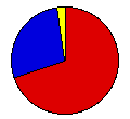
 | Franklin Roosevelt | John Garner | Democratic |
178,350 |
69.59% | 4 |
 | Herbert Hoover | Charles Curtis | Republican |
71,772 |
28.00% | 0 |
 | Norman Thomas | James Maurer | Socialist |
3,521 |
1.37% | 0 |
| William Harvey | Frank Hemenway | Liberty |
1,817 |
0.71% | 0 |
| William Foster | James Ford | Communist |
830 |
0.32% | 0 |
 |
Map Key
| Turnout
 |  |  |
|
| Maps | County Map (m) |  | | Dem. (m) | | Rep. (m) | | Swg (m) | | Tnd (m) |
| |
| Demographic Data
| 1940 Population: | 641,935 | Enum. | 1940 Population Density: | 3.6 | persons/km2 | | 1930 Population: | 680,845 | Enum. | 1930 Population Density: | 3.8 | persons/km2 | | Total Electoral Vote: | 4 | | | Land Area (2000): | 178,647 | km2 | Annual Pop Growth Rate: | -0.6 | % |
| Election Data and Statistics:
- County Data (Table) (m)
- County Data (Graphs) (m)
|
| | Election Tools
- Atlas Forum Image Code for Maps: County, Tnd, Swg
Data Sources:
- Source for Popular Vote data: North Dakota Secretary of State, comp., "Official Abstract of Votes Cast at the General Election Held November 8th, 1932," Compilation of Election Returns National and State 1930 - 1944 (Bismarck, 1945)
- Source for Population data: U.S. Census Bureau.
| Results for and Individual County:
|
|
| |


