| |
Presidential
Candidate | Vice Presidential
Candidate | Political
Party | Popular Vote | Electoral Vote |
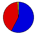
 | Herbert Hoover | Charles Curtis | Republican |
78,984 |
57.66% | 3 |
 | Franklin Roosevelt | John Garner | Democratic |
56,266 |
41.08% | 0 |
 | Norman Thomas | James Maurer | Socialist |
1,533 |
1.12% | 0 |
| William Foster | James Ford | Communist |
195 |
0.14% | 0 |
| Write-ins | - | - |
2 |
0.00% | 0 |
 |
Map Key
| Turnout
 |  |  |
|
| Maps | County Map (m) |  | | Rep. (m) | | Dem. (m) | | Swg (m) | | Tnd (m) |
| |
| Demographic Data
| 1940 Population: | 359,231 | Enum. | 1940 Population Density: | 15.0 | persons/km2 | | 1930 Population: | 359,611 | Enum. | 1930 Population Density: | 15.0 | persons/km2 | | Total Electoral Vote: | 3 | | | Land Area (2000): | 23,956 | km2 | Annual Pop Growth Rate: | -0.0 | % |
| Election Data and Statistics:
- County Data (Table) (m)
- County Data (Graphs) (m)
|
| | Election Tools
- Atlas Forum Image Code for Maps: County, Tnd, Swg
Data Sources:
- Source for Popular Vote data: Vermont Secretary of State, "Presidential Election," Vermont Legislative Directory Biennial Session 1933 (Montpelier, 1933)
- Source for Population data: U.S. Census Bureau.
| Results for and Individual County:
|
|
| |


