| |
Presidential
Candidate | Vice Presidential
Candidate | Political
Party | Popular Vote | Electoral Vote |
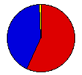
 | William Bryan | Arthur Sewall | Democrat |
53,314 |
56.97% | 4 |
 | William McKinley | Garret Hobart | Republican |
39,153 |
41.84% | 0 |
 | Joshua Levering | Hale Johnson | Prohibition |
968 |
1.03% | 0 |
| Charles Bentley | James Southgate | National Party |
148 |
0.16% | 0 |
 |
Map Key
| > 40% |
 |
 |
| > 50% |
 |
 |
| > 60% |
 |
 |
| > 70% |
 |
 |
| > 80% |
 |
|
| Turnout
 |  |  |
|
| Maps | County Map (m) |  |
| |
| Election Notes:
- Two Presidential Electors cast their Vice Presidential ballots for Thomas Watson.
| Demographic Data
| 1900 Population: | 518,103 | Enum. | 1900 Population Density: | 3.0 | persons/km2 | | 1890 Population: | 0 | Enum. | 1890 Population Density: | 0.0 | persons/km2 | | Total Electoral Vote: | 4 | | | Land Area (2000): | 172,348 | km2 | Annual Pop Growth Rate: | 0 | % |
| Election Data and Statistics:
- County Data (Table) (m)
- County Data (Graphs) (m)
|
| | Election Tools
- Atlas Forum Image Code for Maps: County
Data Sources:
- Source for Popular Vote data: Washington Secretary of State, "Electors of President and Vice President," Abstract of Votes Polled in the State of Washington, at the General Election Held November 3, 1896 (Olympia, 1896)
- Source for Population data: U.S. Census Bureau.
| Results for and Individual County:
|
|
| |


