1928 Initiative General Election Results - Montana
Note: The Google advertisement links below may advocate political positions that this site does not endorse.
Data for this Contest was Contributed by on 2015-12-02

  Initiative: I-32 (Adopt the Federal Prohibition Laws)Popular Vote
No 80,619 54.09%
Yes 68,431 45.91%
State Seal Map Key
 > 40%
 > 50%
 > 60%
 > 70%
Turnout
Voter Turnout Graph
Vote Pie Chart
Maps
  1928 Montana County Map of General Election Results for Initiative  
County Button
Per Vote  Button
Per Vote  Button
 
Election Notes:
  • The proposed initiative would enact and enforce all of the provisions of the federal prohibition laws as defined by the Volstead Act.
Demographic Data

1930 Population:537,606Enum.1930 Population Density:1.4persons/km2
1920 Population:548,889Enum.1920 Population Density:1.5persons/km2
Land Area (2000):376,979km2Annual Pop Growth Rate:-0.2%

Election Data and Statistics:
  • County Data (Table) (m)
  • County Data (Graphs) (m)
Election Tools
Data Sources:
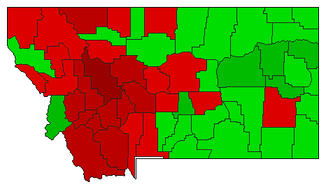
  • Source for Popular Vote data: Montana Secretary of State. Official Abstract of Votes Cast at the General Election in Montana. Nov. 6, 1928., Montana Secretary of State (https://archive.org/stream/officialmontanag1928montrich#page/n1/mode/2up) (accessed 30 Nov 2015)
  • Source for Population data: U.S. Census Bureau.
Results for and Individual County:
  • (m)


Beaverhead County Big Horn County Blaine County Broadwater County Carbon County Carter County Cascade County Chouteau County Custer County Daniels County Dawson County Deer Lodge County Fallon County Fergus County Flathead County Gallatin County Garfield County Glacier County Golden Valley County Granite County Hill County Jefferson County Judith Basin County Lake County Lewis and Clark County Liberty County Lincoln County McCone County Madison County Meagher County Mineral County Missoula County Musselshell County Park County Petroleum County Phillips County Pondera County Powder River County Powell County Prairie County Ravalli County Richland County Roosevelt County Rosebud County Sanders County Sheridan County Silver Bow County Stillwater County Sweet Grass County Teton County Toole County Treasure County Valley County Wheatland County Wibaux County Yellowstone County