1936 Referendum General Election Results - Vermont
Note: The Google advertisement links below may advocate political positions that this site does not endorse.
Data for this Contest was Contributed by on 2018-02-22

  Referendum: Vote on Parkway ReferendumPopular Vote
No 42,318 57.80%
Yes 30,897 42.20%
State Seal Map Key
 > 50%
 > 60%
 > 70%
 > 80%
Turnout
Voter Turnout Graph
Vote Pie Chart
Maps
  1936 Vermont County Map of General Election Results for Referendum  
County Button
Per Vote  Button
Per Vote  Button
 
Election Notes:
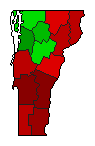
  • "Shall an act of the special session of 1935, entitled, 'An Act for the establishment of a national park, known as the Green Mountain Parkway, limiting the lands held therefor, prescribing the jurisdiction to be retained by the state, making an appropriation in connection therewith and providing for a bond issue,' take effect on the first day of April, 1936?"
Demographic Data

1940 Population:359,231Enum.1940 Population Density:15.0persons/km2
1930 Population:359,611Enum.1930 Population Density:15.0persons/km2
Land Area (2000):23,956km2Annual Pop Growth Rate:-0.0%

Election Data and Statistics:
  • County Data (Table) (m)
  • County Data (Graphs) (m)
Election Tools
Data Sources:
  • Source for Popular Vote data: Vermont State Department, comp., "Vote on Green Mountain Parkway, March 3, 1936," Vermont Legislative Directory - 1937 (Brattleboro, VT: The Vermont Printing Company, 1937)
  • Source for Population data: U.S. Census Bureau.
Results for and Individual County:
  • (m)


Addison County Bennington County Caledonia County Chittenden County Essex County Franklin County Grand Isle County Lamoille County Orange County Orleans County Rutland County Washington County Windham County Windsor County