| |
Presidential
Candidate | Vice Presidential
Candidate | Political
Party | Popular Vote | Electoral Vote |
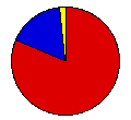
 | James Carter | Walter Mondale | Democrat |
137,818 |
81.63% | 3 |
 | Gerald Ford | Robert Dole | Republican |
27,873 |
16.51% | 0 |
 | Write-ins | - | - |
1,944 |
1.15% | 0 |
| Peter Camejo | Willie Mae Reid | Soc. Workers |
545 |
0.32% | 0 |
| Other (+) | - | - |
650 |
0.39% | 0 |
 |
Map Key
| Turnout
 |  |  |
|
| Maps |  |  | | Pop. (m) | | Dem. (m) | | Rep. (m) | | Swg (m) | | Tnd (m) |
| |
| Demographic Data
| 1980 Population: | 638,432 | Enum. | 1980 Population Density: | 4,015.3 | persons/km2 | | 1976 Population: | 696,305 | Est. | 1976 Population Density: | 4,379.3 | persons/km2 | | 1970 Population: | 756,668 | Enum. | 1970 Population Density: | 4,758.9 | persons/km2 | | Total Electoral Vote: | 3 | | Electoral Vote Density: | 232,102 | persons/EV | | Land Area (2000): | 159 | km2 | Annual Pop Growth Rate: | -1.7 | % |
| Election Data and Statistics:
| Election Tools
- Atlas Forum Image Code for Maps: County, Pop, Tnd, Swg
Data Sources:
- Source for Popular Vote data: Clerk of the House of Representatives, comp., Statistics of the Presidential and Congressional Election of November 2, 1976 (Washington: U.S. Government Printing Office, 1977)
- Source for Population data: U.S. Census Bureau.
| Results for and Individual County:
|
|
| |


