| |
Presidential
Candidate | Vice Presidential
Candidate | Political
Party | Popular Vote | Electoral Vote |
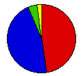
 | Grover Cleveland | Adlai Stevenson | Democrat |
262,740 |
47.46% | 15 |
 | Benjamin Harrison | Whitelaw Reid | Republican |
255,615 |
46.17% | 0 |
 | James Weaver | James Field | People's |
22,208 |
4.01% | 0 |
 | John Bidwell | James Cranfill | Prohibition |
13,050 |
2.36% | 0 |
 |
Map Key
| Turnout
 |  |  |
|
| Maps | County Map (m) |  |
| |
| Demographic Data
| 1900 Population: | 2,516,462 | Enum. | 1900 Population Density: | 27.1 | persons/km2 | | 1890 Population: | 0 | Enum. | 1890 Population Density: | 0.0 | persons/km2 | | Total Electoral Vote: | 15 | | | Land Area (2000): | 92,895 | km2 | Annual Pop Growth Rate: | 0 | % |
| Election Data and Statistics:
- County Data (Table) (m)
- County Data (Graphs) (m)
|
| | Election Tools
- Atlas Forum Image Code for Maps: County
Data Sources:
- Source for Popular Vote data: Indiana Secretary of State, "Recapitulation of Vote on Presidential Electors, November Election, 1892," Biennial Report of W. R. Myers Secretary of State of the State of Indiana for the Two Years Ending October 31st, 1894 (Indianapolis, 1894)
- Source for Population data: U.S. Census Bureau.
| Results for and Individual County:
|
|
| |


