| |
Presidential
Candidate | Vice Presidential
Candidate | Political
Party | Popular Vote | Electoral Vote |
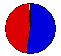
 | Thomas Dewey | John Bricker | Republican |
875,891 |
52.38% | 13 |
 | Franklin Roosevelt | Harry Truman | Democrat |
781,403 |
46.73% | 0 |
 | Claude Watson | Andrew Johnson | Prohibition |
12,574 |
0.75% | 0 |
| Norman Thomas | Darlington Hoopes | Socialist |
2,223 |
0.13% | 0 |
 |
Map Key
| Turnout
 |  |  |
|
| Maps | County Map (m) |  | | Rep. (m) | | Dem. (m) | | Swg (m) | | Tnd (m) |
| |
| Demographic Data
| 1950 Population: | 3,934,224 | Enum. | 1950 Population Density: | 42.4 | persons/km2 | | 1940 Population: | 3,427,796 | Enum. | 1940 Population Density: | 36.9 | persons/km2 | | Total Electoral Vote: | 13 | | | Land Area (2000): | 92,895 | km2 | Annual Pop Growth Rate: | 1.4 | % |
| Election Data and Statistics:
- County Data (Table) (m)
- County Data (Graphs) (m)
|
| | Election Tools
- Atlas Forum Image Code for Maps: County, Tnd, Swg
Data Sources:
- Source for Popular Vote data: Indiana Division of Accounting and Statistics, "General Election Returns, November 7, 1944 Presidential Electors at Large," Year Book of the State of Indiana for the Year 1944 (Indianapolis, 1945)
- Source for Population data: U.S. Census Bureau.
| Results for and Individual County:
|
|
| |


