| |
Presidential
Candidate | Vice Presidential
Candidate | Political
Party | Popular Vote | Electoral Vote |
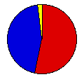
 | Franklin Roosevelt | John Garner | Democratic |
424,204 |
53.56% | 9 |
 | Herbert Hoover | Charles Curtis | Republican |
349,498 |
44.13% | 0 |
 | Norman Thomas | James Maurer | Socialist |
18,276 |
2.31% | 0 |
 |
Map Key
| Turnout
 |  |  |
|
| Maps | County Map (m) |  | | Dem. (m) | | Rep. (m) | | Swg (m) | | Tnd (m) |
| |
| Demographic Data
| 1940 Population: | 1,801,028 | Enum. | 1940 Population Density: | 8.5 | persons/km2 | | 1930 Population: | 1,880,999 | Enum. | 1930 Population Density: | 8.9 | persons/km2 | | Total Electoral Vote: | 9 | | | Land Area (2000): | 211,900 | km2 | Annual Pop Growth Rate: | -0.4 | % |
| Election Data and Statistics:
- County Data (Table) (m)
- County Data (Graphs) (m)
|
| | Election Tools
- Atlas Forum Image Code for Maps: County, Tnd, Swg
Data Sources:
- Source for Popular Vote data: Kansas Secretary of State, "General Election, November 8, 1932 For President and Vice President," Twenty-eighth Biennial Report of the Secretary of State 1931-1932 (Topeka: Kansas State Printing Plant, 1932)
- Source for Population data: U.S. Census Bureau.
| Results for and Individual County:
|
|
| |


