| |
Presidential
Candidate | Vice Presidential
Candidate | Political
Party | Popular Vote | Electoral Vote |
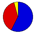
 | William McKinley | Theodore Roosevelt | Republican |
238,866 |
57.59% | 15 |
 | William Bryan | Adlai Stevenson | Democrat |
156,997 |
37.85% | 0 |
 | Eugene Debs | Job Harriman | Democratic Social |
9,607 |
2.32% | 0 |
| John Woolley | Henry Metcalf | Prohibition |
6,202 |
1.50% | 0 |
| Joseph Maloney | Valentine Remmel | Socialist Labor |
2,599 |
0.63% | 0 |
| Write-ins | - | X |
533 |
0.13% | 0 |
 |
Map Key
| Turnout
 |  |  |
|
| Maps | County Map (m) |  |
| |
| Demographic Data
| 1900 Population: | 2,805,346 | Enum. | 1900 Population Density: | 138.2 | persons/km2 | | 1890 Population: | 0 | Enum. | 1890 Population Density: | 0.0 | persons/km2 | | Total Electoral Vote: | 15 | | Electoral Vote Density: | 187,023 | persons/EV | | Land Area (2000): | 20,306 | km2 | Annual Pop Growth Rate: | 0 | % |
| Election Data and Statistics:
- County Data (Table) (m)
- County Data (Graphs) (m)
|
| | Election Tools
- Atlas Forum Image Code for Maps: County
Data Sources:
- Source for Popular Vote data: Massachusetts Secretary of State, "Number of Votes Received by Each Candidate for a State Office at the Annual State Election, Nov. 6, 1900," Public Document #43 1900 (Boston, 1901)
- Source for Population data: U.S. Census Bureau.
| Results for and Individual County:
|
|
| |


