| |
Presidential
Candidate | Vice Presidential
Candidate | Political
Party | Popular Vote | Electoral Vote |
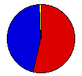
 | William Bryan | Arthur Sewall | Democrat |
363,667 |
53.96% | 17 |
 | William McKinley | Garret Hobart | Republican |
304,940 |
45.25% | 0 |
 | John Palmer | Simon Buckner | Nat'l Democrat |
2,365 |
0.35% | 0 |
| Joshua Levering | Hale Johnson | Prohibition |
2,043 |
0.30% | 0 |
| Other (+) | - | - |
891 |
0.13% | 0 |
 |
Map Key
| > 40% |
 |
 |
| > 50% |
 |
 |
| > 60% |
 |
 |
| > 70% |
 |
 |
| > 80% |
 |
 |
| Turnout
 |  |  |
|
| Maps | County Map (m) |  |
| |
| Election Notes:
- Data for Bryan is the fusion of Democratic and People's Parties
- Four Presidential Electors cast their Vice Presidential ballots for Thomas Watson.
| Demographic Data
| 1900 Population: | 3,106,665 | Enum. | 1900 Population Density: | 17.4 | persons/km2 | | 1890 Population: | 0 | Enum. | 1890 Population Density: | 0.0 | persons/km2 | | Total Electoral Vote: | 17 | | | Land Area (2000): | 178,414 | km2 | Annual Pop Growth Rate: | 0 | % |
| Election Data and Statistics:
- County Data (Table) (m)
- County Data (Graphs) (m)
|
| | Election Tools
- Atlas Forum Image Code for Maps: County
Data Sources:
- Source for Popular Vote data: Missouri Secretary of State, comp., "Vote for President and Governor, 1896," Official Manual of the State of Missouri for the Years 1897-98 (Jefferson City: Tribune Printing Company, 1897)
- Source for Population data: U.S. Census Bureau.
| Results for and Individual County:
|
|
| |


