| |
Presidential
Candidate | Vice Presidential
Candidate | Political
Party | Popular Vote | Electoral Vote |
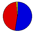
 | Gerald Ford | Robert Dole | Republican |
173,703 |
52.84% | 4 |
 | James Carter | Walter Mondale | Democrat |
149,259 |
45.40% | 0 |
 | Thomas Anderson | Rufus Shackelford | Americanist |
5,772 |
1.76% | 0 |
 |
Map Key
| Turnout
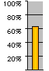 |  |  |
|
| Maps | 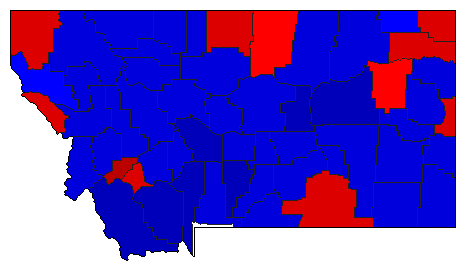 |  | | Pop. (m) | | C.D. (m) | | Rep. (m) | | Dem. (m) | | Swg (m) | | Tnd (m) |
| |
| Demographic Data
| 1980 Population: | 786,690 | Enum. | 1980 Population Density: | 2.1 | persons/km2 | | 1976 Population: | 758,521 | Est. | 1976 Population Density: | 2.0 | persons/km2 | | 1970 Population: | 694,409 | Enum. | 1970 Population Density: | 1.8 | persons/km2 | | Total Electoral Vote: | 4 | | Electoral Vote Density: | 189,630 | persons/EV | | Land Area (2000): | 376,979 | km2 | Annual Pop Growth Rate: | 1.3 | % |
| Election Data and Statistics:
- County Data (Table) (m)
- County Data (Graphs)
- Congressional District Data (m)
- Voter Registration & Turnout Data (m)
|
| | Election Tools
- Atlas Forum Image Code for Maps: County, CD, Pop, Tnd, Swg
Data Sources:
- Source for Popular Vote data: Montana Secretary of State, Report of the Official Canvass of the Vote Cast at the General Election Held in the State of Montana, November 2, 1976 (Helena, 0)
- Source for Population data: U.S. Census Bureau.
| Results for and Individual County:
|
|
| |


