| |
Presidential
Candidate | Vice Presidential
Candidate | Political
Party | Popular Vote | Electoral Vote |
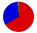
 | Franklin Roosevelt | John Garner | Democratic |
259,473 |
66.49% | 11 |
 | Herbert Hoover | Charles Curtis | Republican |
126,752 |
32.48% | 0 |
 | William Upshaw | Frank Regan | Prohibition |
1,998 |
0.51% | 0 |
| Norman Thomas | James Maurer | Socialist |
1,796 |
0.46% | 0 |
| William Foster | James Ford | Communist |
237 |
0.06% | 0 |
 |
Map Key
| > 50% |
 |
 |
| > 60% |
 |
 |
| > 70% |
 |
 |
| > 80% |
 |
 |
| > 90% |
 |
 |
| Turnout
 |  |  |
|
| Maps | County Map (m) |  | | Dem. (m) | | Rep. (m) | | Swg (m) | | Tnd (m) |
| |
| Demographic Data
| 1940 Population: | 2,915,841 | Enum. | 1940 Population Density: | 27.3 | persons/km2 | | 1930 Population: | 2,616,556 | Enum. | 1930 Population Density: | 24.5 | persons/km2 | | Total Electoral Vote: | 11 | | | Land Area (2000): | 106,752 | km2 | Annual Pop Growth Rate: | 1.1 | % |
| Election Data and Statistics:
- County Data (Table) (m)
- County Data (Graphs) (m)
|
| | Election Tools
- Atlas Forum Image Code for Maps: County, Tnd, Swg
Data Sources:
- Source for Popular Vote data: Tennessee Secretary of State, "General Election Returns - November 8, 1932 for President," Tennessee Blue Book and Official Directory Official Vote, 1932 (Nashville, 1934)
- Source for Population data: U.S. Census Bureau.
| Results for and Individual County:
|
|
| |


