| |
Presidential
Candidate | Vice Presidential
Candidate | Political
Party | Popular Vote | Electoral Vote |
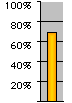
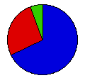
 | Richard Nixon | Spiro Agnew | Republican |
323,643 |
67.64% | 4 |
 | George McGovern | R. Sargent Shriver | Democrat |
126,284 |
26.39% | 0 |
 | John Schmitz | Thomas Anderson | American Ind. |
28,549 |
5.97% | 0 |
 |
Map Key
| Turnout
 |  |  |
|
| Maps |  |  | | Pop. (m) | | Rep. (m) | | Dem. (m) | | Ame. (m) | | Swg (m) | | Tnd (m) |
| |
| Demographic Data
| 1980 Population: | 1,461,037 | Enum. | 1980 Population Density: | 6.9 | persons/km2 | | 1972 Population: | 1,134,601 | Est. | 1972 Population Density: | 5.3 | persons/km2 | | 1970 Population: | 1,059,273 | Enum. | 1970 Population Density: | 5.0 | persons/km2 | | Total Electoral Vote: | 4 | | Electoral Vote Density: | 283,650 | persons/EV | | Land Area (2000): | 212,751 | km2 | Annual Pop Growth Rate: | 3.3 | % |
| Election Data and Statistics:
| Election Tools
- Atlas Forum Image Code for Maps: County, Pop, Tnd, Swg
Data Sources:
- Source for Popular Vote data: Utah, Abstract of the Returns of the General Election Held in the State of Utah (Salt Lake City, 1972)
- Source for Population data: U.S. Census Bureau.
| Results for and Individual County:
|
|
| |


