| |
Presidential
Candidate | Vice Presidential
Candidate | Political
Party | Popular Vote | Electoral Vote |
 | Gerald Ford | Robert Dole | Republican |
337,908 |
62.44% | 4 |
 | James Carter | Walter Mondale | Democrat |
182,110 |
33.65% | 0 |
 | Thomas Anderson | Rufus Shackelford | American |
13,284 |
2.45% | 0 |
| Eugene McCarthy | John Stauffer | Court Order |
3,907 |
0.72% | 0 |
| Roger MacBride | David Bergland | Libertarian |
2,438 |
0.45% | 0 |
| Other (+) | - | - |
1,551 |
0.29% | 0 |
 |
Map Key
| Turnout
 |  |  |
|
| Maps | 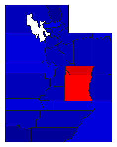 |  | | Pop. (m) | | C.D. (m) | | Rep. (m) | | Dem. (m) | | Swg (m) | | Tnd (m) |
| |
| Demographic Data
| 1980 Population: | 1,461,037 | Enum. | 1980 Population Density: | 6.9 | persons/km2 | | 1976 Population: | 1,272,365 | Est. | 1976 Population Density: | 6.0 | persons/km2 | | 1970 Population: | 1,059,273 | Enum. | 1970 Population Density: | 5.0 | persons/km2 | | Total Electoral Vote: | 4 | | Electoral Vote Density: | 318,091 | persons/EV | | Land Area (2000): | 212,751 | km2 | Annual Pop Growth Rate: | 3.3 | % |
| Election Data and Statistics:
- County Data (Table) (m)
- County Data (Graphs)
- Congressional District Data (m)
- Voter Registration & Turnout Data (m)
|
| | Election Tools
- Atlas Forum Image Code for Maps: County, CD, Pop, Tnd, Swg
Data Sources:
- Source for Popular Vote data: Utah, Abstract of the returns of the general election held in the State of Utah November 2, 1976 (Salt Lake City, 1976)
- Source for Population data: U.S. Census Bureau.
| Results for and Individual County:
|
|
| |


