| |
Presidential
Candidate | Vice Presidential
Candidate | Political
Party | Popular Vote | Electoral Vote |
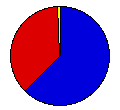
 | Richard Nixon | Spiro Agnew | Republican |
117,149 |
62.66% | 3 |
 | George McGovern | R. Sargent Shriver | Democrat |
68,174 |
36.47% | 0 |
 | Benjamin Spock | Julius Hobson | Liberty Union |
1,010 |
0.54% | 0 |
| Other (+) | - | - |
613 |
0.33% | 0 |
 |
Map Key
| Turnout
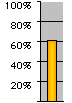 |  |  |
|
| Maps | 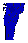 |  | | Pop. (m) | | C.D. (m) | | Rep. (m) | | Dem. (m) | | Swg (m) | | Tnd (m) |
| |
| Demographic Data
| 1980 Population: | 511,456 | Enum. | 1980 Population Density: | 21.3 | persons/km2 | | 1972 Population: | 463,214 | Est. | 1972 Population Density: | 19.3 | persons/km2 | | 1970 Population: | 444,732 | Enum. | 1970 Population Density: | 18.6 | persons/km2 | | Total Electoral Vote: | 3 | | Electoral Vote Density: | 154,405 | persons/EV | | Land Area (2000): | 23,956 | km2 | Annual Pop Growth Rate: | 1.4 | % |
| Election Data and Statistics:
| Election Tools
- Atlas Forum Image Code for Maps: County, CD, Pop, Tnd, Swg
Data Sources:
- Source for Popular Vote data: Vermont Secretary of State, Canvass of Votes for Presidential Electors General Election - November 7, 1972 (Rutland, 0)
- Source for Population data: U.S. Census Bureau.
| Results for and Individual County:
|
|
| |


