| |
Presidential
Candidate | Vice Presidential
Candidate | Political
Party | Popular Vote | Electoral Vote |
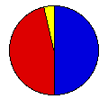
 | Gerald Ford | Robert Dole | Republican |
777,732 |
50.00% | 8 |
 | James Carter | Walter Mondale | Democrat |
717,323 |
46.11% | 0 |
 | Eugene McCarthy | Maxey | Independent |
36,986 |
2.38% | 0 |
| Lester Maddox | William Dyke | Right. Gov't |
8,585 |
0.55% | 0 |
| Thomas Anderson | Rufus Shackelford | Am. Const. |
5,046 |
0.32% | 0 |
| Roger MacBride | David Bergland | Libertarian |
5,042 |
0.32% | 0 |
| Other (+) | - | - |
4,820 |
0.31% | 1 |
 |
Map Key
| Turnout
 |  |  |
|
| Maps | 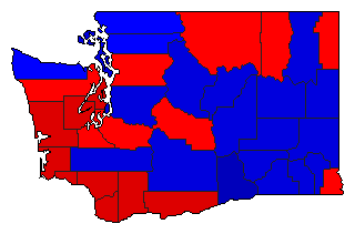 |  | | Pop. (m) | | Rep. (m) | | Dem. (m) | | Swg (m) | | Tnd (m) |
| |
| Election Notes:
- One Ford Elector cast his ballot for Ronald Reagan (President) and Bob Dole (Vice President).
| Demographic Data
| 1980 Population: | 4,132,353 | Enum. | 1980 Population Density: | 24.0 | persons/km2 | | 1976 Population: | 3,690,561 | Est. | 1976 Population Density: | 21.4 | persons/km2 | | 1970 Population: | 3,413,244 | Enum. | 1970 Population Density: | 19.8 | persons/km2 | | Total Electoral Vote: | 9 | | Electoral Vote Density: | 410,062 | persons/EV | | Land Area (2000): | 172,348 | km2 | Annual Pop Growth Rate: | 1.9 | % |
| Election Data and Statistics:
| Election Tools
- Atlas Forum Image Code for Maps: County, Pop, Tnd, Swg
Data Sources:
- Source for Popular Vote data: Washington Secretary of State, "President & Vice President," Abstract of Votes Primary and General Elections Held on September 21, 1976 and November 2, 1976 (Olympia, 1976)
- Source for Population data: U.S. Census Bureau.
| Results for and Individual County:
|
|
| |


