| |
Presidential
Candidate | Vice Presidential
Candidate | Political
Party | Popular Vote | Electoral Vote |
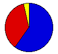
 | William McKinley | Theodore Roosevelt | Republican |
265,760 |
60.06% | 12 |
 | William Bryan | Adlai Stevenson | Democrat |
159,163 |
35.97% | 0 |
 | John Woolley | Henry Metcalf | Prohibition |
10,027 |
2.27% | 0 |
| Eugene Debs | Job Harriman | Social Democrat |
7,048 |
1.59% | 0 |
| Joseph Maloney | Valentine Remmel | Socialist Labor |
503 |
0.11% | 0 |
 |
Map Key
| > 40% |
 |
 |
| > 50% |
 |
 |
| > 60% |
|
 |
| > 70% |
|
 |
| > 80% |
|
 |
| Turnout
 |  |  |
|
| Maps | County Map (m) |  |
| |
| Demographic Data
| 1900 Population: | 2,069,042 | Enum. | 1900 Population Density: | 14.7 | persons/km2 | | 1890 Population: | 0 | Enum. | 1890 Population Density: | 0.0 | persons/km2 | | Total Electoral Vote: | 12 | | Electoral Vote Density: | 172,420 | persons/EV | | Land Area (2000): | 140,663 | km2 | Annual Pop Growth Rate: | 0 | % |
| Election Data and Statistics:
- County Data (Table) (m)
- County Data (Graphs) (m)
|
| | Election Tools
- Atlas Forum Image Code for Maps: County
Data Sources:
- Source for Popular Vote data: Wisconsin, comp., "Comparative Vote for President, 1900 and 1896," The Blue Book for the State of Wisconsin, for 1901 (Madison, 1901)
- Source for Population data: U.S. Census Bureau.
| Results for and Individual County:
|
|
| |


