| |
Presidential
Candidate | Vice Presidential
Candidate | Political
Party | Popular Vote | Electoral Vote |
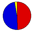
 | James Carter | Walter Mondale | Democrat |
1,040,232 |
49.50% | 11 |
 | Gerald Ford | Robert Dole | Republican |
1,004,987 |
47.83% | 0 |
 | Eugene McCarthy | Magdalene Downey | Independent |
34,943 |
1.66% | 0 |
| Lester Maddox | William Dyke | American |
8,552 |
0.41% | 0 |
| Other (+) | - | - |
12,622 |
0.60% | 0 |
 |
Map Key
| Turnout
 |  |  |
|
| Maps | 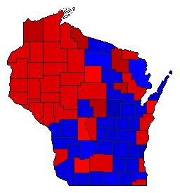 |  | | Pop. (m) | | Dem. (m) | | Rep. (m) | | Swg (m) | | Tnd (m) |
| |
| Demographic Data
| 1980 Population: | 4,705,642 | Enum. | 1980 Population Density: | 33.5 | persons/km2 | | 1976 Population: | 4,584,688 | Est. | 1976 Population Density: | 32.6 | persons/km2 | | 1970 Population: | 4,417,821 | Enum. | 1970 Population Density: | 31.4 | persons/km2 | | Total Electoral Vote: | 11 | | Electoral Vote Density: | 416,790 | persons/EV | | Land Area (2000): | 140,663 | km2 | Annual Pop Growth Rate: | 0.6 | % |
| Election Data and Statistics:
| Election Tools
- Atlas Forum Image Code for Maps: County, Pop, Tnd, Swg
Data Sources:
- Source for Popular Vote data: Wisconsin Legislative Reference Bureau, comp., "General Election, November 2, 1976 Vote for President and Vice President By County," State of Wisconsin 1977 Blue Book (Madison, 1977)
- Source for Population data: U.S. Census Bureau.
| Results for and Individual County:
|
|
| |


