| |
Presidential
Candidate | Vice Presidential
Candidate | Political
Party | Popular Vote | Electoral Vote |
 | Gerald Ford | Robert Dole | Republican |
584,367 |
54.05% | 7 |
 | James Carter | Walter Mondale | Democrat |
460,353 |
42.58% | 0 |
 | Eugene McCarthy | Surges | Independent |
26,107 |
2.41% | 0 |
| Roger MacBride | David Bergland | Libertarian |
5,330 |
0.49% | 0 |
| Benjamin Bubar | Earl Dodge | CO Prohibition |
2,882 |
0.27% | 0 |
| Other (+) | - | - |
2,096 |
0.19% | 0 |
 |
Map Key
| Turnout
 |  |  |
|
| Maps | 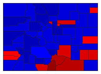 |  | | Pop. (m) | | Rep. (m) | | Dem. (m) | | Swg (m) | | Tnd (m) |
| |
| Demographic Data
| 1980 Population: | 2,889,735 | Enum. | 1980 Population Density: | 10.8 | persons/km2 | | 1976 Population: | 2,632,244 | Est. | 1976 Population Density: | 9.8 | persons/km2 | | 1970 Population: | 2,209,596 | Enum. | 1970 Population Density: | 8.2 | persons/km2 | | Total Electoral Vote: | 7 | | Electoral Vote Density: | 376,035 | persons/EV | | Land Area (2000): | 268,627 | km2 | Annual Pop Growth Rate: | 2.7 | % |
| Election Data and Statistics:
| Election Tools
- Atlas Forum Image Code for Maps: County, Pop, Tnd, Swg
Data Sources:
- Source for Popular Vote data: Colorado Secretary of State, Abstract of Votes Cast at the General Election Held on Tuesday, November 2, 1976 (Denver, 1976)
- Source for Population data: U.S. Census Bureau.
| Results for and Individual County:
|
|
| |


