| |
Presidential
Candidate | Vice Presidential
Candidate | Political
Party | Popular Vote | Electoral Vote |
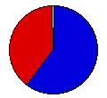
 | Thomas Dewey | John Bricker | Republican |
442,096 |
60.25% | 8 |
 | Franklin Roosevelt | Harry Truman | Democrat |
287,458 |
39.18% | 0 |
 | Claude Watson | Andrew Johnson | Prohibition |
2,609 |
0.36% | 0 |
| Norman Thomas | Darlington Hoopes | Socialist |
1,613 |
0.22% | 0 |
 |
Map Key
| Turnout
 |  |  |
|
| Maps | County Map (m) |  | | Rep. (m) | | Dem. (m) | | Swg (m) | | Tnd (m) |
| |
| Demographic Data
| 1950 Population: | 1,905,299 | Enum. | 1950 Population Density: | 9.0 | persons/km2 | | 1940 Population: | 1,801,028 | Enum. | 1940 Population Density: | 8.5 | persons/km2 | | Total Electoral Vote: | 8 | | | Land Area (2000): | 211,900 | km2 | Annual Pop Growth Rate: | 0.6 | % |
| Election Data and Statistics:
- County Data (Table) (m)
- County Data (Graphs) (m)
|
| | Election Tools
- Atlas Forum Image Code for Maps: County, Tnd, Swg
Data Sources:
- Source for Popular Vote data: Kansas Secretary of State, "General Election, November 7, 1944 For Electors of President and Vice President," Thirty-fourth Biennial Report of the Secretary of State 1943-1944 (Topeka: Kansas State Printing Plant, 1944)
- Source for Population data: U.S. Census Bureau.
| Results for and Individual County:
|
|
| |


