-
** ** 1974 Gubernatorial General Election Results - Maine ** **
-
Data for this Contest was Contributed by on 2019-07-08

  Gubernatorial
Candidate
Political
Party
Popular Vote
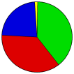
James LongleyIndependent 142,464 39.14%
George J. MitchellDemocratic 132,219 36.33%
James ErwinRepublican 84,176 23.13%
Stanley Leen JrIndependent 2,883 0.79%
William Brown HughesIndependent 1,314 0.36%
Leith HartmanIndependent (W/I) 889 0.24%
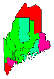
State Seal Map Key
 > 30%
 > 40%
 > 50%
 > 60%
Turnout
Voter Turnout Graph
Vote Pie Chart
Maps
  1974 Maine County Map of General Election Results for Governor  
County Button
Pop. (m)
Per Vote Independent Button
Per Vote Democratic Button
Per Vote Republican Button
 
Demographic Data

1980 Population:1,125,043Enum.1980 Population Density:14.1persons/km2
1974 Population:0Est.1974 Population Density:0.0persons/km2
1970 Population:993,722Enum.1970 Population Density:12.4persons/km2
Land Area (2000):79,931km2Annual Pop Growth Rate:1.2%

Election Data and Statistics:
Election Tools
Data Sources:
  • Source for Popular Vote data: Maine Bureau of Corporations, Elections and Commissions. 1974 General Election: Governor, Maine Bureau of Corporations, Elections and Commissions (https://digitalmaine.com/cgi/viewcontent.cgi?article=1034&context=tabulations_for_elections_1970s) (accessed 29 June 2019)
  • Source for Population data: U.S. Census Bureau.
Results for and Individual County:
  • (m)
  • County Menu (m)

National Results for 1974 - View No-Frames Version of this Page

Login

Terms of Use - DCMA Policy - Privacy Policy and Cookies


© Dave Leip's Atlas of U.S. Elections, LLC 2019 All Rights Reserved

Note: The advertisement links below may advocate political positions that this site does not endorse.
Androscoggin County Aroostook County Cumberland County Franklin County Hancock County Kennebec County Knox County Lincoln County Oxford County Penobscot County Piscataquis County Sagadahoc County Somerset County Waldo County Washington County York County