1964 Initiative General Election Results - Massachusetts
Note: The Google advertisement links below may advocate political positions that this site does not endorse.
Data for this Contest was Contributed by on 2015-07-27

  Initiative: Question 5: Limiting Authority of the Executive CouncilPopular Vote
Yes 1,133,624 65.80%
No 589,219 34.20%
State Seal Map Key
 > 40%
 > 50%
 > 60%
 > 70%
Turnout
Voter Turnout Graph
Vote Pie Chart
Maps
  1964 Massachusetts County Map of General Election Results for Initiative  
County Button
Per Vote  Button
Per Vote  Button
 
Election Notes:
  • The proposed statute would eliminate the statutory authority of the Governor's Council.
Demographic Data

1970 Population:5,689,170Enum.1970 Population Density:280.2persons/km2
1960 Population:5,148,578Enum.1960 Population Density:253.5persons/km2
Land Area (2000):20,306km2Annual Pop Growth Rate:1.0%

Election Data and Statistics:
Election Tools
Data Sources:
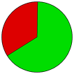
  • Source for Popular Vote data: Massachusetts Secretary of the Commonwealth. Election Statistics The Commonwealth of Massachusetts 1964, Massachusetts Secretary of the Commonwealth (https://archive.org/stream/electionstatisti1964mass#page/564/mode/2up) (accessed 27 Jul 2015)
  • Source for Population data: U.S. Census Bureau.
Results for and Individual County:
  • (m)


Barnstable County Berkshire County Bristol County Dukes County Essex County Franklin County Hampden County Hampshire County Middlesex County Nantucket County Norfolk County Plymouth County Suffolk County Worcester County