| |
Gubernatorial
Candidate | Lt. Gubernatorial
Candidate | Political
Party | Popular Vote |
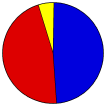
 | Charlie Baker | Karyn Polito | Republican |
1,044,573 |
48.40% |
 | Martha Coakley | Steve Kerrigan | Democratic |
1,004,408 |
46.54% |
 | Evan Falchuk | Angus Jennings | United Independent |
71,814 |
3.33% |
| Scott Lively | Shelly Saunders | Independent |
19,378 |
0.90% |
| Jeff McCormick | Tracy Post | Independent |
16,295 |
0.75% |
| Write-ins | - | - |
1,858 |
0.09% |
 |
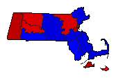
Map Key
| Turnout
 |  |
|
|
| Demographic Data
| 2014 Population: | 6,764,864 | Est. | 2014 Population Density: | 333.1 | persons/km2 | | 2010 Population: | 6,547,629 | Enum. | 2010 Population Density: | 322.4 | persons/km2 | | Land Area (2000): | 20,306 | km2 | Annual Pop Growth Rate: | 0.8 | % |
| Election Data and Statistics:
| Election Tools
- Atlas Forum Image Code for Maps: County, Town, Pop, Tnd, Swg
Data Sources:
- Source for Popular Vote data: Massachusetts Secretary of the Commonwealth. Elections Division. PD43+ Massachusetts Election Statistics, Massachusetts Secretary of the Commonwealth. Elections Division (http://electionstats.state.ma.us/elections/view/35901/
) (accessed 04 Dec 2014)
- Source for Population data: U.S. Census Bureau.
| Results for and Individual County:
|
| The 2014 Campaign:
|
|
| |


