| |
Presidential
Candidate | Vice Presidential
Candidate | Political
Party | Popular Vote | Electoral Vote |
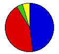
 | Benjamin Harrison | Whitelaw Reid | Republican |
222,708 |
47.79% | 9 |
 | Grover Cleveland | Adlai Stevenson | Democrat |
201,624 |
43.26% | 5 |
 | John Bidwell | James Cranfill | Prohibition |
20,857 |
4.48% | 0 |
 | James Weaver | James Field | People |
19,931 |
4.28% | 0 |
| Write-ins | - | - |
925 |
0.20% | 0 |
 |
Map Key
| > 30% |
 |
|  |
| > 40% |
 |
 | |
| > 50% |
 |
 | |
| > 60% |
 |
 | |
| > 90% |
 |
| |
| Turnout
 |  |  |
|
| Maps | County Map (m) |  |
| |
| Election Notes:
- Figures include county returns absent from Official Canvass.
- Includes corrected figures for Cleveland in Tuscola and Wayne Counties.
- Electors were selected using the congressional district method (the winner in each congressional district wins one electoral vote, the winner of the state wins two electoral votes). This resulted in a split between the Republican and Democratic electors: nine for Harrison and five for Cleveland.
| Demographic Data
| 1900 Population: | 2,420,982 | Enum. | 1900 Population Density: | 16.5 | persons/km2 | | 1890 Population: | 0 | Enum. | 1890 Population Density: | 0.0 | persons/km2 | | Total Electoral Vote: | 14 | | | Land Area (2000): | 147,121 | km2 | Annual Pop Growth Rate: | 0 | % |
| Election Data and Statistics:
- County Data (Table) (m)
- County Data (Graphs) (m)
|
| | Election Tools
- Atlas Forum Image Code for Maps: County
Data Sources:
- Source for Popular Vote data: Michigan Department of State, comp., "Presidential Vote in Michigan from 1836 to 1916," Michigan Official Directory and Legislative Manual 1917-1918 (Lansing, 1917)
- Source for Population data: U.S. Census Bureau.
| Results for and Individual County:
|
|
| |


