| |
Presidential
Candidate | Vice Presidential
Candidate | Political
Party | Popular Vote | Electoral Vote |
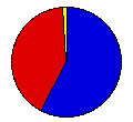
 | Herbert Hoover | Charles Curtis | Republican |
560,977 |
57.77% | 12 |
 | Alfred Smith | Joseph Robinson | Democrat |
396,451 |
40.83% | 0 |
 | Norman Thomas | James Maurer | Socialist |
6,774 |
0.70% | 0 |
| William Foster | Benjamin Gitlow | Wrks Comm. |
4,853 |
0.50% | 0 |
| Verne Reynolds | Jeremiah Crowley | Industrial |
1,921 |
0.20% | 0 |
 |
Map Key
| Turnout
 |  |  |
|
| Maps | County Map (m) |  | | Rep. (m) | | Dem. (m) | | Swg (m) | | Tnd (m) |
| |
| Demographic Data
| 1930 Population: | 2,563,953 | Enum. | 1930 Population Density: | 12.4 | persons/km2 | | 1920 Population: | 2,387,125 | Enum. | 1920 Population Density: | 11.6 | persons/km2 | | Total Electoral Vote: | 12 | | | Land Area (2000): | 206,189 | km2 | Annual Pop Growth Rate: | 0.7 | % |
| Election Data and Statistics:
- County Data (Table) (m)
- County Data (Graphs) (m)
|
| | Election Tools
- Atlas Forum Image Code for Maps: County, Tnd, Swg
Data Sources:
- Source for Popular Vote data: Minnesota Secretary of State, "Vote by Counties of Presidential Electors," The Legislative Manual of the State of Minnesota 1929 (St. Paul, 1929)
- Source for Population data: U.S. Census Bureau.
| Results for and Individual County:
|
|
| |


