| |
Presidential
Candidate | Vice Presidential
Candidate | Political
Party | Popular Vote | Electoral Vote |
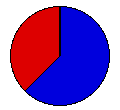
 | Richard Nixon | Spiro Agnew | Republican |
1,154,058 |
62.29% | 12 |
 | George McGovern | R. Sargent Shriver | Democrat |
698,531 |
37.71% | 0 |
 |
Map Key
| Turnout
 |  |  |
|
| Maps | 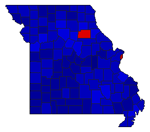 |  | | Pop. (m) | | Rep. (m) | | Dem. (m) | | Swg (m) | | Tnd (m) |
| |
| Demographic Data
| 1980 Population: | 4,916,766 | Enum. | 1980 Population Density: | 27.6 | persons/km2 | | 1972 Population: | 4,753,234 | Est. | 1972 Population Density: | 26.6 | persons/km2 | | 1970 Population: | 4,677,623 | Enum. | 1970 Population Density: | 26.2 | persons/km2 | | Total Electoral Vote: | 12 | | Electoral Vote Density: | 396,103 | persons/EV | | Land Area (2000): | 178,414 | km2 | Annual Pop Growth Rate: | 0.5 | % |
| Election Data and Statistics:
| Election Tools
- Atlas Forum Image Code for Maps: County, Pop, Tnd, Swg
Data Sources:
- Source for Popular Vote data: Missouri Secretary of State, "General Election Returns Vote for President, By Counties, at General Election November 7, 1972," Official Manual State of Missouri 1973-1974 (Jefferson City, 1973)
- Source for Population data: U.S. Census Bureau.
| Results for and Individual County:
|
|
| |


