Note: The Google advertisement links below may advocate political positions that this site does not endorse.
  Gubernatorial
Candidate
Lt. Gubernatorial
Candidate
Political
Party
Popular Vote
Greg GianforteKristen JurasRepublican 328,548 54.43%
Mike CooneyCasey SchreinerDemocratic 250,860 41.56%
Lyman BishopJohn NesperLibertarian 24,179 4.01%
Chris HallDarren E. HallWrite-in 21 0.00%
State Seal Map Key
 > 40%
 > 50%
 > 60%
 > 70%
 > 80%
 > 90%
Turnout
Voter Turnout Graph
Vote Pie Chart
Maps
  2020 Montana County Map of General Election Results for Governor  
County Button
2000 Button
Pop Button
Cong Dist Button
Per Vote Republican Button
Per Vote Democratic Button
Swing Map Button
Trend Map Button
 
Election Data and Statistics:
Election Tools
Data Sources:
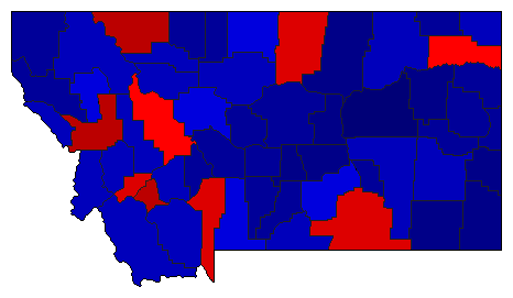
  • Source for Popular Vote data: Montana Secretary of State Elections. 2020 Statewide General Election Canvass Governor & Lt. Governor, Montana Secretary of State Elections (https://sosmt.gov/wp-content/uploads/State_Canvass_Report.pdf) (accessed 2020-11-30)
  • Source for Population data: U.S. Census Bureau.
Results for and Individual County:
The 2020 Campaign:


Beaverhead County Big Horn County Blaine County Broadwater County Carbon County Carter County Cascade County Chouteau County Custer County Daniels County Dawson County Deer Lodge County Fallon County Fergus County Flathead County Gallatin County Garfield County Glacier County Golden Valley County Granite County Hill County Jefferson County Judith Basin County Lake County Lewis and Clark County Liberty County Lincoln County McCone County Madison County Meagher County Mineral County Missoula County Musselshell County Park County Petroleum County Phillips County Pondera County Powder River County Powell County Prairie County Ravalli County Richland County Roosevelt County Rosebud County Sanders County Sheridan County Silver Bow County Stillwater County Sweet Grass County Teton County Toole County Treasure County Valley County Wheatland County Wibaux County Yellowstone County