| |
Presidential
Candidate | Vice Presidential
Candidate | Political
Party | Popular Vote | Electoral Vote |
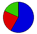
 | Calvin Coolidge | Charles Dawes | Republican |
1,176,130 |
58.33% | 24 |
 | John Davis | Charles Bryan | Democrat |
477,888 |
23.70% | 0 |
 | Robert LaFollette | Burton Wheeler | Ind. Prog. |
357,948 |
17.75% | 0 |
 | Other (+) | - | - |
4,271 |
0.21% | 0 |
 |
Map Key
| Turnout
 |  |  |
|
| Maps | County Map (m) |  | | Rep. (m) | | Dem. (m) | | Ind. (m) | | Swg (m) | | Tnd (m) |
| |
| Demographic Data
| 1930 Population: | 6,646,697 | Enum. | 1930 Population Density: | 62.7 | persons/km2 | | 1920 Population: | 5,759,394 | Enum. | 1920 Population Density: | 54.3 | persons/km2 | | Total Electoral Vote: | 24 | | | Land Area (2000): | 106,056 | km2 | Annual Pop Growth Rate: | 1.4 | % |
| Election Data and Statistics:
- County Data (Table) (m)
- County Data (Graphs) (m)
|
| | Election Tools
- Atlas Forum Image Code for Maps: County, Tnd, Swg
Data Sources:
- Source for Popular Vote data: Ohio Secretary of State, comp., Vote for President, ... Polled in the Several Counties of the State of Ohio at the Election Held ... Fourth day of November, 1924 (Springfield, 1924)
- Source for Population data: U.S. Census Bureau.
| Results for and Individual County:
|
|
| |


